Somi Sareen*![]() | Mazharul Haque
| Mazharul Haque![]()
© 2023 IIETA. This article is published by IIETA and is licensed under the CC BY 4.0 license (http://creativecommons.org/licenses/by/4.0/).
OPEN ACCESS
Peri-urban regions have evolved from a conceptual place and process to a heterogeneous location competing for spatial equity. Despite numerous studies on peri-urban planning, the non-judicious planning process and the lack of evidence-based decision-making remain pertinent issues in peri-urban areas. Although research on peri-urban planning is increasing, establishing standardized frameworks and facilitating cross-regional comparisons still require a widely adopted and unambiguous approach. Furthermore, there is a lack of understanding of how peri-urban areas function and the intrinsic variability within this vast domain. The paper seeks to comprehend the evolution of peri-urban areas and to suggest critical areas for sustainable peri-urban planning by employing science mapping tools to assess 622 articles from the Web of Science, which were selected from a total of 1,102 articles. According to the findings, peri-urban planning extends beyond the fundamentals of planning and now encompasses a wide range of subjects. Sustainable development concepts such as peri-urban landscapes, ecosystem services, and green infrastructure have evolved to address the complexity of urban-peri-urban networks. Using VOSviewer and SciMAT to assess article data provides significant insights into the evolution of peri-urban planning. The findings underscore the importance of evidence-based decision-making in peri-urban planning. The unclear spatial representation of sustainable development principles stresses the need for peri-urban planning strategies that are broadly embraced and clear. Moreover, the underrepresentation of topics such as gentrification, neoliberalism, and institutional structures indicates a knowledge gap in fully comprehending the processes and implications of peri-urban planning.
peri-urban planning, peri-urbanization, bibliometric analysis, sustainable development, clustering analysis
Peri-urbanization is a global phenomenon with numerous intricate and severe repercussions, resulting in these areas becoming increasingly unsustainable [1]. Also, peri-urban areas serve as the focal point for global urbanization, offering both significant potential and challenges [2]. As peri-urban landscapes are places of dynamic interactions between agricultural, urban, and natural resource systems with intense land use changes, social and economic heterogeneity, and contentious natural resource utilization, promoting occupational diversity. This varying nature of the peri-urban interface juxtaposes urban and rural mixed zones with urban influence and rural morphology in Europe whereas it presents freshly urbanized margins with rural traits in the Global South. Furthermore, peri-urban areas provide rapidly expanding infrastructural facilities, large amounts of green space, and lower land prices than the city, opening the door for potential multifaceted development [3]. Hence, it becomes imperative to recognize the distinction between opportunity and pressure in peripheral areas, as these differences may require new representations, strategies, and conceptual frameworks in planning provision.
One of the stimulating tasks in peri-urban planning is addressing sustainable future development by overcoming the division between urban and rural [4]. Moreover, the growth of peri-urban areas is outpacing that of core metropolitan centers, extending up to 300 kilometers beyond city boundaries [5]. And an absence of globally standardized definition regarding its demarcation and characteristic has resulted into urban sprawl and spatially fragmented areas. The diverse array of activities, behaviors, and cultures present in peri-urban areas contribute to their complex and unmanageable nature, rendering them difficult to comprehend and control. Hence, a proactive approach from planning departments across the globe is required to cater to planning as the peri-urban area grows [4]. Also, understanding the evolving patterns and motivating factors of urban development becomes essential, as peri-urbanization is a spatio-functional problem [6].
The literature covered in the present study reveals the conflicting and multifunctional roles of peri-urban areas in the sustainability of cities [7]. The fast pace of residential and commercial development is replacing agriculture and other undeveloped land around them. The problems of urban sprawl, loss of open vegetation and a general decline in environmental quality can be generally attributed to increasing population, concentrating more people on less land even as the total land devoted to urbanization expands (United Nations, 2009). Moreover, Sustainable Development Goal (SDG) 11 sets an intention to promote positive economic linkages between urban, peri-urban and rural areas by strengthening national and regional development planning. Furthermore, SDG 11 includes several spatial sustainability goals, including spatial equity implying consideration of social, economic, and environmental factors to promote fairness, justice, and inclusivity in planning by addressing resource disparities.
Therefore, professionals require a better understanding of these conflicts to make optimal judgments on land-use patterns in these peri-urban settings [8]. Additionally, because the process of urbanization can vary from place to place, efforts need to be made to synthesize, organize, and critically evaluate the various peri-urban planning databases to facilitate the dissemination of knowledge and ideas to professionals such as academicians, policymakers, and planners. This can be effectively done by utilizing bibliometric mapping as it helps researchers uncover explicit and implicit knowledge gaps, laying the groundwork for identifying a significant research problem. The analysis also provides a complete picture of the field's current state and evolution. Bibliometric approaches also identify noteworthy papers, which impact research policies, funding, and academic promotions and provide quantitative data for evidence-based decision-making, implying decision based on scientific research, statistical data, expert opinions, directing socially impactful research.
There is an important quote “The peri-urban areas around the world serve as a litmus test for the change in the overall shape of a metropolitan area” [9]. It makes this pressing need of the hour to explore the vast corpus of scholarly literature on peri-urban planning, and strategically comprehend how the field of peri-urban planning has emerged as an extremely challenging endeavor for the urbanizing world. Hence, this study seeks to address the following questions using the VOSviewer and SciMAT science mapping tools. These two tools are utilized to identify themes and validate their relevance in peri-urban planning, aiming to form a consensus on the obtained results.
To realize the study's objectives, understanding the major themes and sub-themes of peri-urban planning is vital; therefore, the literature search was initiated using the terms "Peri-urban AND Planning" within the titles, abstracts, and keywords in the Web of Science (WOS) database on May 24, 2023. This step was taken to comprehensively analyze the peri-urban field. The Web of Science was chosen as the database because it presents a selected, structured, and balanced database with complete citation links and expanded metadata for many information needs [10] and includes the highest quality research also indexed in other reputed databases. However, there is a limitation to this choice as the process sometimes does not include quality studies that are not indexed and are part of the grey literature.
2.1 Selection of literature
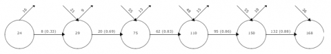
To realize the study's objectives, it is vital to understand the major themes and sub-themes of peri-urban planning, the literature search was initiated using the terms Peri-urban AND Planning within the titles, abstracts, and keywords in the web of science database on 24th May 2023. This has been done to comprehensively analyze the peri-urban field. As shown in Figure 1, the initial search resulted in 1,102 publications, of which only 924 papers were journal articles that have been included. Other publications such as reports, conference proceedings, and book chapters were excluded to maintain the uniformity of format across the articles reviewed. Further, only the articles published between 1991-2023 have been included in the review as this period is selected based on the start of continuous publications in the field from 1991, as found in the database; before 1991, there was discontinuity and low frequency in the published articles. Hence, after refining the period, the result yielded 891 articles, which were included. And only 882 publications were included based on language, i.e., English, as the paper serves a global readership. The next criteria for including papers are associated with the subject filter in WOS, i.e., only those articles under the subject of Urban studies, Geography, Panning and Urban Development, and Environmental Planning has been selected. These subjects directly cater to Planning domain and physical transformation of space which is essential as per the objectives of the paper and highlights the trade-odds within planning domain. This finally resulted in 622 total articles which have been included for conducting the analysis. The rigorous method for selection of final database will yield result that is focussed in the recent and relevant studies on planning of peri-urban areas and will illustrate the trends of associated network of other planning and development domains.
Figure 1. Methodology
2.2 Interpretation using VOSviewer and SciMat
To conduct the science mapping and bibliographic analysis, VOSviewer and SciMAT have been utilized. VOSviewer is employed to create bibliometric networks of significant keywords, journals, authors, and publications. These networks are constructed based on co-occurrence, bibliographic coupling, co-authorship, and co-citation analyses [11]. VOSviewer is chosen for analyzing the relationships because it provides a detailed view of the bibliometric map and is useful for achieving this study's objectives. The term co-occurrence analysis identifies significant study subjects and discerns key research clusters [12], efficiently visualizing large bibliometric maps that are easily understood.
SciMAT is another tool used with a longitudinal framework; it provides a mapping of domains, disciplines, articles, or authors correlated using co-word analysis, h-index, number of documents, and citations, etc., over different periods [13]. The analysis yields four different visualizations: (i) strategic diagrams, (ii) thematic networks, (iii) evolution maps, and (iv) overlay graphs [14]. A strategic diagram supports the thematic network by interpreting the relationship of and within themes [15]. The size of nodes indicates the number of documents published in the subject area, and the lines connecting nodes relate to the equivalence index [14]. Strategically displayed in a quadrant system, the diagram's horizontal and vertical axes represent network centrality and density, respectively, aiding in evaluating linkages between networks [15]. Network centrality concerns the degree of interaction within the network, while density measures the level of interactivity within a network. A theme with a higher centrality score has stronger external links to other themes and has contributed more to the field's growth and evolution. A topic with a higher density rating is more developed, with stronger internal links [12].
The two software tools have been used simultaneously to produce results that demonstrate the overall and period-wise development in the field of peri-urban planning and to justify the results. The first tool prepares the holistic bibliographic data based on co-occurrence, and the second tool assists in the evolution of themes and their inter-relationship, enhancing the comprehension of the overall theme as already elaborated in the studies [14, 16]. It is also noted that co-citation analysis is highly dependent on citation patterns, which may not accurately reflect the actual influence or significance of a work. Works that receive a high number of citations do not necessarily indicate the most influential or relevant research. Additionally, precise input data is required for VOSviewer, and a lack of bibliographic data can bias visualizations. While it provides accurate maps, the interpretation remains subjective to authors and readers. SciMAT visualizations can be complex, and the tool may require a level of expertise from researchers. In general, integrating VOSviewer and SciMAT is advantageous for gaining a comprehensive understanding of peri-urban planning. This combination allows researchers to explore both the intricate bibliometric connections and the longitudinal development of themes. Despite some limitations, the benefits of these tools in representing complex bibliographic data outweigh these drawbacks, making them vital in examining peri-urban development.
The section elaborates the outcomes of bibliometric analysis using VOSviewer in different formats such as the overall trend in the publication, term co-occurrence analysis, co-citation analysis, co-citation of authors, etc. In the second section, the analysis using SciMAT has been discussed. For the ease of understanding the evolution, the periods have been divided into six i.e., Period I (1991-1997), Period II (1998-2002), Period III (2003-2007), Period IV (2008-2012), Period V (2013-2017) and Period VI (2018-2023).
3.1 Overview of bibliometric analysis
This section will elaborate on the analysis using the tools and give insights into the bibliometric understanding of the literature on peri-urban planning.
3.1.1 Publication trends
The inconsistency in the overall publication can be observed in the frequency of published articles per year as mentioned in Figure 2. In periods I and II from 1991-2001, the number of articles is in similar numbers with an increase towards the end of the decade. However, there has been a gradual increase in period III and period IV from 2002-2011 with a slight decrease in the number of articles in a few of the years in between. And in period V and period VI, which are from 2012-2023, there is a sudden surge in the number of published articles in comparison with the previous years, with an exception from 2009 in which 32 articles were published. The increase in the number of published articles is consistent from 2020 to 2023. The worldwide phenomena of the Sustainable Development Goals (SDG) and The New Urban Agenda, which occurred over the previous two decades, have had a direct impact on publications, bringing fresh perspectives and aspects to the field of peri-urban planning.
Figure 2. No. of publications per year
3.1.2 Analysis of co-occurring term
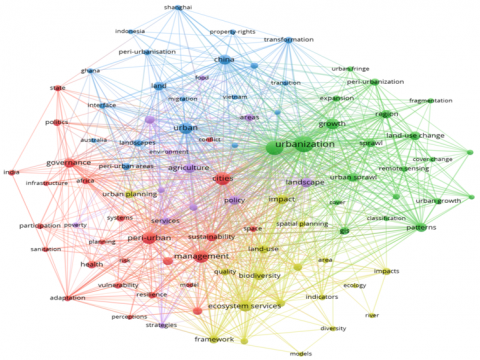
In the paper by Ding et al. [17], an analysis of Co-word was used to understand the pattern of relation keywords have and also analyze the trend in the usage from the papers of the database, where keywords from similar domains are put together in the cluster. And the node size represents the frequency of keywords published in different papers. The nodes which are distant from each other have lesser connections and proximate nodes are highly connected in literature [11]. The keyword co-occurrence of the database on peri-urban planning is given in Figure 3.
The co-occurrence of keywords in the database can be clustered into five. The first cluster in red color consists of 25 keywords including; ‘sustainability’, ‘management’, ‘governance’, ‘resilience’, ‘cities’, ‘vulnerability’, ‘participation’, and ‘infrastructure’. The association of these cluster words gives an insight into the issue of the institutional domain of peri-urban planning and the new emerging concepts of resilience and sustainability [18-20]. The second cluster consisting of 21 words focuses on the physical spread and transformation of the peri-urban areas with important keywords such as ‘urbanization, urban sprawl, remote sensing, land use change, urban fringe, GIS’ etc.
Figure 3. Term co-occurrence analysis
The third cluster has a total of 19 co-occurring keywords like ‘China, Indonesia, Shanghai, and Ghana’ with ‘landscape, property rights, migration’, etc. describing the majority of work being done time and again in these countries with the focus on the resource of land and the phenomenon associated for bringing transitions [21-24].
The fourth cluster in the network includes 18 keywords such as ‘ecosystem services, biodiversity, impact, ecology, indicator, spatial planning’, etc. which are relatively new terminologies with fewer connections in the network.
The fifth cluster of 12 words has less co-relation with other keywords in the network. The cluster includes words such as agriculture, food security, policy, etc. The word mostly used, as per the node sizes of the cluster, are ‘Urbanization, management, governance, cities, ecosystem services’ implying that most of the paper focuses on the phenomenon and its institutional structure since the first period.
However, if we analyse the papers in the last period, it can be seen that new words have now been added to the cluster such as ‘landscape planning, sustainable development, urban sprawl, cluster analysis, spatial metrics, climate change adaptation’, implying towards the shift in the dynamics of peri-urban literature [25-27]. The shift from focusing on urbanization in general towards the environmental aspects to cater to the multifunctionality of the space via different spatial metrics in place of indicators [28-30].
The observation reinforces the notion that it is now needed to use plan preparation, Master or Regional Plans, to look into the connections between the peri-urban space that a certain type of society has created, how that space has been used and changed, and what its current features and needs are [31]. We can think of peri-urban as a third space that exists on its own, not just as a result of rural areas becoming more urban or urban areas becoming less crowded.
3.1.3 Journals of prominence
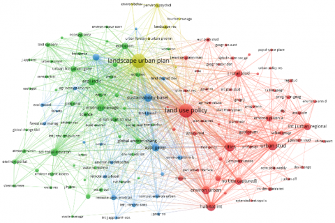
A co-citation is a reference to two sources; articles or publications, that are both mentioned in the same work [14]. This analysis of co-citation by sources gives an insight into the journals that have had a major influence in the field of literature are Land Use Policy, Landscape, and Urban Planning, Habitat International, Cities, Urban Studies, Applied Geography, Ecological Indicators, Science of the Total Environment. The analysis suggests that the journals publishing peri-urban studies can broadly be classified into four clusters forming the network of co-citation as shown in Figure 4. The red cluster, consisting of journals such as Land Use Policy, Habitat International, and Urban Studies, focuses mostly on urban planning and development in peri-urban areas. This cluster likely signifies a historical emphasis on the tangible and architectural elements of peri-urban areas. The green cluster, comprising periodicals such as the Journal of Environmental Management, Science of the Total Environment, and Ecological Indicators, emphasises a specific concentration on the environmental aspects of peri-urban areas. This signifies a growing acknowledgment of the ecological and sustainability factors in peri-urban development. Blue Cluster focuses on the integration of digital technologies with spatial systems. The blue cluster, which includes journals such as Remote Sensing, Applied Geography, Computer Environment, and Urban Systems, indicates a focused interest in the digital and spatial dimensions of peri-urban concerns. This cluster represents the amalgamation of technology and spatial analysis methods in comprehending and resolving peri-urban concerns. The fourth cluster, which includes journals such as Landscape and Urban Planning, Landscape Research, and Environmental Psychology, emphasises the interconnectedness of the environment, landscape, and human elements. Although this cluster exhibits a lower number of co-citations, the smaller sizes of the nodes may suggest the presence of emerging themes or more recent talks in peri-urban planning.
The inclusion of lower node sizes in the fourth cluster implies that Landscape and Urban Planning, Landscape Research, and Environmental Psychology might be relatively new contributions to the discussion on peri-urban planning. This suggests a potential change or broadening of the field's attention towards comprehending the complex connections among environment, landscape, and individuals. Moreover, the existence of a cluster that focuses solely on digital components, as exemplified by journals such as Remote Sensing and Computer Environment, indicates a modern aspect to peri-urban planning. The incorporation of these periodicals signifies an acknowledgment of the significance of technology and spatial analytic methods in tackling the difficulties faced by peri-urban areas.
Figure 4. Prominent publications
3.1.4 Prominent publication and authors
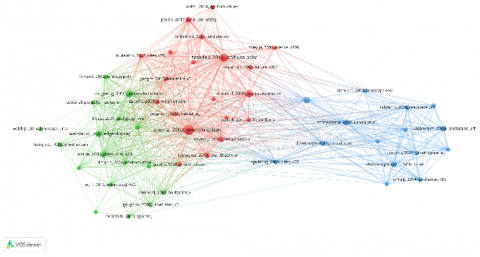
The publications with the most influence can be identified with the analysis of co-citations by references [13]. The most influential publications in the created database of peri-urban planning can be clustered into three groups as shown in Figure 5. The first one in red focuses on the publications in the core planning of the peri-urban area such as environmental planning, peri-urban farmlands, and agriculture, its rural-urban interface along with peri-urban project reports by the European Union [1, 2, 32-34]. The second cluster comprises the papers focused on the models of peri-urbanization such as Desakota, the physical transformation of peri-urban spaces, the effect of globalization in countries such as Ghana, China, Vietnam, and India [21, 23, 25]. The third cluster in blue color consists of papers mainly geared to cover the topics such as urban growth, pattern metrics, urban form, and morphology [35-38].
Figure 5. Co-citation analysis by references
It may be observed that the cluster in red and green are well connected whereas the cluster in blue seems to lack connections with the rest of the two. It might imply that research on peri-urban planning and related projects globally has not used the physical transformation aspect with the help of indices and metrics for evaluation, therefore, the physical transformation research is said to be done in a stand-alone entity (Figure 6).
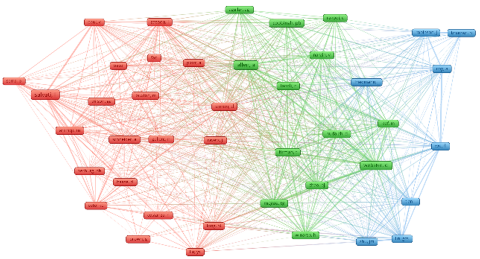
Figure 6. Co-citation anslysis by cited authors
The authors with the most influence can be identified by using a co-citation analysis of cited authors [14]. This analysis is in resonation with the previous analysis of co-citation by references. Allen, Patrick Cobbinah, Douglas Webster Tommy Firman, Vishal Narain, etc who focused on the aspect of environmental planning, impacts of urbanization, climate change, metropolitan phenomenon, sustainability, and its association with peri-urban areas. Another cluster in red comprised authors linked together like Luca Salvati, Annemarie Schneider, Marc Antrop, Richard Simon, and Ingo Zasada who have done studies related to urban form and growth, spatial assessment, landcover change, urban landscapes, etc. The blue cluster has fewer connections and authors such as Li Tian, Ananya Roy, Neil Brenner, and John Friedman with topics such as Integrated urban-rural development, ecosystem services, neoliberalism, regional planning, etc indicating a newer developing field of interest in urban planning, or less explored ones. The authors with the most citation in the cluster network can be found in Table 1.
Table 1. Most influential authors
|
S. No. |
Author |
No. of Citations |
Most Cited |
|
1 |
Luca Salvati |
135 |
[39] |
|
2 |
Adriana Allen |
92 |
[2] |
|
3 |
Douglas Webster |
79 |
[25] |
|
4 |
Ingo Zasada |
63 |
[40] |
|
5 |
Terry McGee |
57 |
[41] |
|
6 |
Marc Antrop |
55 |
[42] |
|
7 |
Ananya Roy |
54 |
[43] |
|
8 |
David Simon |
53 |
[1] |
|
9 |
Pattrick Cobbinah |
48 |
[44] |
|
10 |
Tommy Firman |
47 |
[45] |
3.2 Conceptual framework in the field of peri-urban planning literature
SciMAT software has been used to analyse the evolution of themes from 1991 to 2023. The following section discusses the evolution of literature and major themes and analyses the trends.
3.2.1 Conceptual framework of the period
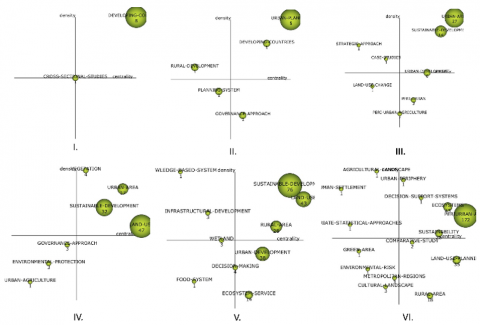
Using SciMAT, strategic diagrams have been developed for different periods as illustrated in Figure 7. The diagram is such that themes in one period are plotted on a quadrant system, in quadrant I, major themes are located, in quadrant II, the theme with significant development is put but the connections of these themes with the other theme of the period are less. In quadrant III, the themes on the emerging or declining side are placed, and in quadrant IV, the themes that have not been fully developed are basic [15]. The circle size in each of the strategic diagrams is proportional to the number of publications [14].
Figure 7. Strategic Diagram for periods. I 1991-1997, II. 1998-2002, III. 2003-2007, IV. 2008-2012, V. 2013-2017, VI. 2018-2023
Only two clusters were detected in the first period (1991-1997), developing nations and cross-sectional studies [46, 47], with higher centrality and density suggesting strong interaction. During this time, no further noteworthy clusters were found. Urban planning and developing nations remained key issues in the second decade (1998-2002), with urban planning demonstrating deeper links. Rural development developed as an emerging subject, but with little links to the planning system. The governance and environmental planning [48-50] method has grown in prominence in peri-urban planning, whereas the topic of developing nations has declined dramatically.
The third phase (2003-2007) strategy diagram revealed a significant growth in articles across quadrants. Sustainable development has arisen as a key concern, replacing urban expansion with deteriorating connectivity. The strategic approach and case studies have a low density and centrality. The emerging theme of land use change can be observed in quadrant III with significant publications like [51-53].
Articles on sustainable development and land use grew during Period IV (2008-2012), whereas urban area themes decreased. Land usage progressed from a minor to a significant subject cluster [10, 54, 55], but with few links. The density of vegetation motifs was high, indicating significant linkages. The governance method and environmental preservation were two new rising issues.
During Period V (2013-2017), land use and sustainable development research expanded [56-59], with more connections between and within cluster themes. Articles on knowledge systems, infrastructure development, and wetland development stood out but received fewer publications. Food system research began, while ecological services and urban development remained major issues.
During Period VI (2018-2023), the most sought-after study field was ecology in peri-urban regions, which was highly linked to other subjects. Sustainability publications have dropped, with an emphasis on certain sub-themes. There were minimal linkages between agricultural landscape and human settlement studies. The expanding literature on peri-urban landscapes and metropolitan regions predicted structural alterations in the future [60-63].
Over the years, there has been a shift towards more comprehensive and varied research methodologies, indicating a development in the subject. Researchers are using a wider range of methods to tackle the intricacies of peri-urban planning. The initial stages were marked by a concentration on core subjects such as urban planning and the advancement of underdeveloped countries. With time, there was a clear shift towards diversity and a more detailed comprehension of peri-urban environments. The topics identified in the later rounds demonstrate a reaction to developing concerns, with a specific focus on sustainability, ecology, and holistic approaches.
3.2.2 Advancements in the thematic cluster
The section elaborates on the dominant clusters identified in the literature on peri-urban planning and how it has evolved with time. It is also discussed how the sub-themes have interacted and transitioned during the periods within each cluster.
Sustainable Development
Initially, sustainable development in peri-urban planning was primarily linked to fundamental components such as land use, urban planning, and water resources throughout its early stages as illustrated in Figure 8. This initial phase entails a concentration on fundamental elements of sustainability, establishing the framework for future advancements. The complexity of sustainable development started from the period III; the sustainable development cluster demonstrated a tendency towards equitable planning by creating linkages with cultural landscape and peri-urban governance. This demonstrates an understanding of the significance of considering cultural and governance factors, as well as a notable grasp of the role of peri-urban agriculture. Throughout period IV and V, the field of peri-urban planning experienced significant advancements, which involved the integration of several components such as environmental management, informal settlements, and strategic planning, resulting in a more complex and sophisticated approach. The growth indicates a widening viewpoint, acknowledging the intricacy of peri-urban situations and the requirement for complete sustainable development strategies. In period V, the interaction between Sustainable Development Goals and characteristics like the rural-urban gradient demonstrates how both local and global influences affect peri-urban dynamics. This discovery questions beliefs regarding solely local influences and emphasises the interconnectedness of peri-urban planning with wider global sustainability objectives. In addition, peri-urban planning in period VI witnessed the emergence of sustainable development which encompassed the examination of trade-offs, regulatory frameworks, and environmental planning. The focus on the relationship between SDGs, environmental impact assessment, and the rural-urban gradient underscores the idea of glocalization, which refers to the combined impact of local and global influences on peri-urban activities.
Figure 8. Thematic network of sustainable development
The findings contradict beliefs regarding the apparent simplicity of sustainable development in peri-urban planning, exposing its complex character and the necessity for comprehensive methods. The progression towards a more all-encompassing methodology indicates novel paths in the discipline, urging scholars to investigate many domains of study and adopt glocalization in their analysis.
Land Use Planning
The investigation of the peri-urban literature's land use planning subtheme reveals unique tendencies across time, Figure 9. Land use change was a prominent subject throughout Period III, particularly regarding the peri-urban interface. The dominating study subjects were decision-making, landscape planning, and urban expansion in peri-urban regions. The interaction of issues such as land use conflict and governance, as well as the relationship between land use and ecosystem services, revealed a desire for accessible and conflict-free land development.
The investigation of land use planning underwent a shift as the inquiry advanced to phase IV. With the incorporation of words such as spatiotemporal, spatial analysis, urban sprawl, and remote sensing, spatial viewpoints and phenomena acquired relevance. This shift suggested an increased emphasis on charting the physical consequences of peri-urbanization and land use change. Furthermore, scholars began to dive into the knowledge of landscape structure changes, employing multivariate statistical approaches to elucidate the spatial dynamics and underlying causes of land use changes. A basic examination of land use change became clear to be insufficient, demanding the employment of comprehensive methodologies to capture the subtle spatial dynamics.
There was a clear shift in period V from focusing only on land use to a broader assessment of land use planning. This shift demonstrated a growing appreciation of the need of comprehensive methods. This era's thematic cluster of land use had a less sophisticated structure than the preceding period, but it included a broader range of themes.
The study in this subtheme has progressed dramatically, from a focus on land use change to including spatial dynamics, effects, and planning issues. To address the difficulties of land use in peri-urban environments, the trends emphasize the need for comprehensive approaches, spatial analysis, and multivariate tools. This paved the path for future studies to continue developing and addressing the issues connected with peri-urban land use planning, taking into account trade-offs, social elements, and geographical distribution.
Figure 9. Thematic network of land use'
3.2.3 Keywords and thematic evolution
Keyword and topic evolution analysis in the field of peri-urban planning literature gives significant insights into the shifting research scene. Overlay graphs, such as the one shown in Figure 10, provide a thorough perspective of the amount of keywords utilised over the research periods [12]. Keyword usage has increased significantly over time. Furthermore, the stability index shows that many keywords from the previous period stayed in the next period, with just a few phrases being changed or added. This indicates a degree of continuity and consistency in the study emphasis.
Figure 10. Keyword overlay graphs
Figure 11 depicts a thematic progression map that illustrates the dominant topics across the ages. Initially, the research was focused on urban planning and developing countries. However, as time passed, the topics emerged increasingly complex and diversified. The advent of sustainable development, land-use change, and the governance approach signalled a substantial shift in research interest. These themes gained momentum and began to include a larger variety of subjects, including peri-urban green spaces, environmental protection, and the significance of multivariate statistical approaches and decision support systems in peri-urban planning.
Figure 11. Thematic progression map
Thematic evolution also shows an increase in dimension, as the research extended to cover urban regions and addressed issues such as environmental services, agricultural landscapes, and cultural landscapes. This demonstrates a rising appreciation for the value of comprehensive and sustainable approaches to peri-urban design. The incorporation of technical tools and approaches such as GIS, spatiotemporal analysis, remote sensing, and spatial metrics demonstrates the growing importance of understanding urban form, land cover change, and spatial dynamics. The evolution of the research landscape from simplicity to complexity, the persistence of certain keywords, and the emergence of new thematic areas all implied towards the need to gain a deeper understanding of the growing research.
This paper's main goal was to undertake a thorough investigation of the patterns that were discussed often in the literature on peri-urban planning; key themes, facets, and research areas in this area while also looking at how these themes changed over time. The article also attempted to recognize the contributions made by authors in this field of research and offer readers a useful summary of the important published sources.
4.1 Synthesis from VOSviewer
The analysis of co-word clusters, co-citation networks, prominent publications, and influential authors reveals a shift towards environmental aspects, the field's interdisciplinary nature, the need for physical transformation evaluation, and the significance of sustainability, resilience, collaboration, and contextual considerations. Understanding these patterns and views is critical for furthering peri-urban planning research, guiding policy decisions, and attaining resilient and sustainable peri-urban development:
Although, the theme of land-use has accommodated several interconnected themes; Nevertheless, a considerably lower quantity of research has examined the paramount value of land and the procedure of its intervention. The studies fail to adequately examine the relationship between the planning mandate and the socio-spatial transformation [64-66]. Critical evaluation of the land development process that shapes and influences public functions and urban structures in peripheral areas.
4.2 Synthesis from SciMAT
The analysis of strategic diagrams, dominant clusters, and keyword trends reveals that the subject has advanced greatly over time, with an increasing emphasis on sustainability, land use planning, and the interaction of urban and peri-urban settings, confirming the results yielded in VOSviewer. Initially, the emphasis in developing countries was on urban planning, but this grew to encompass rural development, governance, environmental planning, and sustainable development. This finding implies that peri-urban regions are impacted by both local and global contextual elements, emphasizing the phenomena of glocalization. The relationship between the SDGs and numerous sub-themes emphasizes the intricate interplay between local and global forces. However, the literature suggests that both general trends of peri-urban development and the unique processes that happen in each case and changes that happen when these two types of development interact with each other is still needed to be researched [67].
Sub-themes such as land use change, knowledge systems, infrastructure development, and food systems emerged in subsequent eras, illustrating the increased complexity and variety of peri-urban planning studies. The land use planning cluster evolved from studying land use change to including spatial dynamics, consequences, and planning challenges, emphasizing the importance of comprehensive techniques and spatial analysis.
The theme progression was further assisted by keyword and theme evolution analysis. The use of keywords rose with time, showing an increase in research interest in peri-urban planning. The theme development map demonstrated the movement from basic to more complex and diverse issues, including peri-urban green areas, environmental protection, agricultural landscapes, and cultural landscapes. The use of technology tools and methodologies, such as GIS and remote sensing, emphasized the relevance of peri-urban planning in understanding urban form, land cover change, and spatial dynamics.
While the literature on peri-urban planning has grown over the years, it appears that there is a relative lack of attention on equitable spatial distribution. The equal distribution of facilities, green areas, housing, and secure transportation is critical for peri-urban growth. The lack of research and studies to enhance spatial fairness in peri-urban settings is apparent in the yielded domains and sub-themes.
The research also reveals a paucity of coverage of crucial areas in peri-urban planning literature, such as socio-spatial and economic elements. To inform policies and actions, it is required to dive deeper into social dynamics, economic possibilities, and problems of peri-urban areas. The investigation indicates that there is a lacuna of widely utilized and clear approaches for planning peri-urban regions, with GIS being the main option. The lack of comprehensive methodology impedes the creation of standardized frameworks and prevents cross-regional comparative investigations.
Although global phenomena such as neoliberalism, gentrification, quality of life, and the neo-rurality, peri-urban land management have a considerable influence on peri-urban regions, the study shows that these connections are generally absent from the literature. There are almost no studies investigating the linkages between peri-urban planning and wider global concerns which might give useful insights into the complexities and challenges that peri-urban regions confront [60]. The analysis does not specifically emphasize the incorporation of indigenous and local knowledge in peri-urban planning research. Local knowledge systems practices, and views provide important insights into the distinct qualities and difficulties of peri-urban communities.
The research also reveals a lack of attention on the assessment and evaluation of peri-urban planning strategies at neighbourhood scale [68]. Understanding the effects and efficacy of various planning initiatives is critical for evidence-based decision-making and policy creation; including the selection of drivers, metrics, and evaluation methodologies, to guarantee the effective and long-term implementation of peri-urban planning initiatives.
With all these nuanced studies, there is still a need for improvement in several areas; themes such as landscape structural changes, social elements of land usage, and trade-offs necessitate further in-depth investigation. Furthermore, the complexity of peri-urban land use planning underscores the need for more frameworks and techniques to handle land use difficulties and conflicts along with comparative studies in different regions which produced replicable results in similar context.
VOSviewer and SciMAT provide a complete peri-urban planning overview. VOSviewer indicates theme transitions, while SciMAT provides a longitudinal picture of the field's history. The conclusions are strengthened by the persistent emphasis on sustainability, land use planning, and urban-peri-urban interaction. Both tools show the field's development from fundamental to sophisticated concerns and can considerably inform policy-making, planning practice, and academic research in peri-urban settings. Policymakers can improve evidence-based decision making by understanding gaps and challenges that still exist and the relationship which are unexplored such as conducting studies to comprehend the institutional framework that governs land access in peri-urban areas. Additionally, to examine the motives and attitudes of the various actors towards the governance structure in order to facilitate effective planning and Understanding landscape structural changes, social land use, and trade-offs. The academic community can use these gaps to direct future research on peri-urban planning issues and solutions.
This study provides a comprehensive bibliometric overview of peri-urban planning's history and trends, highlighting key themes, research areas, and changes. Co-word clusters, co-citation networks, important publications, influential authors, and VOSviewer and SciMAT have revealed peri-urban planning insights. The findings highlight key peri-urban planning research trends and viewpoints. The research shows that authors now prioritise environmental issues over urbanisation, emphasising the need for sustainable and resilient peri-urban development. Peri-urban planning must balance various factors for sustainability. Land use, infrastructure expansion, and environmental preservation often require trade-offs. The bibliometric analysis shows a rising focus on environmental issues and sustainability, acknowledging the need to address trade-offs. Given the complexity of peri-urban challenges and the need to integrate knowledge from many sectors, collaboration and multidisciplinary methodologies have been stressed.
The analysis highlights the peri-urban planning literature's growing complexity and multidisciplinarity. It emphasises integrated methodologies, local and global consequences, and spatial analytic tools for peri-urban research. Despite advances, gaps and areas needing greater attention have been identified. Physical transformation and evaluation of peri-urban settings, equitable spatial distribution, socio-spatial and economic factors, and indigenous and local knowledge should be prioritised in planning processes. Planning professionals and researchers must understand methodology nuances for these studies. Planning for these changeable environments requires capacity building.
The study highlights standard frameworks, rigorous methodology, and spatial analytic technologies like GIS and remote sensing in peri-urban planning research. Landscape structural changes, social land use, trade-offs, and peri-urban planning's worldwide impact need more research. Peri-urban gentrification and land management are understudied, especially in developing cities were planning lacks standardised rules and conventions, preventing evidence-based decision making.
Filling these study gaps will improve our understanding of peri-urban development and its glocal concerns. In strategic diagrams, specialty areas of peri-urban planning like Green-Infrastructure, Neo-Rurality and Neo-Urbanism, Peri-urban Land Management, and others can be studied using bibliometrics. These new features must be addressed to create a holistic planning strategy and spatial indicators for a specific peri-urban neighbourhood. Policymakers can also prioritise resource allocation, focus on issues, and identify constraints that may be placed on peri-urban growth through multi-criteria decision making. Finally, this study contributes to peri-urban planning expertise by providing insights that might inform policy, research, and resilient and sustainable development as discussed in the following implications of the study.
[1] Simon, D. (2008). Urban environments: Issues on the peri-urban fringe. Annual Review of Environment and Resources, 33: 167-185. https://doi.org/10.1146/annurev.environ.33.021407.093240
[2] Allen, A. (2003). Environmental planning and management of the peri-urban interface: Perspectives on an emerging field. Environment & Urbanization, 15: 135-148. https://doi.org/10.1177/095624780301500103
[3] Rauws, W.S., De Roo, G. (2011). Exploring transitions in the peri-urban area. Planning Theory & Practice, 12: 269-284. https://doi.org/10.1080/14649357.2011.581025
[4] Woltjer, J. (2014). A global review on peri-urban development and planning. Journal of Regional and City Planning, 25: 1-16. https://doi.org/10.5614/jpwk.2014.25.1.1
[5] Mortoja, M.G., Yigitcanlar, T., Mayere, S. (2020). What is the most suitable methodological approach to demarcate peri-urban areas? A systematic review of the literature. Land Use Policy, 95: 104601. https://doi.org/10.1016/j.landusepol.2020.104601
[6] Legates, R., Hudalah, D. (2014). Peri-urban planning for developing east asia: Learning from Chengdu, China and Yogyakarta/Kartamantul, Indonesia. Journal of Urban Affairs, 36: 334-353. https://doi.org/10.1111/juaf.12106
[7] Huang, S.L., Wang, S.H., Budd, W.W. (2009). Sprawl in Taipei’s peri-urban zone: Responses to spatial planning and implications for adapting global environmental change. Landscape and Urban Planning, 90: 20-32. https://doi.org/10.1016/j.landurbplan.2008.10.010
[8] Wandl, A., Magoni, M. (2017). Sustainable planning of peri-urban areas: Introduction to the special issue. Planning Practice & Research, 32: 1-3. https://doi.org/10.1080/02697459.2017.1264191
[9] Aijaz, R. (2019). India’s peri-urban regions: The need for policy and the challenges of governance. Observer Research Foundation (ORF), 285: 1-12.
[10] Von Der Dunk, A., Grêt-Regamey, A., Dalang, T., Hersperger, A.M. (2011). Defining a typology of peri-urban land-use conflicts - A case study from Switzerland. Landscape and Urban Planning, 101: 149-156. https://doi.org/10.1016/j.landurbplan.2011.02.007
[11] Van Eck, N.J., Waltman, L. (2010). Software survey: VOSviewer, a computer program for bibliometric mapping. Scientometrics, 84: 523-538. https://doi.org/10.1007/s11192-009-0146-3
[12] Sharifi, A., Simangan, D., Kaneko, S. (2021). Three decades of research on climate change and peace: A bibliometrics analysis. Sustainability Science, 16: 1079-1095. https://doi.org/10.1007/s11625-020-00853-3
[13] Allam, Z., Sharifi, A. (2022). Research structure and trends of smart urban mobility. Smart Cities, 5: 539-561. https://doi.org/10.3390/smartcities5020029
[14] Sharifi, A. (2021) Urban sustainability assessment: An overview and bibliometric analysis. Ecological Indicators, 121: 107102. https://doi.org/10.1016/j.ecolind.2020.107102
[15] Cobo, M.J., Lõpez-Herrera, A.G., Herrera-Viedma, E., Herrera, F. (2012). SciMAT: A new science mapping analysis software tool. Journal of the American Society for Information Science and Technology, 63: 1609-1630. https://doi.org/10.1002/asi.22688
[16] Cui, X. (2018). How can cities support sustainability: A bibliometric analysis of urban metabolism. Ecological Indicators, 93: 704-717. https://doi.org/10.1016/j.ecolind.2018.05.056
[17] Ding, Y., Chowdhury, G.G., Foo, S. (2001). Bibliometric cartography of information retrieval research by using co-word analysis. Information Processing & Management, 37: 817-842. https://doi.org/10.1016/S0306-4573(00)00051-0
[18] Marshall, F., Dolley, J. (2019). Transformative innovation in peri-urban Asia. Research Policy, 48: 983-992. https://doi.org/10.1016/j.respol.2018.10.007
[19] Thapa, S., Marshall, F., Stagl, S. (2008). Understanding peri-urban sustainability: The role of the resilience approach. STEPS Working Paper 38, Brighton: STEPS Centre.
[20] Mpofu, G., Darkoh, M.K., Gwebu, T. (2018). Peri-urbanization landuse dynamics: An analysis of evolving patterns and their impacts on Gabane Village, Botswana. GeoJournal, 83: 725-741. https://doi.org/10.1007/s10708-017-9798-3
[21] Leaf, M. (2002). A tale of two villages globalization and peri-urban change in China and Vietnam. Cities, 19(1): 23-31. https://doi.org/10.1016/S0264-2751(01)00043-9
[22] Adam, A.G. (2015). Land readjustment as an alternative land development tool for peri-urban areas of Ethiopia. Property Management, 33: 36-58. https://doi.org/10.1108/PM-05-2013-0034
[23] Cobbinah, P.B., Amoako, C. (2012). Urban sprawl and the loss of peri urban land in Kumasi, Ghana. International Journal of Social and Human Sciences, 6: 388-397.
[24] Tian, L., Ge, B., Li, Y. (2017). Impacts of state-led and bottom-up urbanization on land use change in the peri-urban areas of Shanghai: Planned growth or uncontrolled sprawl? Cities, 60: 476-486. https://doi.org/10.1016/j.cities.2016.01.002
[25] Webster, D.R. (2001). On the edge: Shaping the future of peri-urban East Asia. Stanford University.
[26] Ahani, S., Dadashpoor, H. (2021). A review of domains, approaches, methods and indicators in peri-urbanization literature. Habitat International. 114: 102387. https://doi.org/10.1016/j.habitatint.2021.102387
[27] Rauws, W., van Dijk, T. (2013). A design approach to forge visions that amplify paths of peri-urban development. Environment and Planning B: Urban Analytics and City Science, 40: 254-270. https://doi.org/10.1068/b38040
[28] Wolff, S., Mdemu, M.V., Lakes, T. (2021). Defining the peri-urban: A multidimensional characterization of spatio-temporal land use along an urban-rural gradient in dar es Salaam, Tanzania. Land, 10: 177. https://doi.org/10.3390/land10020177
[29] Rajput, A.S. (2020). Peri-urban areas using spatial metrics: Case study of Indore. Nagarlok, LIII: 1-15.
[30] Sanches, P., de Oliveira, F.L., Celani, G. (2021). Green and compact: A spatial planning model for knowledge‐based urban development in peri‐urban areas. Sustainability, 13(23): 13365. https://doi.org/10.3390/su132313365
[31] Cattivelli, V. (2021). Planning peri-urban areas at regional level: The experience of Lombardy and Emilia-Romagna (Italy). Land Use Policy, 103: 105282. https://doi.org/10.1016/j.landusepol.2021.105282
[32] Ravetz, J., Fertner, C., Nielsen, T.S. (2013). The dynamics of peri-urbanization. In Peri-Urban Futures: Scenarios and Models for Land use Change in Europe. Springer-Verlag Berlin Heidelberg, pp 13-44.
[33] Tacoli, C. (2003). The links between urban and rural development. Environment & Urbanization, 15: 3-12. https://doi.org/10.1177/095624780301500111
[34] Paül, V., McKenzie, F.H. (2013). Peri-urban farmland conservation and development of alternative food networks: Insights from a case-study area in metropolitan Barcelona (Catalonia, Spain). Land Use Policy, 30: 94-105. https://doi.org/10.1016/j.landusepol.2012.02.009
[35] Schneider, A., Woodcock, C.E. (2008). Compact, dispersed, fragmented, extensive? A comparison of urban growth in twenty-five global cities using remotely sensed data, pattern metrics and census information. Urban Studies, 45: 659-692. https://doi.org/10.1177/0042098007087340
[36] Antrop, M. (2000). Background concepts for integrated landscape analysis. Agriculture, Ecosystems & Environment, 77: 17-28. https://doi.org/10.1016/S0167-8809(99)00089-4
[37] Chorianopoulos, I., Pagonis, T., Koukoulas, S., Drymoniti, S. (2010). Planning, competitiveness and sprawl in the Mediterranean city: The case of Athens. Cities, 27: 249-259. https://doi.org/10.1016/j.cities.2009.12.011
[38] Duvernoy, I., Zambon, I., Sateriano, A., Salvati, L. (2018). Pictures from the other side of the fringe: Urban growth and peri-urban agriculture in a post-industrial city (Toulouse, France). Journal of Rural Studies, 57: 25-35. https://doi.org/10.1016/j.jrurstud.2017.10.007
[39] Serra, P., Vera, A., Tulla, A.F., Salvati, L. (2014). Beyond urban-rural dichotomy: Exploring socioeconomic and land-use processes of change in Spain (1991-2011). Applied Geography, 55: 71-81. https://doi.org/10.1016/j.apgeog.2014.09.005
[40] Zasada, I. (2011). Multifunctional peri-urban agriculture-A review of societal demands and the provision of goods and services by farming. Land Use Policy, 28: 639-648. https://doi.org/10.1016/j.landusepol.2011.01.008
[41] McGee, T.G. (2015). The emergence of desakota regions in Asia: Expanding a hypothesis. In Implosions /Explosions. De Gruyter, pp 121-137.
[42] Antrop, M. (2005). Why landscapes of the past are important for the future. Landsc Urban Plan, 70: 21-34. https://doi.org/10.1016/j.landurbplan.2003.10.002
[43] Roy, A. (2005). Urban informality: Toward an epistemology of planning. Journal of the American Planning Association, 71: 147-158. https://doi.org/10.1080/01944360508976689
[44] Cobbinah, P.B., Erdiaw-Kwasie, M.O., Amoateng, P. (2015). Africa’s urbanisation: Implications for sustainable development. Cities, 47: 62-72. https://doi.org/10.1016/j.cities.2015.03.013
[45] Winarso, H., Hudalah, D., Firman, T. (2015). Peri-urban transformation in the Jakarta metropolitan area. Habitat International, 49: 221-229. https://doi.org/10.1016/j.habitatint.2015.05.024
[46] Browder, J.O., Bohland, J.R., Scarpaci, J.L. (1995). Patterns of development on the metropolitan fringe urban fringe expansion in Bangkok, Jakarta, and Santiago. Journal of the American Planning Association, 61: 310-327. https://doi.org/10.1080/01944369508975645
[47] Friedmann, J. (1996). Modular cities: Beyond the rural-urban divide. Environment & Urbanization, 8: 129-131. https://doi.org/10.1177/095624789600800107
[48] Adell, G. (1999). Theories and Models of the peri-urban Interface: A changing conceptural landscape. Development Planning Unit.
[49] Allen, A., Da Silva, N.L.A., Corubolo, E. (1999). Environmental problems and opportunities of the peri-urban interface and their impact upon the poor. Development Planning Unit. UCL: London, UK.
[50] Tacoli, C. (1998). Rural-urban interactions: A guide to the literature. Environment & Urbanization, 10: 147-166. https://doi.org/10.1177/095624789801000105
[51] Busck, A.G., Kristensen, S.P., Præstholm, S., Reenberg, A., Primdahl, J. (2006). Land system changes in the context of urbanisation: Examples from the peri-urban area of Greater Copenhagen. Geografisk Tidsskrift-Danish Journal of Geography, 106: 21-34. https://doi.org/10.1080/00167223.2006.10649554
[52] Hudalah, D., Winarso, H., Woltjer, J. (2007). Peri-urbanisation in East Asia: A new challenge for planning? International Development Planning Review, 29: 503-519. https://doi.org/10.3828/idpr.29.4.4
[53] Kombe, W.J. (2005). Land use dynamics in peri-urban areas and their implications on the urban growth and form: The case of Dar es Salaam, Tanzania. Habitat International, 29: 113-135. https://doi.org/10.1016/S0197-3975(03)00076-6
[54] Miljković, J.Ž., Crnčević, T., Marić, I. (2012). Land use planning for sustainable development of peri-urban zones. Spatium, 14: 15-22. https://doi.org/10.2298/SPAT1228015Z
[55] Tavares, A.O., Pato, R.L., Magalhães, M.C. (2012). Spatial and temporal land use change and occupation over the last half century in a peri-urban area. Applied Geography, 34: 432-444. https://doi.org/10.1016/j.apgeog.2012.01.009
[56] Westerink, J., Haase, D., Bauer, A., Ravetz, F., Aalbers, C.B.E.M. (2013). Dealing with sustainability trade-offs of the compact city in peri-urban planning across european city regions. European Planning Studies, 21: 473-497. https://doi.org/10.1080/09654313.2012.722927
[57] Arha, A., Audichya, R., Pant, D.C. (2014). Challenges in the urban and peri-urban transition zones and strategies for sustainable cities: Experiences from selected cities. In The Security of Water, Food, Energy and Liveability of Cities. Water Science and Technology Library. Springer, Dordrecht.
[58] Marcus, L., Colding, J. (2014). Toward an integrated theory of spatial morphology and resilient urban systems. Ecology and Society, 19(4): 55. https://doi.org/10.5751/ES-06939-190455
[59] Tian, L. (2015). Land use dynamics driven by rural industrialization and land finance in the peri-urban areas of China: “The examples of Jiangyin and Shunde.” Land Use Policy, 45: 117-127. https://doi.org/10.1016/j.landusepol.2015.01.006
[60] Gottero, E., Cassatella, C., Larcher, F. (2021). Planning peri-urban open spaces: Methods and tools for interpretation and classification. Land, 10(8): 802. https://doi.org/10.3390/land10080802
[61] Honeck, E., Moilanen, A., Guinaudeau, B., et al. (2020). Implementing green infrastructure for the spatial planning of peri-urban areas in Geneva, Switzerland. Sustainability, 12(4): 1387. https://doi.org/10.3390/su12041387
[62] Hedblom, M., Andersson, E., Borgström, S. (2017). Flexible land-use and undefined governance: From threats to potentials in peri-urban landscape planning. Land Use Policy, 63: 523-527. https://doi.org/10.1016/j.landusepol.2017.02.022
[63] Semeraro, T., Radicchio, B., Medagli, P., Arzeni, S., Turco, A., Geneletti, D. (2021). Integration of ecosystem services in strategic environmental assessment of a peri‐urban development plan. Sustainability, 13(1): 122. https://doi.org/10.3390/su13010122
[64] Wubie, A.M., de Vries, W.T., Alemie, B.K. (2020). A socio-spatial analysis of land use dynamics and process of land intervention in the peri-urban areas of bahir dar city. Land, 9: 1-27. https://doi.org/10.3390/land9110445
[65] Ahani, S., Dadashpoor, H. (2021). Land conflict management measures in peri-urban areas: A meta-synthesis review. Journal of Environmental Planning and Management, 64: 1909-1939. https://doi.org/10.1080/09640568.2020.1852916
[66] Wubie, A.M., de Vries, W.T., Alemie, B.K. (2021). Synthesizing the dilemmas and prospects for a peri-urban land use management framework: Evidence from Ethiopia. Land Use Policy, 100: 105122. https://doi.org/10.1016/j.landusepol.2020.105122
[67] Kleemann, J., Inkoom, J.N., Thiel, M., et al. (2017). Peri-urban land use pattern and its relation to land use planning in Ghana, West Africa. Landscape and Urban Planning, 165: 280-294. https://doi.org/10.1016/j.landurbplan.2017.02.004
[68] Sareen, S., Haque, M. (2023). The dynamics of peri-urban spatial planning : An overview. Journal of Urban Planning and Development, 149(3). https://doi.org/10.1061/JUPDDM.UPENG-4275