Madina Aitzhanova*![]() | Sayagul Zhaparova
| Sayagul Zhaparova![]()
© 2023 IIETA. This article is published by IIETA and is licensed under the CC BY 4.0 license (http://creativecommons.org/licenses/by/4.0/).
OPEN ACCESS
The relevance of the subject matter in this study is conditioned by a high degree of risk of spring floods in Akmola region, significant damage to the economy of the region and the need to develop and implement effective measures to counteract this natural situation. The purpose of the study is to develop a proper assessment of the environmental risk of spring floods and their consequences in the flooded areas of Akmola region. The methodological approach in this study is based on a combination of system analysis methods. They analyse the degrOctober 2023ee of probability of various kinds of environmental risks caused by spring floods and investigate the regularities of development of negative consequences of floods as a whole and in Akmola region of the Republic of Kazakhstan in particular. In the course of this study, findings have been made indicating the serious consequences of spring floods for economic activity in the areas affected by seasonal flooding of water bodies. The findings also indicate the need to develop and implement specific measures to prevent spring floods caused by serious disturbances to economic activity in water protection zones. The findings of this study and the scientific conclusions drawn from them are of significant practical significance for agricultural workers in Akmola region, who have to cope with the consequences of spring floods in the area where they operate.
natural disaster, ecology, flooding, seasonal overflow of water bodies, economic activity, flood management, water protection zones
Floods represent a significant threat to the livelihoods of any geographic region, as they cause significant disruption to the region's established way of life and cause widespread destruction, often involving loss of life. In this context, assessing the extent of environmental flood risks in a given area, combined with qualitative forecasting of the likelihood of these disasters, with a view to their possible prevention and management of the negative consequences of spring floods, is essential for the livelihoods of the region and its economic and social development [1].
A system for the regulation of areas and their inhabitants should include at its core the analysis of spring flood risks and the management of the processes causing them [2]. Overcoming the negative trend of an increasing number of floods in regions of human economic activity should be a priority for this system. In Western Europe, methods of state regulation of disaster risks have been introduced. This has already resulted in a significant reduction in the overall number of spring floods and other natural disasters. The advantage of introducing such methodologies lies in the real possibility of reducing the expenditure of material resources required to cope with the consequences of various natural disasters causing damage to economic activity by preventing them [3].
Flood risk analysis plays a key role in mitigating the adverse effects of floods on the economy, environment, and society by providing insights into potential hazards, enabling proactive planning, and guiding effective resource allocation. By understanding and managing flood risks, communities can minimize economic losses, protect ecosystems, and enhance overall societal well-being in the face of these natural disasters.
Modern methodologies for analysing the environmental risks of spring floods and preventing their possible consequences in flooded areas must be developed and implemented in strict accordance with the principles of risk theory, which is a scientific tool designed to support specific management decisions in various fields of human activity. In general, flood risk analysis is essentially the derivation of specific risk indicators for populations in particular geographical areas. It should necessarily include an assessment of the probability of the undesirable event occurring and the construction of the main impact factor fields with an assessment of their possible consequences [4]. Specific indicators, such as the size of the geographic area, the size and social composition of the population, the topography of the area, and the warning capability of the population about an impending disaster, should be considered. The latter factor should be given high priority, as a timely warning of an impending threat can significantly reduce the risks of negative consequences, even to the point of eliminating the risks of widespread destruction and loss of human life.
Floods are mainly caused by the intensive development of floodplains, with a basic disregard for the rules of economic activity in the areas where there is an increased risk of floods and water protection regions. Therefore, there is an increase in the total number of sites in the floodplain, with floods of identical height and water content leading to a gradual increase in both economic, social, and environmental damage [5].
The existing challenge in assessing the environmental risks of spring floods lies in the absence of a well-defined connection between the causal factors of these phenomena and their implications for economic activities, particularly amidst violations of economic norms within water protection zones. This study addresses this issue by seeking to establish a robust analytical correlation between the causal of spring floods in the Akmola region and the subsequent disruptions to economic activities in flooded areas. This research aims to deepen the comprehension of ecological risks linked with spring floods in the region. Thus, the central purpose of this study is to forge an analytical relationship between the causes of spring floods in the Akmola region and the ensuing economic and environmental ramifications, thereby enhancing the understanding and mitigation of associated risks.
In the research, the background on floods and their impacts, and the importance of assessing flood risks for prevention and management were provided. Then, in the materials and methods section, it was discussed the methodological approach, including using systems analysis methods to analyse flood risks and investigate patterns of flood impacts, supported by statistical data on the Akmola region. In the results section it was presented statistics on floods in the Akmola region, including on the Zhabai River. The impacts of floodwaters on soil conditions were discussed, as well as the main aspects of environmental risk assessment of floods in the region were summarized. Besides, the literature on assessing flood risks and damages was reviewed. Causes of flooding, forecasting services, estimation of economic damages, and approaches for reducing risks were discussed and different types of floods were compared. The main findings and conclusions, including that there is a high ecological risk from spring floods in the Akmola region which requires preventative measures, and floods have strongly negative impacts on soils were summarized.
This research employs a comprehensive methodological framework that combines system analysis methods to thoroughly comprehend and mitigate the environmental risks associated with spring floods. This approach integrates both quantitative and qualitative techniques for effective data collection, analysis, and interpretation.
To establish a robust foundation, statistical data is gathered from various dimensions of the Akmola region, encompassing geographical attributes, soil composition, population demographics, and economic activities closely tied to water bodies. This data forms the bedrock for subsequent analyses.
The quantitative assessment comes into play to gauge the likelihood of diverse environmental risks stemming from spring floods. By utilizing statistical tools such as probability distributions and modelling, the study quantifies the potential impact of flood events on the environment and society. This analytical process systematically evaluates the range of hazards linked with spring floods.
Qualitative methods complement the investigation by delving into the patterns of negative repercussions caused by floods. Drawing from case studies, historical flood data, and situational analyses, the study uncovers recurring trends in the aftermath of flood incidents. These qualitative insights offer a nuanced comprehension of the broader ramifications of spring floods within the Akmola region.
In addition, the study incorporates comparative analysis, juxtaposing its initial findings with existing flood risk assessment research. This step contextualizes the study's outcomes within the larger academic context, identifying areas of novelty and divergence.
The study unfolds through distinct phases. It commences by systematically constructing a theoretical framework that establishes the foundational requisites for qualitatively evaluating the ecological risks emanating from spring floods and their implications for economically significant flood-prone areas. This phase also includes a systematic evaluation of various environmental risks often tied to mismanagement in sectors such as agriculture.
Subsequent stages delve into the exploration of patterns underpinning the adverse consequences triggered by floods. Analysing statistical data related to flood incidents in the Akmola region, historical floods along the river Zhabai, instances of the house flooding in Atbasar town, and the influence of water on soil conditions in flooded regions enhances the understanding of environmental risks stemming from spring floods. These insights are further reinforced by comparative analyses with existing studies on ecological risks associated with such floods.
This research methodology seamlessly integrates quantitative tools, qualitative investigations, and comparative analyses to construct a comprehensive understanding of the environmental risks posed by spring floods in the Akmola region. This multi-faceted approach aims to offer a holistic perspective on the causes and consequences of these floods, ultimately contributing to the formulation of effective strategies for risk mitigation and sustainable flood management.
Despite the robust methodological approach adopted in this study, several limitations warrant consideration. Firstly, the findings' generalizability might be restricted due to the study's focus on the Akmola region of Kazakhstan. The unique geographical, climatic, and socio-economic characteristics of this region might limit the applicability of the results to other areas with differing contexts and flood dynamics.
Secondly, the study's comparative analysis with existing research might also carry limitations. The availability of relevant comparative studies, their methodologies, and the extent to which they align with this study's objectives could influence the comprehensiveness of this analysis. Biases arising from the selection of comparative studies or the limited scope of the existing literature could impact the overall contextualization of the findings. The inherent complexity of flood dynamics and the multifaceted nature of environmental risks might render some aspects of the study's analysis simplistic or reductionist. Certain intricacies within the causes and consequences of spring floods might not be adequately captured by the methodology employed, leading to an incomplete understanding of the ecological risks involved.
This research acknowledges limitations in terms of generalizability, data accuracy, potential biases, and the complexity of flood dynamics. While efforts were made to address these limitations, they underscore the need for cautious interpretation and consideration when applying the study's findings to other regions or contexts.
In the Republic of Kazakhstan today, approximately one-third of all emergencies that have occurred in recent years in the country are caused by floods. Akmola, Pavlodar, Karaganda, and East Kazakhstan regions should be considered the most prone to the impact of these natural phenomena, and the development of such situations is mainly caused by dam breaks and seasonal floods. In particular, between 2011 and 2015, there were 12 major floods in Kazakhstan, with over 1.750 houses in 40 villages flooded, with 47 people and over 350 livestock dead [6]. The total damages caused by floods throughout the Republic amounted to more than 250 million US dollars. Data from various sources, such as local newspapers or research by scientists, were collected and compiled by the authors in the form of figures and tables.
The Akmola region is located in the north of the Republic of Kazakhstan and has a sharply continental, arid climate. The Ishim River flows through the central part of the region, which has its right tributary, the Zhabai River. During spring snow melting and heavy precipitation, there is a seasonal outflow of waters from the Ishim River basin, including the Zhabai River. This causes flooding of towns and settlements located in the Ishim basin. Spring floods on the Zhabai River often cut off settlements from roads and highways.
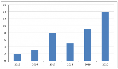
The main causes of spring floods on the Zhabai River in the Akmola region should be considered: abrupt melting of ice and snow; abrupt changes in temperature regime; abundant precipitation exceeding the average monthly norm for the region. Figure 1 presents statistical data on the number of floods in the Akmola region for the period 2015-2020.
Figure 1. Number of floods in the Akmola region for the period 2015-2020
Source: Composed by the authors
The settlements of Atsabar, Borisovka, Balkashino, Sandyktau, Novy Gorodok, Pokrovka, and Vladimirovka are located on the Zhabai River. The flow of water in the river is variable and distinctly seasonal. Differences in annual statistics regarding the amount of water in the river cause difficulties in the use of its resources for economic activities. In Atsabar, 2014 saw the largest flooding in the city's history at the time, when a dramatic snowmelt with temperatures rising to +15℃ led to intense meltwater run-off into the river Zhabai and flooding of 562 houses on 15 city streets. In 2017, the city's protection dyke was breached because of a sharp rise in the water level of the Zhabai River (6.2 metres against critical 3.5 metres). This caused over 450 houses to flood, prompting local authorities to evacuate 1,485 people as quickly as possible. The water level in the river was 2.7 metres higher than the critical value, with the flood level of 2014 being 90 centimetres higher.
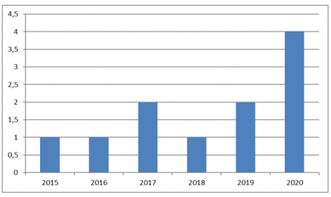
Figure 2 presents statistical data regarding the total number of floods on the Zhabai River in the Akmola region of the Republic of Kazakhstan for the period 2015-2020.
Figure 2. Statistical data regarding the number of floods on the Zhabai River in the Akmola region of the Republic of Kazakhstan for the period 2015-2020
Source: Composed by the authors
As shown in Figure 2, the largest number of floods on the Zhabai River was recorded in 2020, and the extent of flooding in the surrounding area is not statistically comparable with the April 2017 flood.
The impact of flood water on soil conditions in the flooded area is generally negative and is expressed in the following aspects:
Table 1 summarises the main statistics regarding the main physicochemical characteristics of flood-disturbed and undisturbed soils in the areas affected by floods.
Table 1. Basic physical and chemical characteristics of flood-disturbed and undisturbed soils in regions subject to flooding
|
Stage of Degradation |
Horizon |
Power |
pH |
Humus % |
Saturation % |
HA, Mole/100g |
Schwertman Ratio |
Bogedom Ratio |
|
Undisturbed cryogenic soil |
Ca |
0-22 |
4.2 |
44.8 |
16.5 |
155.0 |
- |
- |
|
Bg |
14-39 |
5.4 |
0.86 |
48.2 |
4.7 |
0.75 |
0.04 |
|
|
Weak degradation |
Ca |
8-24 |
4.8 |
1.88 |
25.5 |
33.7 |
0.74 |
0.15 |
|
Bg |
25-87 |
5.7 |
1.84 |
68.6 |
4.2 |
0.77 |
0.06 |
|
|
Average degradation |
Ca |
0-7 |
5.3 |
25.4 |
32.3 |
45.5 |
- |
- |
|
Bg |
7-98 |
5.1 |
3.9 |
36.6 |
15.5 |
0.82 |
0.14 |
|
|
Severe degradation |
Ca |
6-24 |
5.6 |
1.7 |
55.8 |
67.2 |
0.81 |
0.1 |
|
Bg |
22-73 |
5.0 |
4.4 |
28.7 |
14.4 |
0.91 |
0.12 |
Notably, soils at the first stage of degradation tend to recover quickly if there is a relative drought after flooding, when comparing the characteristics of soils undisturbed by floods and those in different stages of degradation. Furthermore, the hydrological characteristics of the soil, with a clear structure and colour change of the soil cover, and a reduction in viscosity are observed when the soil is thawed out. There is a significant over-wetting of the poorly and severely degraded soils, resulting in a significant increase in its thawing depth, by an average of 50-90 centimetres [7]. There is also a weak saturation of soils of all types with grounds, indicating a shift of the saturation distribution maxima to the upper part of the soil profile.
The following aspects should be considered when forming an environmental risk assessment of spring floods and their consequences for flooded areas in the Akmola region of the Republic of Kazakhstan:
Floodwaters annually cause considerable material damage to settlements in the Akmola region, while significantly worsening the ecology of the region's soils. In some cases, the restoration of soils after the negative impact of floods takes a considerable amount of time and requires significant material budgetary resources [8].
The results revealed that floods pose a major threat to Kazakhstan, especially in the Akmola region, causing substantial damage. Analysis showed spring floods in the Akmola are driven by seasonal snowmelt, rainfall, and temperature fluctuations. Along the Zhabai River, floods have been steadily rising and severely impacting local settlements through inundation. These floodwaters adversely alter soil composition and structure, jeopardizing agricultural viability and ecological stability in flooded areas. Besides, restoration of such flood-damaged soils proves extremely challenging. These findings underscored the need for comprehensive flood risk assessment incorporating regularity, damage, and restoration requirements, alongside preventative actions like regulation compliance for water management. The research highlighted the escalating dangers of recurring seasonal flooding across the Akmola region, quantifying the considerable harm inflicted on communities and environments. It also emphasized the difficulty of rehabilitation and the necessity of holistic flood risk frameworks and proactive mitigation measures to minimize human, economic, and ecological impacts. This provided an evidentiary foundation to develop integrated flood management strategies that reduce community vulnerability, safeguard agricultural soils, and mitigate flood proliferation in floodplain ecosystems. The ecological risk from floods can be effectively and objectively determined after a considerable period of time to objectively assess the damage caused and the time required to restore damaged soils to their original condition. Special attention must be paid to compliance with the rules for the use of natural resources directly in flood areas and the safety regulations for handling hydraulic structures. Emergency situations in these areas can also result in large-scale flooding and considerable material and environmental damage to the surrounding area's economic structures.
Floods are significant flooding of an area caused by a sudden rise in the level of water in rivers or other water bodies adjacent to the area. Floods pose a particular danger when the flooding of area results in significant material damage, endangers the life and health of the people living in the area and causes significant disruption of agricultural activities in the areas affected by flooding. Assessing the degree of environmental risk posed by floods and spring floods is essential for predicting the development of the ecological situation in a given geographical region [9]. Until recently, effective solutions to the problems associated with protecting people and places from emergencies have involved finding and implementing ways and means of dealing with the consequences of such situations. Such efforts are very costly and entail a considerable amount of time and money, and the effectiveness of such efforts is often inadequate. The resources available, which are often very limited, should be focused on reducing the likelihood of various threats and risks, and on dealing with the possible consequences of emergencies [10].
The causes of springtime flooding in rivers are often caused by significant constriction of the river floodplain by bridges, road and railway embankments, and the construction of industrial structures in the floodplain. As a result, there is a reduction in the capacity of rivers and a build-up of water mass in the upstream areas directly during floods, which results in an increase in the total flooded area and substantial material damage. Furthermore, there is a strong correlation between high failure rates of hydraulic structures and flooding in specific geographical areas, which causes significant economic problems [11]. Compliance with the rules for economic activities in water protection areas minimises the risk of flooding and increases the frequency of spring floods, which is the key to successful economic activity in the region.
The increase in the total number of natural disasters, the economic and environmental problems they cause, the problems of life safety, and the sustainable development of the areas where economic activities are carried out have gained considerable relevance. This is in the context of the quality of economic planning and the increased social responsibility for the economic decisions made. Studies of the causes and consequences of hazardous processes that have a direct impact on human livelihoods represent a promising area of study for addressing the risks of economic activities in different geographical regions and economic sectors [12].
Among the variety of natural disasters affecting economies worldwide, floods are the most common, accounting for approximately 33-35% of the total number of disasters occurring in a single calendar year. Floods cause economic losses in dozens of countries worldwide annually, and there has been no downward trend in the risk of floods and similar disasters even in the developed world over the past few years [13].
Every year, spring floods inundate thousands of hectares of land around the world, leaving thousands of houses in flooded areas, destroying grain crops and a number of other crops. Hundreds of kilometres of roads and railways are also damaged, leading to considerable economic losses. The establishment of a forecasting service for the occurrence and development of natural situations of this kind helps to reduce the effects of natural disasters and to monitor situations directly related to human economic activity that leads to an increased risk of floods and inundation.
Often official information regarding the level of economic damage caused by natural disasters, floods, etc. should not be perceived unconditionally. This is usually explained by the fact that direct damage, caused by direct contact of flood waters with economic objects or the land on which economic activities take place, is considered [14]. In relatively rarer cases, indirect damage is considered, which is mainly caused by losses from disrupted economic relations, falling economic output, and problems with banking and business operations.
The serious economic and environmental damage caused by floodwaters to the economic activities of the flooded areas and to the soils in the flood zone requires intensified investigation into the potential flood hazards to lands in the spring flood areas and to the entire inundated area. Moreover, studies should address the issues of providing organisational and practical measures to reduce the risk of the occurrence of problematic situations, both natural and man-made [15]. There should be a practical methodology for determining the extent of economic damage under different emergency conditions at reservoirs adjacent to inundation sites.
Floods that result in significant flooding are caused by considerable rises in water levels during spring floods, ice jams, wind-driven surges, and man-made accidents involving the bursting of lakes, hydraulic structures, or the etching of water masses [16-18]. Consideration should be given to the fact that floods are relatively short-lived rises in river water levels caused by the melting of snow masses with the onset of spring thaw, and also by heavy and intensive rainfall and the drawing of water from the reservoir. Seasonal floods occur annually at the same time of year, are rather long-term processes and significantly increase the water content of the rivers, which results in a rise in their level.
The consequences of spring floods, inundations, and floodwaters are negative and extensive, and they cause significant direct and indirect damage to the economic activities of flooded areas. Indirect and direct losses from natural disasters can be expressed both in terms of damaged infrastructure in flood areas, destroyed residential and public buildings, destruction of economic crops, deterioration of agricultural soil quality, and in terms of human casualties, loss of life, and injuries among the population. Furthermore, indirect damages can include a significant reduction in the economic development of flooded regions, a decline in the living standards of the bulk of the population, and the high material costs of post-disaster recovery and reconstruction of the destroyed economy [19, 20].
Today, a system has been adopted to determine the degree of flood danger and the extent of an impending emergency by comparing the level of river rise with its nominal level. The total flooded area has a direct relation to the greatest level of water rise in the river when the surrounding area is flooded. It is possible to assess the prospects for overcoming an emergency situation caused by a river overflow and flooding, depending on the rate at which the floodwaters recede.
Over the last few decades, there have been steady upward trends in losses from floods, even though extensive flood protection measures have been implemented. A similar situation occurs during relatively minor and typical flood events. Among the main reasons for this are: the progressive reduction in the capacity of drains to accumulate water masses due to numerous anthropogenic phenomena, such as large-scale deforestation, drainage of wetlands, and the erosion of river floodplains by hydraulic structures; the large-scale use of areas at risk of flooding for economic purposes; the increase in the total number of floods caused by purely man-made factors, in particular accidents at water intake facilities; the significant reduction in the overall number of activities aimed at flood prevention and mitigation as a result of drastic cuts in funding [21-25].
According to current economic calculations, when there is a flood with about 1% of annual precipitation, an area of up to 1,405,000 ha is flooded, at least one-third of which, according to rough statistical calculations, is agricultural land. The flooded area will cover several hundred settlements, with the entire population. Spring floods are caused by a sudden rise in the water level of rivers, high rainfall, and melting snow. A timely assessment of the likelihood of flooding in a given geographical area can provide an opportunity for timely assessment of the situation and preparation for a set of measures to prevent its development, which can significantly reduce the level of economic damage from flooding [26].
The development of a system for assessing the potential extent of a spring flood and its hazard to economic activity in a geographical region identifies the most hydrologically hazardous areas of the country. This can be used to further assign these areas to specific zones, determining the potential scale of an emergency event in each area, and generating a rough estimate of the expected consequences, both economic and social. It is also important to assess the level of environmental risks posed by the spring flooding as a consequence of disrupting the ecological balance of the region and creating a potential hazard for future economic activity.
The general conditions for the occurrence and development of floods and inundations determine the possibility to categorise floods into several main groups. In particular, these include floods caused by seasonal snowmelt and a significant increase in water flow from this melting, occurring annually at approximately the same time and called seasonal floods; floods caused by heavy rainfall, and also by heavy rainfall combined with simultaneous snowmelt in flooded regions, called flash floods; and also floods caused by significant resistance to the flow of water in a river when large amounts of ice accumulate in one place [27, 28]. The parameter of water level rise compared to the conventional water level in the reservoir, which is called "zero hydrological rise", should be considered the main characteristic of the flood that defines directly the nature of its flow. The flow rate in a flood is the total amount of water flowing through a riverbed per second.
The key characteristics of any river's water regime, such as flow and level, undergo constant changes over time. In the particular river section under consideration, the water level in the river is directly dependent on the flow rate, with the water level itself being set automatically, to the extent necessary to pass a given water mass [29]. The relationship between flow rate and water level can be expressed graphically, by measuring a series of initial parameters and determining the dynamics of their change. Such a relationship is called a hydro-stock and is one of the key characteristics of a river when considering it in detail. It is essential in determining the nature of the development of a flood or seasonal flood caused by a rise in the water level of a river [30, 31].
The study conducted to assess the environmental risk of spring floods and their consequences in flooded areas of the Akmola region has led to the following conclusions.
The flooding of areas in the Akmola region, caused by the onset of seasonal spring floods, results in significant damage to economic activities, and this damage is expressed both in material terms and in disruption of the ecological situation in the region as a whole. Floods have a negative impact on the soil cover, causing soil erosion and significantly reducing the duration of their use for agricultural purposes. All this indicates that there is a high degree of risk of deterioration in the overall ecological situation of the region in the case of spring floods and the need to develop and put into practice a set of measures to prevent their occurrence. In this context, particular attention should be paid to safety in the operation of hydraulic structures, as accidents directly or indirectly related to dam breaks are often responsible for the occurrence of leaks and have serious negative consequences for the environmental situation in the region.
Floods have an extremely negative impact on the state of the soil cover of the Akmola region, actually contributing to the washout of soils suitable for agricultural activities. This situation affects both the flood areas themselves and neighbouring areas because, as noted above, it contributes to the deterioration of the ecological situation in the region as a whole. At the same time, the efforts to restore the soil cover to its original state and rehabilitate its fertility are lengthy and costly. The ecological risk of spring floods and their consequences over flooded areas of the Akmola region should be recognised high, which necessitates the search for effective ways to prevent the onset of spring floods as natural disasters capable of significantly worsening the ecological situation in this region of the Republic of Kazakhstan.
However, while this study provides important insights into flood risks for the Akmola region, there are some limitations to note. The exclusive focus on the Akmola region may restrict the generalizability of the findings to other geographic areas where flood dynamics may differ. Future research could expand the spatial scope to assess flood risks across multiple regions of Kazakhstan for comparison. In addition, the relatively small sample size of analysed flood events, limited to a few years, makes robust risk modelling challenging. More data over longer timescales could enable a better understanding of flood probability patterns. Besides, the qualitative assessments of economic, ecological, and health impacts lack precise quantification that more detailed impact data could provide. Finally, the proposed policy regulations face practical implementation constraints including political, economic, and technical feasibility. These limitations are typical for a focused regional-scale analysis, but they highlight opportunities for expanding the research in future work through broader spatial scope, expanded datasets, quantitative impact measurement, and factoring implementation challenges. Thus, this research represents an important step forward despite these limitations, but further research building on these findings could offer critical progress in flood risk mitigation.
[1] Grantham, T.E., Matthews, J.H., Bledsoe, B.P. (2019). Shifting currents: Managing freshwater systems for ecological resilience in a changing climate. Water Security, 8: 100049. https://doi.org/10.1016/j.wasec.2019.100049
[2] Adams, T.E., Pagano, T.C. (2016). Flood Forecasting: A Global Perspective. Academic Press.
[3] Brody, S., Lee, Y., Kothuis, B. (2021). Coastal Flood Risk Reduction. Elsevier, Oxford, UK.
[4] Li, Z., Husein, M., Hemmati, A. (2021). Foam flooding and gas injection methods. Woodhead Publishing, Oxford, UK.
[5] Madhav, S., Kanhaiya, S., Srivastan, A., Singh, V., Singh, P. (2021). Ecological Significance of River Ecosystems. Academic Press, London, UK.
[6] Radio Azattyk. (2019). Chronicle of major flooding in Kazakhstan. https://rus.azattyq.org/a/29807955.html.
[7] Chaiechi, T. (2020). Economic Effects of Natural Disasters. William Andrew, Norwich, UK.
[8] Vinet, F. (2017). Floods. Academic Press, London, UK.
[9] Simonov, V.V., Osadchy, O.V. (2014). The nature of floods, floods and characteristics of their damaging factors. Scientific and Educational Problems of Civil Protection, 1: 9-19. https://cyberleninka.ru/article/n/priroda-vozniknoveniya-navodneniy-zatopleniy-i-harakteristika-ih-porazhayuschih-faktorov/viewer.
[10] Kusainov, A.B. (2015). Analysis and assessment of the risk of hydrological hazards in the territory of the Karaganda region. Problems of Ensuring Safety in the Elimination of the Consequences of Emergency Situations, 8: 39-42. https://cyberleninka.ru/article/n/analiz-i-otsenka-riska-gidrologicheskih-opasnyh-yavleniy-na-territorii-karagandinskoy-oblasti/viewer.
[11] Krausmann, E., Cruz, A., Salzano, E. (2016). Natech Risk Assessment and Management. Woodhead Publishing, Oxford, UK.
[12] Bahrami, G., Noroozi, M., Shakiba, A., Rafiey, H., Sajjadi, H. (2020). The relationship between dysentery and climatic parameters in Iran. Urban Climate, 34: 100697. https://doi.org/10.1016/j.uclim.2020.100697
[13] Lutoff, C., Durand, S. (2018). Mobility in the Face of Extreme Hydrometeorological Events 1: Defining the Relevant Scales of Analysis. Elsevier.
[14] Gerlitz, L., Vorogushyn, S., Gafurov, A. (2020). Climate informed seasonal forecast of water availability in Central Asia: State-of-the-art and decision making context. Water Security, 10: 100061. https://doi.org/10.1016/j.wasec.2020.100061
[15] Schumann, G. (2021). Earth Observation for Flood Applications. Elsevier, Oxford, UK.
[16] Ullah, H., Rashid, A., Liu, G., Hussain, M. (2018). Perceptions of mountainous people on climate change, livelihood practices and climatic shocks: A case study of Swat District, Pakistan. Urban Climate, 26: 244-257. https://doi.org/10.1016/j.uclim.2018.10.003
[17] Zhalgassuly, N., Estemesov, Z.A., Kogut, A.V., Ismailova, A.A., Darmenkulova, A.B. (2020). Chemical and mineralogical characteristics of technogenic raw materials of mining enterprises of Kazakhstan. International Multidisciplinary Scientific GeoConference: SGEM, 20(5.1): 139-148. https://doi.org/10.5593/sgem2020/5.1/s20.018
[18] Tyliszczak, B., Drabczyk, A., Kudłacik, S. (2016). Comparison of hydrogels based on commercial chitosan and Beetosan® containing nanosilver. Molecules, 22(1): 61. https://doi.org/10.3390/molecules22010061
[19] Darnthamrongkul, W., Mozingo, L.A. (2020). Challenging anthropocentric stormwater management: Advancing legislation for environmental sustainability in the United States. Water Security, 10: 100064. https://doi.org/10.1016/j.wasec.2020.100064
[20] Mero, G., Skenderasi, B., Shahini, E., Shahini, S., Shahini, E. (2023). Main directions of plants integrated protection in the conditions of organic agriculture. Scientific Horizons, 26(3): 101-111. https://doi.org/10.48077/SCIHOR3.2023.101
[21] James, L.D., Shafiee-Jood, M. (2017). Interdisciplinary information for achieving water security. Water Security, 2: 19-31. https://doi.org/10.1016/j.wasec.2017.10.001
[22] Komilova, N.K., Rakhimova, T., Allaberdiev, R. Kh., Mirzaeva, G.S., Egamberdiyeva, U.T. (2021). Ecological situation: The role of education and spirituality in improving health of population. International Journal of Health Sciences, 5(3): 302-312. https://doi.org/10.53730/ijhs.v5n3.1512
[23] Golubev, V.G., Filin, A.E., Agabekova, A.B., Taimasov, B.T., Janpaizova, V.M., Kenzhibayeva, G.S., Suigenbayeva, A. Zh., Iztleuov, G.M., Botabayeva, R.Y., Zhunisbekova, D.A., Kutzhanova, A.N., Shapalov, Sh. K., Ramatullayeva, L.I., Suleimenova, T.N., Utenov, N.M., Akilov, T.K., Kolesnikov, A.S. (2022). Mathematical description of the process of film condensation of vapors from steam-gas mixtures. Rasayan Journal of Chemistry, 15(3): 1905-1915. http://doi.org/10.31788/RJC.2022.1536695
[24] Vakal, A., Lytvynenko, Y. (2023). Rare phytodiversity of the Ivotka river basin within the territory of the Sumy region. Ukrainian Journal of Forest and Wood Science, 14(2): 21-37. https://doi.org/10.31548/forest/2.2023.21
[25] Asgerov, E.B., Beskrovnyy, A.I., Doroshkevich, N.V., Mita, C., Mardare, D.M., Chicea, D., Lazar, M.D., Tatarinova, A.A., Lyubchyk, S.I., Lyubchyk, A.I., Doroshkevich, A.S. (2022). Reversible martensitic phase transition in yttrium-stabilized ZrO2 nanopowders by adsorption of water. Nanomaterials, 12(3): 435. https://doi.org/10.3390/nano12030435
[26] Barandun, M., Fiddes, J., Scherler, M., Mathys, T., Saks, T., Petrakov, D., Hoelzle, M. (2020). The state and future of the cryosphere in Central Asia. Water Security, 11: 100072. https://doi.org/10.1016/j.wasec.2020.100072
[27] Eichelberger, L., Hickel, K., Thomas, T. K. (2020). A community approach to promote household water security: Combining centralized and decentralized access in remote Alaskan communities. Water Security, 10: 100066. https://doi.org/10.1016/j.wasec.2020.100066
[28] Ryskaliyeva, A.K., Baltabayev, M.E., Abaeva, K.T. (2019). Regularities of enthalpies of combustion of nitrogen-containing organic compounds. Journal of the Chemical Society of Pakistan, 41(3): 531-534. https://go.gale.com/ps/i.do?id=GALE%7CA591700149&sid=googleScholar&v=2.1&it=r&linkaccess=abs&issn=02535106&p=AONE&sw=w&userGroupName=anon%7Eedb2726e&aty=open-web-entry
[29] Abdel Rahman, M.A.E., Natarajan, A., Srinivasamurthy, C.A., Hegde, R. (2016). Estimating soil fertility status in physically degraded land using GIS and remote sensing techniques in Chamarajanagar district, Karnataka, India. The Egyptian Journal of Remote Sensing and Space Science, 19(1): 95-108. https://doi.org/10.1016/j.ejrs.2015.12.002
[30] Korneychuk, N. N., Kirichuk, G. Y. (2018). Structural and functional organization of phytomicroperiphyton of the transboundary stviga river. Hydrobiological Journal, 54(1): 3-18. https://doi.org/10.1615/HydrobJ.v54.i1.10
[31] Shcherbak, V.I., Korneychuk, N.N. (2006). Contour algae communities of stones of the Teterev river downstream of the town of Zhitomir in various seasons. Hydrobiological Journal, 42(1): 40-46. https://doi.org/10.1615/HydrobJ.v42.i1.30