Mahmood Kh. M. Alabaachi*![]() | Emad Hani Alalaf
| Emad Hani Alalaf![]()
© 2023 IIETA. This article is published by IIETA and is licensed under the CC BY 4.0 license (http://creativecommons.org/licenses/by/4.0/).
OPEN ACCESS
The historic centers of cities have shifted during the last period into economic and commercial centers; this change has made them lose their distinct urban identity since these commercial centers need a flow of traffic, and these fabrics cannot absorb such an intensity of traffic. The objective of the research is to assess the possibility of possessing the historic urban fabric of the city of Mosul with the capabilities and urban features to accommodate sustainable transportation systems within, reduce dependence on individual vehicles, and give the fabric capabilities for preservation and development. The study uses an analytical comparison of international sustainable transportation evaluation systems to identify the most vital indicators: accessibility, permeability, and internal connectivity. The spatial structure of Mosul's historic city center is analyzed using space syntax theory, UCL Depthmap 10, AutoCAD 2016, and ArcMap 10.8 to evaluate how it performs on these indicators. The results showed a high internal connectivity values for the fabric reaching 344 intersections/km², with high integration values for the main circulation axes reaching (1.89) and their local control values reaching (2), with high coverage rates for service as crossing axes for the fabric reaching (83%). In conclusion, the study concluded that the historical urban fabric of the city of Mosul possesses the necessary urban structure and features that qualify it for sustainable transportation systems to work effectively within it.
the sustainable city, sustainable transportation, historic cities, urban development, engineering standards and indicators, urban fabric, space structure
Historic urban areas are considered an essential part of local culture and a base for cultural tourism and local community prosperity, and rely mainly on walking mode to move within their fabrics [1]. The Urban form according to urban fabric theory, depends on the type of transportation mechanisms used within the urban fabric [2]. These urban fabrics in traditional cities characterized by a high-density, and diversity mixed activities such as shopping, education, and public transportation combined with the activity of walking, as they were socially and environmentally sustainable [3]. The Pedestrian environments were neglected in modern urban design while the car dominating transportation during the first half of the last century, so the individual vehicles in present dominate on the urban space of the city [4]. The urban form of the city directly affects the environmental footprint of the city. The walking fabric has the ability to improve the efficiency of the urban fabric by technology and innovation in construction, approximately thirty times compared to the urban fabric of traditional urban fabrics car [5]. New planning laws began to appear in cities of Middle East that depend on the geometric grid pattern after World War II, containing shallow spaces that can be accessed directly which affected on transportation modes type used in these fabrics, thus casting shadows on the historical fabrics [6]. These historical centers were transformed into commercial centers as a result of the economic developments that the cities witnessed in recent decades due to their structural characteristics that facilitate access to them, which made them carry traffic capacity that their urban spaces could not provide, which negatively affected on the form of these fabrics [7]. Development based on sustainability standards for historic cities is required, for the purpose of preserving the heritage values possessed by these fabrics, which contain within them tangible and intangible heritage values, and granting them the potential for economic, tourism and commercial development by reducing dependence on individual vehicles for transportation [8]. Based on the historical lessons from the most beautiful and successful cities, new urban approaches emphasize the appeal of compact, mixed, walkable and relatively self-sufficient communities [9]. The historic city of Mosul has major circulations axes with high integration that can be used in the process of generating cultural axes with different activities at the level of the city of Mosul, and by relying on the efficiency and diversity of transportation means provided by sustainable transportation systems, which greatly enhance the accessibility factor to the historical fabric. While preservation its unique characteristics at the same time [10].
The study aimed to assess the ability of the historic urban fabric of the city of Mosul to absorb sustainable transportation systems and work within effectively by analyzing the spatial structure of the fabric using different standardization tools. This question led the study to the hypothesis that the historic fabric of the city of Mosul has the structural potential and the features that enable it to absorb the work of sustainable transportation systems within it effectively, and after testing the hypothesis by measuring the indicators affecting the historic fabric of sustainable transportation, which are accessibility, internal connectivity, and permeability, The hypothesis of the study, which states that the historic fabric of the city of Mosul possesses. The structural components and urban features necessary for sustainable transport systems to operate within it effectively and in accordance with international indicators, has been proven.
A sustainable city is defined as the city that meets the needs of its populations without scarifying the potential of the coming generations to meet their particular needs [11]. Therefore, a sustainable city has the least environmental impact because it is run and resided by people who contribute to decreasing the required inputs that include energy, water, food, and waste resulting from power generation, minimizing pollution, and encouraging them to bear more responsibility for the methods by which their city is administered. The sustainable city is referred to as an "Eco city," as this city should involve all the main fields of life, namely the social, environmental, and economic [12]. The potential of the sustainable city to achieve self-sufficiency in terms of providing food and renewable energy is considered one of the main pillars on which the sustainable city rests and to generate the least possible environmental footprint by using the land in an optimal way and having the possibility to recycle the wastes and turn them into energy. All these procedures effectively reduce the contribution of the city to changing the climate in terms of global warming gases but don’t change its cultural, economic, or material identity due to modern demands for comprehensive urban change. The sustainable city endeavors to preserve its cultural and historic assets, enhance them, and raise awareness concerning its natural, constructed, and cultural environments [13].
2.1 Sustainable transportation
It represents “a group of transportation means and activities along with the relevant infrastructure that help the next generation get rid of the cost associated with using the current transportation systems. These costs are not confined to the external factors of the environment, as they also include other social and economic effects of transportation” [14]. It is also known as "providing the services and the infrastructure needed for transporting individuals and goods to achieve development for the purpose of economic and social progress for the benefit of the current and future generations in a secure way and at reasonable prices, and it can be accessed in an effective and flexible way as well as decreasing the emission of carbon and other pollutants and the negative environmental effects". Therefore, sustainable transportation is not an aim per se, but a means to achieve sustainable development [15].
2.2 Urban development
The concept of urban development was associated with quantitative concepts in the middle of the past century as an increase in the size of the economy and industrial and agricultural production. However, since the mid-seventies of the past century, multiple aspects have been associated with the concept of economic development, such as social justice, the percentage of poverty and equality, and getting opportunities, which constitute the most important aspect of sustainability on which the United Nations relied in its reports (they are qualitative concepts). So, the concept of development became associated with expressing qualitative and quantitative concepts [16]. The definition of development can be summarized as “a qualitative or quantitative improvement or both in the use of the available resources” [17].
A city with traditional historic fabrics is defined as “a group of buildings, structures, and open places, including the archeological sites and excavations, that constitute human settlements in an urban or rural environment that is acknowledged as coherent and valuable from an archaeological, architectural, historic, aesthetic, social, or cultural perspective, and it includes the sites that date back to the pre-history ages, historic settlements, traditional urban neighborhoods, and historic villages in addition to the homogeneous archaeological groups” [18].
The urban fabric of historic traditional cities is formed to meet human needs according to environmental requirements and the building technology available at the time, so it is an organic fabric with narrow alleys and a human scale, which is characterized by coherent and connected urban sprawl (cumulative growth), which consists of adjacent units that shade one over the other and contain inner courtyards and narrow alleys to reduce the effect of sunlight [19]. These cities grew accumulatively, randomly, and with limited spaces within a walled area that relied on walking as a main transportation system within its tissues and provided relatively little opportunity for the rest of the urban transportation patterns to work within them [20].
3.1 The historic city of Mosul
Mosul is considered one of the most ancient cities in Iraq. It was established in 1080 B.C. as a small settlement on the right bank (the western side) of the Tigris, opposite the ancient city of Nineveh on the left bank (the eastern side) [21]. Muslims conquered the city in 638 A.D., and the city was redesigned in accordance with Islamic teachings and traditions. According to its basic design, it is in the middle of the current city. In terms of planning and design, the city responded in its planning, design, and nature to the climatic, social, and cultural conditions that were dominant then. Therefore, it was characterized by a cohesive and closed organic fabric. The zigzagged and organic alleys represent the basic element of the traditional architectural fabric in addition to several buildings, inns, Caesareans, heritage markets, and religious buildings that endow the city with its distinguished visual and architectural characteristics [22]. The urban form, type of activities, and urban design help in the process of sustainable transportation systems, which contribute to creating opportunities for social interaction and communication amongst individuals in society and producing socially creative and productive spaces [23]. Because the aspect of sustainable and intelligent transportation stands for one of the main aspects of the sustainable city, and in order to decrease the effect of the transportation systems and their environmental costs, this aspect depends, in the mechanisms of its application, on certain patterns of sustainable transportation that meet the specifications of this aspect and that achieve the economic, social, and environmental objectives of sustainable transportation.
According to the report )European Environment Agency) [24], sustainable transportation consists of a number of patterns, each of which stands for a tool that achieves a certain strategy of sustainable transportation, as follows:
Reducing the activity of travel and movement: this strategy depends on minimizing the use of vehicles, which depends directly on the modern technologies of communication and shopping through the internet, the mechanism of active land use distribution, and the population density in a way that results in reducing the need for the journey as much as possible or canceling the need for it completely.
Active movement to improve general health and minimize the need for fuel: this strategy depends basically on active means of movement or transportation (bicycles and walking) to achieve its objectives. It depends on the mechanisms of using the land effectively, organizing, economy, and information in a way that results in minimizing the need to use mechanical means of transportation in travel.
Mechanical public transportation to minimize the dependence on the individual vehicles: This strategy depends mainly on bus rapid transportation (BRT) or train systems (metro/tram), and it depends in its operation on the planning and organization mechanisms, economy, and information technology in a way that results in an efficient operation to minimize the need for the individual means of transportation.
Individual mechanical transportation: this strategy employs private means of transportation (private electrical or hybrid cars, electrical or hybrid path). It depends on the processes of development and investments in the field of developing environmentally friendly electrical engines.
The patterns above were included to identify their characteristics and their compatibility with the characteristics of the historic urban fabric that support the work of those patterns within the historic fabric of the city of Mosul through criteria and indicators related to the historic fabric.
4.1 Evaluation systems and criteria for sustainable transport
The global evaluation systems included a number of criteria and indicators related to sustainable transport, the most important of which are:
4.1.1 LEED v4.1 residential BD+C multifamily home
The system works to mitigate environmental impacts on buildings by conducting a comprehensive review of the ratings of sustainable housing systems, comparing them with local rating systems in major markets around the world, and identifying constraints and opportunities for an economic shift of the construction market towards more sustainable methods [25].
4.1.2 LEED v4.1: Cities and communities existing
The ecosystem provides a way forward for resilient, green, and smart cities. The ecosystem helps cities, communities, and local leaders create sustainable plans that address natural systems, energy, water, waste, transportation, and many other aspects that contribute to quality of life [26].
4.1.3 LEED v4 neighborhood development
The system is used to reduce environmental damage to land development practices through development and neighborhood development, diversify transportation modes for residents, encourage active mobility through smart urban development and compact development, and ease access to public transportation [27].
4.1.4 BREEAM international new construction 2016
It is a tool to mitigate the impacts of the life cycle of new buildings on the environment in a powerful and cost-effective manner. To this end, the system works on a range of environmental issues, including health and water management, transportation, energy, resource management, pollution, and innovation [28].
4.1.5 BREEAM communities technical manual
It is a framework for considering issues and opportunities affecting sustainability in the early stages of the urban design and development process. The system addresses the main environmental, social, and economic sustainability goals that have an impact on large-scale development projects [29].
4.1.6 Green Star: Design and As Built v1.2
The system evaluates the sustainability attributes of a building across nine categories: management, indoor environmental quality, energy and transport, water and materials, land use and environment, emissions, and innovation [30].
4.1.7 Refined CIVITAS process and impact evaluation framework
The system is to be used as a tool to achieve the goals of the European Green Initiative by working on a network of cities dedicated to sustainable urban mobility. The initiative relies on a set of mechanisms to achieve its goals, such as solutions, communication, training, and collective experience. These mechanisms are harnessed for the purpose of preparing cities to make the transition to the stage of complete carbon neutrality [31].
The evaluation systems used for sustainable transportation were analyzed and compared in order to find out the most important standards adopted, and then these standards and indices were evaluated within the urban fabric of the historic city of Mosul to determine their values. It was concluded that the standards of accessibility, permeability, and internal connectivity of the urban textile are the most vital standards and indices that can be relied upon in the main processes of evaluation of the sustainable transportation of the urban fabric, as shown in Table 1. The standards of accessibility, permeability, and internal connectivity of the urban textile of Mosul's historic city were evaluated, as was the evaluation of the transit paths that possess the structural and formal characteristics for the active operation of the means of sustainable transportation. The package UCL Depth Map 10, To measure the indicator of accessibility to the transit axes, in addition to the program (Arc Map 10.8) to analyze these axes, the package AutoCAD 2016, which relies on Arc Map 10.8, was used to measure the preferred locations and their indicators (the internal connectivity and the permeability).
5.1 Results of the comparative analysis of the sustainable transportation evaluation systems
The standards LEED v4 for neighborhood development and their indices focused on the internal connectivity aspect, the number of intersections of the developed areas, the connectivity of the location and its urban fabric with the neighboring area, and the permeability to connect the location with the city according to the indices (Z9, Z10, Z11, Z12, Z13, Z14, Z15, and Z16) as shown in Table 1, in addition to the accessibility to the entertainment and recreation areas inside the regions and the rest of the main activities and providing suitable infrastructures for walking to encourage the use of active transportation means inside the developed sites (locations) as it is demonstrated in Table 1.
Table 1. Standards and indices of evaluation of international systems for sustainable transportation
|
Evaluation System |
Standard |
Index |
|
LEED v4.1: Residential BD+C M LEED v4.1: Residential BD+C Multifamily Home ultifamily Home |
Residential density* for various uses |
X1: The residential density of an individual house X2: The residential density of a multi-family house X3: Number and types of activities that should be available in the urban fabric |
|
Accessibility to transportation and public transportation facilities |
X4: Access to the transportation node |
|
|
Infrastructure for low-emission vehicles (motorcycle facilities) |
X5: Motorcycle network index X6: Motorcycles store index X7: Index of the requirements of the journey end of the motorcycle transportation (bathrooms) X8: Motorcycle network index within urban locations |
|
|
Minimizing the area of car parking (reducing the use of private cars) |
X9: Areas of car parking lots (the urban print of the car parking lots) |
|
|
LEED v4.1: Cities and Communities Existing |
Easy accessibility to the facilities of the transportation system and the public transportation system |
Y1: Index of accessibility to transportation facilities |
|
Integrated development and mixed use Development towards guided (oriented) transportation |
Y2: Identifying compacted and complete urban centers Y3: Accessibility to the transportation facilities Y4: Accessibility to the various uses Y5: Guiding towards the purposes |
|
|
Accessibility to a good quality of transportation and public transportation |
Y6: Good quality of the transportation facilities Y7: Index of multi-means transportation |
|
|
LEED v4 for Neighborhood Development Updated July 2, 2018 |
Accessibility to a good quality of transportation and public transportation |
Z1: Specifying the location of the project in a site in which there are existing transit points or planned ones |
|
Infrastructure for low-emission vehicles (bicycle facilities) |
Z2: Providing short-run bicycle parking for no less than 2.5% of the rush hour visitors of the non-residential buildings (except for the retail) |
|
|
Streets and neighborhoods in which walking is possible |
Z3: 90% of the functional entrances of the buildings are connected with the distribution network or with the public places Z4: Elements of Furnishing the Street Z5: Façades and entrances Z6: Using the ground level and car parking lots Z7: Speeds of design for the travel of pedestrians and bicycles easily Z8: Planting the trees and making shades for the streets SLL's basic requirement is smart location connectivity The preferred locations (internal connectivity) |
|
|
Basic requirement: smart location connectivity |
Z9: Filling locations Z10: The neighboring locations with connectivity Z11: Transit paths Z12: Connectivity with the neighboring locations |
|
|
The preferred locations (internal connectivity) An urban environment for a connected and open community is required |
Z13: Type of the location Z14: Connection |
|
|
An urban environment for a connected and open community is required |
Z15: Intersections of a distribution network inside the project Z16: Internal connectivity of the project |
|
|
Minimizing the area of the car parking plot (reducing the use of private cars) |
Z17: Print of the cars (car parking) |
|
|
Integrated development and mixed-use development towards guided transportation |
Z18: Designing and constructing the project to meet the residential densities Z19: Ratio of the construction coverage Z20: Ensuring that 20% of the residential units are within a number of the required uses |
|
|
Access to the public and urban spaces and the recreation facilities |
Z21: Access to the public and entertainment spaces Z22: Index of access to the recreation facilities |
|
|
National New Construction 2016 |
Easy accessibility to the facilities of the transportation system and the public transportation system |
L1: The distance (m) from the main entrance of the building for each specified public transportation node L2: Types of public transportation that serve the specified node |
|
Accessibility to local services |
I3: All the buildings are located within the specified distance of at least two basic facilities L4: Providing the rest of the means of comfort by using other applicable means of comfort |
|
|
Infrastructure for low-carbon emission vehicles (bicycle facilities) |
L5: Bicycle network L6: Bicycle storage areas L7: End of service facilities for the lines of bicycles, bathrooms for public schools, administrative buildings, and industrial buildings |
|
|
BREEAM Communities technical manual |
Easiness and accessibility to transportation and public transportation facilities |
M1: Accessibility to public transportation |
|
Infrastructure for low-emission vehicles (motorcycle facilities) |
M2: Bicycle riding network M3: Areas for storing the bicycles and the annexed infrastructure |
|
|
Movement and transportation (safe and fascinating streets) |
M4: Safe and fascinating streets Reorganizing the movement paths and distributing the suitable activities M5: Safe and fascinating streets`, pedestrian roads, and landscapes |
|
|
Green Star Design and As Built v1.2 |
Reducing the area of car parking (reducing the use of private cars). And the infrastructure for low-carbon emission vehicles |
N1: Reducing the area of car parking lots |
|
Alternative and collective means of transportation with low carbon emissions (reducing the negative effects of transportation) |
N2: Reducing the effects resulting from transportation by encouraging active modes and reducing the dependence on private cars |
|
|
Accessibility to the infrastructure and services via public transportation means |
N3: Arriving at destinations via public transportation means |
|
|
Infrastructure for low-emission vehicles (motorcycle facilities) |
N4: Active transportation facilities, such as bicycle parks and relevant facilities, are provided. N5: Facilities of the final destination for ordinary cyclists, building tenants, and permanent visitors (bathrooms) |
|
|
Streets and neighborhoods in which walking is possible |
N6: The neighborhoods in which walking is possible as eight services and facilities are provided within 400 meters of the project. |
|
|
CIVITAS Initiative Refined CIVITAS process and impact evaluation framework |
Easiness and accessibility to the public transportation facilities |
Q1: Material accessibility to the transportation services |
|
Transportation system (walking). |
Q2: Increasing the opportunity for walking, as the walking facilities should be of high quality to minimize the negative effect of other patterns |
|
|
The transportation system and the infrastructure for using bicycles |
Q3: Cycling (an opportunity to ride bicycles) |
|
|
Transportation system (car) |
Q4: Index of the transportation system (car parking) |
5.2 Table analysis discussion
By analyzing the data in Table 1, it can be observed that the standard of accessibility of the transportation services and its indices, which are represented by the symbols (X4, Y1, Y6, Y7, Z1, L1, L2, M1, N4, Q1), and the preferred locations (the internal) and their indices, which are represented by the symbols (Z13, Z14), can be the most important standards sustainable transportation depends upon, whether the accessibility to the location or the public transportation facilities or to the local services and the possibility to transit from inside the location to measure the size of the internal connectivity of the fabric in addition to its surroundings. These two indices were chosen to measure the characteristics of the historic fabric for their role in enhancing the sustainability of transportation by encouraging access to public transportation and reducing dependence on personal vehicles for transportation to and from the historic city.
The process of measuring the selected standards to identify the potential of the urban fabric structure that is required for sustainable transportation systems. The standard of the preferred locations was measured through the indication of the number of internal intersections the location possesses using AutoCAD 2016 and ArcMap 10.8. After calculating the internal intersections in the historic city and dividing it by its total area to determine the rate of internal intersections in the historic city, in addition to calculating the internal connectivity of the location and the surrounding area to a distance of (400) meters from the circumference of the historic city.
The results of the rate of intersections were compared according to the reality of the fabric of the historic city and the neighboring areas and the requirements of the index. As for the criterion of accessibility to public transport services, it was measured through the process of analyzing the urban fabric of the historic city of Mosul according to the theory of space structure through its application (Depthmap 10UCL), in order to reach the capabilities offered by the fabric for sustainable modes of transport and identify the transit axes for each of these modes (active mobility, cycling, walking, and public transport) [32]. As these modes are at the top of the hierarchy of sustainable modes of transport [33]. In addition to the analysis of the fabric according to the program (ArcMap 10.8), the percentage of coverage of the transit service that can be provided by the main axes of the urban fabric of the historic city for public transport according to the requirements of the accessibility index for transport services of 400 m.
6.1 Indicators of the density of internal intersections of the historic city and its neighboring areas Z13, Z14
6.1.1 The rate of internal intersections in the historic city was calculated using the AutoCAD program to measure the level of connectivity and permeability within the site
The area of the historic city was 2.4 km2, and the number of internal intersections in the historic city reached 816 intersections.
Intersection rate = number of intersections/area of the historic city = 340 intersections/km2.
The result was compared with the values of the international standard shown in Table 2 and Figure 1. The results of the comparison showed that the urban fabric possesses the ability for internal communication and a large permeability of up to 226%, which is the upper limit required for urban fabrics.
Table 2. Standards and indices of evaluation of international systems for sustainable transportation
|
Intersection Density Intersection/km² |
Evaluation of Internal Connectivity (Transmittance) |
|
75-93 |
poor |
|
94-112 |
medium |
|
113-131 |
good |
|
132-150 |
very good |
|
> 150 |
excellent |
6.1.2 The rate of internal communication for the neighboring areas was calculated for a distance of 400 meters from the site boundaries, and this area represents the transitional area between the modern city and the historic city
The area of the transitional area at a distance of 400 m from the boundaries of the historic area is 3.1 km2.
The number of intersections in that area is 899.
Intersection rate for the area surrounding the historic city: the number of intersections/area of the transitional area for a distance of 400 m from the boundaries of the historic area = 290 intersections/km2.
The result was compared with the international standard, according to Table 3. The comparison results showed a high rate of internal communication and permeability in the tissue surrounding the historic city, reaching 188% of the upper limit required for the urban tissue surrounding the historic city.
Table 3. The values of internal connectivity (permeability) based on the international standard for a distance of 400 m for the perimeter of the historic area
|
Intersection Density |
Evaluation of Internal Connectivity (Permeability) |
|
116-154 |
accepted |
|
> 154 |
good |
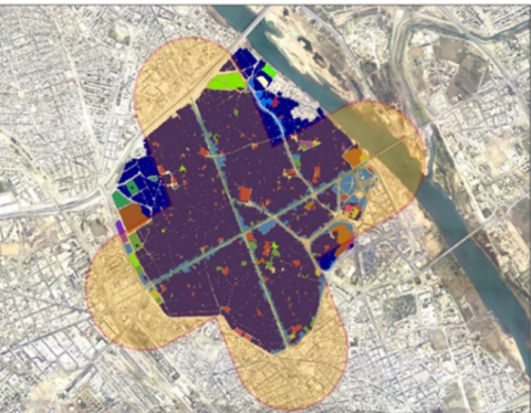
Figure 1. The intersection density for historic city and surrounding transition area for 400 m
6.2 Index of accessibility to transit paths X5
Through this indicator, transit paths that contain transportation nodes required to transport people to their destinations are measured. According to international indicators, the location of any functional entrance to any building in the area is determined within a walking distance of 400 meters from the current or planned bus, tram, or unofficial transportation stations. The purpose of this indicator is to provide public transport services and reach them based on the effectiveness of walking to reduce dependence on the use of personal vehicles.
This indicator was measured in two ways: the first by means of space syntax theory and its program UCL 10, and the second by the GIS system and ArcMap 10.8 program.
6.2.1 Spatial structure analyses
The theory of spatial structure was employed to measure the standard of accessibility to the transit paths, to identify the potentials of the historic city's urban fabric, and to measure the extent to which the historic city is integrated with the rest of the urban fabric of the city. This theory is based on the analysis and description of the social and behavioral characteristics of the various types of human communities that produced the spatial urban systems, attempting to make them abstract and express them mathematically using an analytical and topological analysis by means of studying the relations between the elements that constitute the spatial structure systems. This theory rests on two basic features in the process of analyzing those systems, which are symmetry – asymmetry, distribution, and non-distribution [34] that were measured using local scales and which are represented by the space and its adjacencies connected to it directly through the characteristics of connectivity and the position control in addition to comprehensive scales that determine the nature of the relationship with the rest of the spatial system via the integration characteristic as the latter represents the relative symmetry within the spatial system and it is measured from the inverse result of the relative asymmetry of the system [34].
* The highest value of integration was (2.1) in the path of the third bridge—Festivals Minassah.
* The average value of the integration was 1.35, but the lowest value on the level of the city was 0.45.
* The average value of the integration was (1.89) for the path of Historic Bridge Street—Ras AlJaddah.
* The average value of the integration was (1.8) for the path of AlFarooq Street-Bab AlJadeed, as shown in Figure 2.
* The highest value of integration was (4.6), while the average value was (2.4), and the lowest value on the level of the historic area was (1).
* The average value of the path of AlFarooq Street—Bab AJadeed was (4.02) path code 1.
* The average value of the path of the historic bridge, Ras Al-Jaddah, was (3.99) path code 2.
* Also, results showed that there are movement axes in the historic fabric that have relatively high integration values, as shown in Table 4. and Figure 3. It can be used in active mobility (cycling) because it has a width that allows the use of these media within the fabric; the width of these axes exceeds 3 m. The width of the track designated for bicycles must not be less than 1.5 m in all cases, taking into account the specificity of the historic fabrics. Which can be used as cycling and walking paths at the same time.
Figure 2. The intersection density for historic city and surrounding transition area for 400 m
Table 4. Integration values of the axes inside the historic city
|
Path Code |
Integration Average Value |
Path Code |
Integration Average Value |
|
3 |
2.28 |
8 |
2.6 |
|
4 |
2.2 |
9 |
2.57 |
|
5 |
2.15 |
10 |
2.55 |
|
6 |
2.54 |
11 |
2.69 |
|
7 |
2.67 |
12 |
2.32 |
* The highest value of the connectivity characteristic was 4234, while the value of the connectivity characteristic was 204. On the other hand, the lowest value of the connectivity characteristic was for the historic area (1).
* The average value of the connectivity characteristic of the AlFarooq Street-Bab AlJadded path was 2065.
* The average value of the connectivity characteristic of the historic bridge-Ras Al-Jaddah path was (1169).
The results of the connectivity characteristic showed that there are axes that possess relatively high connectivity values in the historic city's urban fabric. In addition to other axes whose width exceeds 3 m and have high positional control values, which can be used as paths for bicycles and walking at the same time, as shown in Table 5 and Figure 4.
Table 5. Integration values of the axes inside the historic city
|
Path Code |
Average Connectivity Value |
Path Code |
Average Connectivity Value |
|
3 |
120 |
8 |
122 |
|
4 |
98 |
9 |
180 |
|
5 |
78 |
10 |
164 |
|
6 |
228 |
11 |
130 |
|
7 |
209 |
12 |
127 |
6.2.2 GIS analysis
An analysis was conducted according to the GIS system of the main movement axes of the historic city, and the result was according to the analysis of the main axes of the historic city. The area of non-coverage according to the criterion of 400 m is 40.8 hectares, out of the area of the historic city of 240 hectares. The non-coverage rate reached 17.05% of the area of the historic city, as shown in Figure 5.
The presence of high internal correlation index values for the historic city, amounting to 226% of the global index, with high internal correlation values for the neighboring regions, which amount to 188% of the global index, makes the historic fabric a supportive fabric for walking environments, with high index values for the transit axes of public transport, which have high values of integration, connectivity and local control for the axes of Al-Farouk Street - Bab Al-Jadeed and the path of Ras Al-Jisr - Ras Al-Jada, in addition to the possession of these axes for a coverage rate of public transport service of up to 83%. According to the analysis of the GIS system, which makes these axes supportive of public transport in a large way for the historic fabric, according to the index of internal connectivity and permeability of the historic fabric and its neighborhoods, in addition to the indicator of transit axes, the historic fabric is considered a supportive fabric for the work of sustainable transport systems within it (active mobility and public transport) according to global indicators for sustainable transport.
Figure 6. Erosion of the historic urban fabric due to overuse of personal vehicles
The researchers would like to thank the University of Mosul - College of Engineering - Department of Architecture for facilitating the process of completing this research.
[1] Shehata, A.M. (2022). Current trends in urban heritage conservation: Medieval historic Arab city centers. Sustainability, 14(2): 607. https://doi.org/10.3390/su14020607
[2] Newman, P., Thomson, G., Helminen, V., Kosonen, L., Terämä, E. (2019). Sustainable cities: How urban fabric theory helps sustainable development. Reports of the Finnish Environment Institute, pp. 13-15. https://helda.helsinki.fi/server/api/core/bitstreams/0cd8dea8-0e19-490c-a189-936168c8148f/content.
[3] Sharifi, A., Murayama, A. (2013). Changes in the traditional urban form and social sustainability. Habitat International, 38: 126-134. https://doi.org/10.1016/j.habitatint.2012.05.007
[4] Baghaiepoor, M. (2018). Walkability in historic urban fabrics and its role in urban planning and design. ICUP 2018 International on Urban Planning. https://www.researchgate.net/publication/344931129.
[5] Newman, P., Kosonen, L., Kenworthy, J. (2016). Theory of urban fabrics: Planning the walking, transit/public transport and automobile/motor car cities for reduced car dependency. Town Planning Review, 87(4): 429-458. https://doi.org/10.3828/tpr.2016.28
[6] Moha, D., Tiwari, G. (2020). Sustainable Approaches to Urban Transport. CRC Press, Taylor & Francis, Boca Raton.
[7] Dilmi, D. (2014). Traffic problems in the core area of the historic city of Casbah, Algiers: From urban conservation to sustainable development. World Sustainable Building Barcelona, Barcelona, Spain, pp. 65-73. https://www.researchgate.net/publication/330181029.
[8] Ragheb, A., Ragheb, R.A., Ahmed, G. (2012). Toward sustainable urban development of historic cities: A case study of Foha city, Egypt. Ain Shams Engineering Journal, 13(1). https://doi.org/10.1016/j.asej.2021.06.006
[9] Grant, J. (2006). Planning the Good Community: New Urbanism in Theory and Practice. Routledge Taylor and Francis, London.
[10] Bakogiannis, E., Kyriakidis, C., Siti, M., Floropoulou, E. (2019). Reconsidering sustainable mobility patterns in cultural route planning: Andreas Syngrou Avenue, Greece. Heritage, 2(2): 1702-1723. https://doi.org/10.3390/heritage2020104
[11] Brundtland, G.H. (1987). Report of the World Commission on Environment and Development: Our Common Future. United Nations Publication, Oslo.
[12] Chan, N.W., Imura, H., Nakamura, A., Ao, M. (2016). Sustainable urban development textbook. Water Watch Penang C/O School of Humanities, Penang, Malaysia.
[13] Haughton, G., Hunter, C. (2005). Sustanable Cities. Taylor & Francis e-Library Routledge, London, 301.
[14] UNESCO for Asia and the Pacific. (2012). Sustainable Urban Transportation Systems. United Nations Economic and Social Commission for CITYNET, Yokohama.
[15] United Nations. (2021). Sustainable Transport, Sustainable Development: Interagency Report | Second Global Sustainable Transport Conference.
[16] Kent, G. (1982). Meanings of development. Human System Management, 3: 188-194.
[17] Abuiyada, R. (2018). Traditional development theories have to address the needs of the majority of people at grassroots levels with Reference to GAD. International Journal of Social Science, 9: 115-119. https://doi.org/10.30845/ijbss.v9n9p12
[18] Faracik, R. (2014). Witch cities are historic? To define the phenomenon in the context of tourism development context". In Enhancing the Compatibility of v4 Historic to Develop Tourism. DIDAKT Kft., Debrecen Responsible Publisher, Hungary/D.
[19] Daoud, A.S. (1992). Mosul civilization encyclopedia, volume V: Urban and urban planning for the city of Mosul, plans for the city of Mosul since the beginning of the twentieth century. University of Mosul, Dar Al-KUTUB for Printing and Publishing, Mosul, Iraq.
[20] Hamid, A.S. (1992). The civilizational encyclopedia of Mosul, volume V: The structure of the city of Mosul and its current image. University of Mosul, Dar Al-Kutub for Printing and Publishing, Mosul, Iraq.
[21] UN-Habitat. (2016). City profile of Mosul, Iraq: Multi-sector assessment of a city under siege. United Nations Human Settlements Program in Iraq (UN-Habitat), Arbil, pp. 13-16.
[22] Ali, S.A.H., Sherzad, M.F., Alomairi, A.H. (2022). Managing strategies to revitalize urban cultural heritage after wars: The center of the historic city of Mosul as a case study. Buildings, 12(9): 1298. https://doi.org/10.3390/buildings12091298
[23] Soares, I., Yamu, C., Gerd, W. (2020). The relationship between the spatial configuration and the fourth sustainable dimension of creativity in university campuses: The case study of Zernike campus Groningen, The Netherlands. Sustainability, 12(21): 9263. https://doi.org/10.3390/su12219263
[24] European Environment Agency. (2021) Recommendations for green and healthy sustainable transport: Building forward better. Health and Environment Steering Committee Publisher, 2021. https://unece.org/pep/publications/recommendations-green-and-healthy-sustainable-transport-building-forward-better.
[25] US Building Council. (2019). 1 Residential BD+C Multifamily Home v4.1, LEED, West Michigan. https://www.homeinnovation.com/-/media/Files/Certification/Green_Building/NGBSLEEDMULTIFAMILY_41Comparison2020.pdf
[26] US Building Council. (2019). Cities and Communities Existing, LEED, West Michigan. https://www.usgbc.org/leed/rating-systems/leed-for-cities-communities.
[27] US Building Council, LEED for Neighborhood Development, Location and Transportation, U.S. Green Building Council. https://www.usgbc.org/credits/homes-high-rise/v4-draft/ltc1, accessed on Nov. 2, 2022.
[28] BRE Global Ltd. (2016). BREEAM international new technical manual BRE global limited. Watford.
[29] BRE Global Ltd. (2017). BREEAM Communities Technical Manual. BRE Global Limited, Watford.
[30] Green Building Council of Australia. (2017). Green Star: Design and As Built v1.2. Green Building Council of Australia, Sydney.
[31] 20 Years of CIVITAS Sustainable and Smart Mobility for All. (2022). Introducing the CIVITAS Initiative. 2022 CIVITAS Initiative. https://civitas.eu/about, accessed on Feb. 8, 2023.
[32] Acharya, A., Karimi, K., Parham, E., Guven, A., Uyar, G. (2017). City planning using integrated urban modeling: Jeddah structure plan. Proceedings of the 11th Space Syntax Symposium, Instituto Superior Técnico, Lisbon-Portogal, pp. 37.1-37.21. https://doi.org/10.30845/ijbss.v9n9p12
[33] Johnson Victor, D., Ponnuswamy, S. (2012). Urban Transportation Planning, Operation, and Management. Tata McGraw Hill Education Private Limited.
[34] Hiellier, B., Hansson, J. (1984). The Logic of Space. Cambridge University Press, 26-51.