Purwanto | Siti Hamidah | Wulandari Dwi Etika Rini*
© 2022 IIETA. This article is published by IIETA and is licensed under the CC BY 4.0 license (http://creativecommons.org/licenses/by/4.0/).
OPEN ACCESS
Water is a very important natural resource that is needed by all living things in all their life activities. Research related to water and how to use water resources is an important issue. The amount of fresh water available on earth is only about 25% of the total water. The aim of this study is to identify potential aquifers with the geoelectric method. This can be a consideration in determining the right location of the well in relation to efforts to obtain potential groundwater resources to meet the needs of raw water, both in terms of quantity and quality. The method used is a field survey by making observations including rock permeability measurements, infiltration, laboratory and studio work. Field work also includes geoelectric measurements, observations of groundwater levels and land use, and analysis of aquifers to determine the location of drill points that have the potential to be developed. The results show that the supply of raw water for a number of locations spread across Gunungkidul Regency is very much needed, considering that in the dry season there is a shortage of water. Groundwater conditions using the Schlumberger Method show that they have sufficient raw water potential, but in terms of depth and discharge, each location is different from one another. Planning for borehole construction is highly recommended, and planning is adjusted to the amount of demand and availability of raw water.
aquifer, geoelectricity, groundwater, identification
Water is a very important natural resource that is needed by all living things in all their life activities. The amount of fresh water available on earth is only about 25% of the total water. The identification and management of groundwater quality is critical to maintaining freshwater resources in arid and semi-arid areas, it is essential for sustainable development [1].
Most of the water used for daily life for the community comes from shallow/dug well water. This groundwater is widely used by residents for various purposes with a well depth generally between 1-25 meters. Free groundwater is still the main source of clean water for most of the population in meeting their daily needs. Its utilization is carried out by making dug wells and pantek wells at a depth of less than 20 meters below the surface. The free groundwater reserves in 2015 during the winter season in Solo were only 1.34 billion L and the groundwater was constrained at the same time reaching 21 billion L. While the water needs of the residents of Solo were 51 million L / day, so it is estimated that there will be a well water crisis in 2020 [2]. There are many challenges related to the water crisis, this is due to the increasing population, pollution of water resources, errors in managing resources, and imbalances in water use policies [3].
Groundwater as one of the potential raw water resources has received a lot of attention in relation to meeting raw water needs for domestic needs. As an effort to meet the needs of raw water, especially drinking water in an area, the provision of groundwater is always associated with the condition of groundwater that is healthy, cheap and available in the amount as needed. Groundwater is one of the good raw water resources for drinking water.
Groundwater resources are naturally renewable, because groundwater is an integral part of the hydrological cycle on earth. However, in reality there are various limiting factors that affect its utilization, both in terms of quantity and quality. In terms of quantity, groundwater will experience a decrease in the ability to provide if the amount used exceeds its availability. The decline in groundwater quality is caused by industrial and domestic activities which dispose of waste without prior treatment, which has a negative impact on water resources.
The problem of groundwater potential, both quantity and quality, is always related to the characteristics of the geological constituent materials in which the groundwater is located. The assessment of renewable groundwater resources is the basis for calculating groundwater, which is defined as a quantitative assessment of groundwater use [4].
Groundwater is present in several types of geology and geological structures and stratigraphies, and one of the most important is aquifers. Estimation of the hydraulic properties of aquifers is very important in predicting the aquifer's response to extraction so as to estimate the availability of groundwater [5]. It is this aquifer that will affect the availability of groundwater, because groundwater is between the cavities in the rock layer.
If the rock layer can only store but cannot drain the amount of water which means it is called a waterproof layer. If a rock layer cannot store and drain water or is impermeable to water absolutely called aquifuge, while when a stratum can store and flow water slowly from one aquifer to another and pat drain water when applied pressure is called aquitard.
An aquifer is a layer of rock that can store and transmit large amounts of water. This is because the layer is composed of rocks that have high porosity and permeability such as gravel and sand. The types of aquifers include free aquifers, confined aquifers, leaky aquifers, composite aquifers, and hanging aquifers. This classification is based on the location of the water level below the surface, the structure and hydraulic conductivity being confined aquifer and unconfined aquifer. Caracterization of aquifers can be carried out using certain geophysical techniques with re-physic activity listrik, induksi elektromagnetic, ground penetrating radar and teknik seismic [6]. The characterization of aquifers depends on the petro-physical properties of the subsurface. Based on the position of groundwater in the geological formations mentioned above, groundwater is classified as free groundwater, semi-stressed groundwater, and compressed groundwater. An understanding of the lateral area of shallow groundwater aquifers and the depth to the aquifer will minimize the cost and time required for drilling [7].
Based on monitoring conducted by the Regional Environmental Impact Management Agency of the Special Region of Yogyakarta since 2002, it has shown a decline in the quality and quantity of groundwater. Water pollution must be controlled due to its rapid development [8]. The results showed that the groundwater in the area had been polluted with koli, nitrite, ammonia and iron bacteria as well as a decrease in the discharge of deep-drilled wells and an increase in the depth of dug wells.
The development of physical development that occurred in the Special Region of Yogyakarta, resulted in a decrease in the quantity of ground water. One of the regencies in the Special Region of Yogyakarta, which is the catchment area which is spread locally and in a small area, is in Gunungkidul Regency. The characteristic of catchment area in Gunungkidul Regency cause the groundwater system in the area to be different and not as good as groundwater conditions in other areas.
Some groundwater basin areas in Gunungkidul Regency have a specific hydrological system, namely with a small groundwater potential due to rock characteristics that cannot properly store and distribute water. In the rainy season, generally the depth of groundwater in the region is more than 15 m with fluctuations in the depth of groundwater levels ranging from 4-15 meters. In the dry season, most of the groundwater is found in the deep aquifer layer (> 40 meters) and some are in the form of underground river grooves that are difficult to detect, making it difficult for people in the region to use water to meet raw water needs. Therefore, to meet water needs in water-difficult areas, additional facilities for making deep groundwater drill wells and equipment for groundwater production are needed. Research related to water and how to use water resources is an important issue [9].
Based on the description above, it is important to determine the right well location in relation to efforts to obtain potential groundwater resources to meet raw water needs, both in terms of quantity and quality. In other words, to be able to obtain potential groundwater resources, the production wells built must be exactly in the productive aquifer zone. Determination of drilling locations, well depths and studies of aquifer potential conditions in water-difficult areas are very necessary before carrying out groundwater drilling to be successful as expected, so it is necessary to identify aquifer potential as a basis for technical planning as a reference in the implementation of making deep groundwater drilling wells.
2.1 Aquifer
Rainwater that falls on the surface in the hydrological cycle is divided into two parts, first as overland flow and secondly as infiltrated water. The number of parts of water flowing as runoff streams and infiltrating depends on many factors. The larger the part of rainwater that flows as a runoff stream, the smaller the part of the infiltrated water will become, and vice versa. The subsequent runoff flow will fill the depression storage. When this reservoir has been fulfilled, the rest will become a surface runoff in the form of streams and tributaries that emptied into the sea.
Infiltrated water, when the state of geological formations permits, can partly flow laterally in the unsaturated zone as sub surface flow/interflow, others flow in the vertical direction as a percolation that will reach the saturated zone aquifer. The water in this aquifer will flow as a groundwater flow, river flow or in deep storage.
Aquifers are saturated geological formations so that they can be used as suppliers of water in economical quantities (the amount is sufficient for a purpose such as domestic, agriculture, animal husbandry, industry and others). Therefor this formation must be able to store and pass water. As well as a geological unit that is saturated and able to supply water to wells or springs so that it can be used as a source of water. Another term is water bearing formation or also groundwater reservoir. To be able to float as an aquifer, a rock must be porous or hollow that is related to each other, so that it can store and let water move from cavity to cavity. The properties of aquifers depend on the physical characteristics of the material such as porosity, permeability, specific yield, specific storage, and hydraulic conductivity determined by techniques such as resistivity surveys and pumping tests followed by remote sensing and geographic information systems for better information on groundwater systems [10].
This groundwater is widely used by residents for various purposes with a well depth generally between 1-25 meters. Unconfined aquifer is still the main source of clean water for most of the population in meeting daily needs. Unconfined aquifer has a special treatment, as it is the main groundwater catchment, shallow and easily accessible to the population at low cost and provides the possibility of natural and artificial groundwater storage [11]. Confined aquifer is an aquifer in which groundwater is located under an impermeable layer and has a pressure greater than atmospheric pressure. Water that flows in its limiting layer, because the confined aquifer is a water-saturated aquifer bounded by its upper and lower layers. Hydraulic height is not the same as water level [12]. By knowing the hydraulic properties of groundwater using a pump test, it can be shown the potential of groundwater which is characterized by an aquifer unit capable of providing results for household needs [13]. A leaky aquifer can be defined as an aquifer in which groundwater is constrained under a half-impermeable layer so that the aquifer here is located between a free aquifer and a curbed aquifer. Fleakage actors can also be calculated; and in the case of free aquifers, the effective porosity and vertical hydraulic conductivity can also be lowered [14]. Floating aquifer if in the aerosic zone an aquifer is formed which is formed above the impermeable layer. Floating aquifer cannot be used as a groundwater development effort, because it has variations in water surface and large volumes.
2.2 Geoelectricity
Geoelectricity is a geophysical method that studies the nature of the flow of electricity in the earth and how to detect it on the earth's surface. This includes the measurement of potential, current, and electromagnetic fields that occur both naturally and as a result of the injection of currents into the earth. With geoelectrical analysis, zones that have groundwater potential can be identified [15]. Therefore, geoelectric methods have many kinds, including self-potential methods, telluric current, telluric magneto, electromagnetic, polarization induction and resistivity. Geoelectric resistivity is a method used to determine the change in the resistance of the type of rock layer below the earth's surface by flowing direct current electric current [16]. The geoelectric resistivity method is carried out by injecting electric current into the earth through a current electrode then the potential difference is measured through two potential electrodes. If an electric current is injected into a medium and a potential difference is measured, then the resistance value of the medium can be estimated [17]. This method is more effective when used for shallow exploration, since it is very good to know the information of layers at a depth of less than 150 meters. Generally, this method is used in the field of engineering geology, such as: determination of the depth of bedrock, search for Groundwater reservoirs, mineral exploration, and geothermal. Rocks that have high axle resistivity, their conductivity will be smaller, and vice versa if the rocks with low resistivity.
This research uses the field survey method by making observations in the field including:
After taking the field survey data, the next steps are Collection and compilation of regional geological data, geomorphology, hydrogeology, climatology, land allotment in general in the research area. Taking and analyzing geoelectric data in the research area to examine aquifers and potential groundwater points for their development plans. Evaluation and analysis of data that trigger changes in groundwater levels in changes in the hydrological system. Geoelectric analysis to determine the hydrogeological system and the direction of groundwater flow as well as aquifer variations for consideration of regional development planning in the research area. Make recommendations on the development of groundwater and the provision of technical and design documents for its development. Identify the position of the drilled well and the target area.
The purposive research area was determined on the North Slope of the Baturagung Mountains, Gedangsari District, Gunungkidul Regency, with consideration considering that most of these areas are areas that are difficult to meet domestic and non-domestic clean water needs. So that this study contributes to determining the location of the drilling point and compiling a technical plan for the manufacture of production drilling well installations so that certainty of drilling locations is obtained that will produce sufficient water production.
The basin characteristics of Gunungkidul District mean that the groundwater system in this area is different from other areas and the groundwater conditions are not good. Some groundwater bodies in Regency Gunungkidul have special hydrological systems with low groundwater potential due to rock properties that cannot properly store and distribute water. During the rainy season, the groundwater depth in this area usually exceeds 15 m, and the water table depth varies between 4 and 15 m. During the dry season, most of the groundwater resides in deep aquifers (>40 meters), some in the form of underground river gully, which is difficult to detect, so people in this area meet their raw water needs. It becomes difficult to use water for Therefore, additional facilities for generating deep groundwater drilling wells and facilities for groundwater extraction are required to meet the water demand in water-scarce areas.
The need for raw water for various purposes over time has increased quite rapidly. The cheapest provision of raw water for the community is when obtained from airtanah, especially shallow groundwater. However, the availability of insufficient amounts of shallow groundwater is an obstacle in itself when the need increases. Sumber water that can be used to maintain water availability includes springs, rivers, and wells that can be used to meet the domestic needs of residents [18].
Various methods applied to the tracing of groundwater conditions have been widely practiced. One of the models or methods that can be applied to determine the location or investigation of production wells is the geoelectric survey method that can be correlated with the results of analysis of existing drill data. The basic principle of geoelectric estimation is that each layer of rock or constituent material has a different resistanceivity. Based on the difference in resistivity values, it can beused to trace the type of constituent material, the position of the phreatic face and the relative condition of groundwater, the arrangement of rock layers and the types of aquifers that make up them. The results of this analysis can further be correlated with the results of drill data analysis, which provides information about the type, arrangement and thickness of the constituent material, so that the location of the well can be determined.
Research conducted in Gedangsari Subdistrict, Gunungkidul Regency, showed that the lithology that composes the area of tertiary deposits that make up the southern mountains. The naming of lithological units in the study area refers to their physiographic position, that is, it refers to the Stratigraphy of the Southern Mountains.
In the context of hydrogeology, the hydrogeological characteristics in Gunungkidul Regency are influenced by the type of lithology that makes up the aquifer layer. Gunungkidul Regency is generally composed of lithologies in the form of tertiary volcanic rocks, layered limestone, and reef limestone that form karst areas. The existence of groundwater is generally influenced by the porosity of rocks and fracturing in rocks, both caused by dissolution processes and tectonic processes.
The groundwater level in Gunungkidul is relatively deep, this is due to the existing rock structure and texture. Especially in the southern part, where the large layers of cracked karts rocks result in groundwater flowing directly into the lower layers, usually ending up in underground rivers, which are at a depth of approximately 200 meters. In this region rainwater is often caught in lakes, which become a source of surface water in the dry season. This condition makes the availability of clean water, especially in the dry season, often a problem. Water for domestic use often comes from tanks filled with rainwater. In prolonged dry seasons, water often has to be held from outside the county through tank trucks. Water shortages also have implications for the type of farming that is possible.
The hydrogeological conditions of the study area are influenced by lithological conditions which are Tertiary-aged bedrocks that physically have smaller porosity and permeability values. The primary porosity and permeability of rocks in the study area are relatively small, while their porosity and secondary rehabilitation are also relatively small with neither the intensive geological structure nor the dissolving process in these rocks. To find underground resources such as groundwater using soil resistivity through geophysical surveys [19]. Geoelectric is a geophysical method used in this study. In this case, it includes measurements of potentials, currents, and electromagnetic fields that occur, both naturally and due to the injection of current into the earth. On a method of resistivity electric current injected into the earth through a current electrode, then the potential difference that arises is measured through two potential electrodes. From these measurements for different electrode distances can then be derived variations in the value of the type resistance of each layer below the measuring.
This method is more effective when used for shallow exploration, some electrical properties are electrical potentials that utilize the conductivity properties of rocks to detect subsurface states by holding measurements on the earth's surface. Vertical Sounding aims to obtain information about the depth/thickness of rock layers from their resistivity prices vertically, in order to get a complete geological picture below the surface. The difference in resistivity will be clearly seen in determining the depth of rock layers that have different types of resistance.
Figure 1. Illustration of current electrode and geoelectric potential electrode
In the resistivity method, an electric current is injected into the earth through the current electrode (AB), then the potential difference (V) and the current strength (I) that arises is measured through two potential electrodes (MN) (Figure 1). From these measurements for different electrode spacing can then be derived price variations resistivity of each layer below the measuring point.
The observer stations are made fixed, while the current and voltage electrodes are driven according to the addition of the electrode distance. The spacing of the electrode will determine the magnitude of the geometric factor (K) = 2 a$\pi$.
Geoelectric measurements in the field use the Schlumberger method, by means of Vertical Electrical Sounding. The Schlumberger method chosen because this method needs to move the two current electrodes only for most readings. This can significantly decrease the time required to acquire a sounding. The measured price in the field is the price of a pseudo-type resistance, which needs to be analyzed by the method of arch equalization using the standard curve. In this investigation, the data is recorded and measured in the field. Noted No Location, Assimilation, and Geographic Location. Measured: The range of current electrodes, potential electrode range, flowing current, as well as pseudo-type resistance (ohm-m). The tool used in this measurement reads digitally, which can know the course of the injected current, so that it can be known when the current is disturbed. In line with the research in Palu City with the configuration used is the Schlumberger configuration which uses 2 current electrodes and 2 potential electrodes [20].
The lithology or forming rocks of this area are pumice stone and sandstone. Each location has a different lithology.
4.1 Candi Area (CND), Tegal Rejo Village, Gedangsari District, Gunungkidul Regency
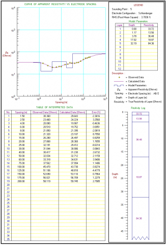
CND1: Constituent rocks in the form of volcanic sandstone, and breccia. There is one aquifer, where the aquifer has a depth of groundwater at 3 - 13 m, an aquifer thickness of 10 m and has a resistivity value of 9.3 ohms-m (Figure 2).
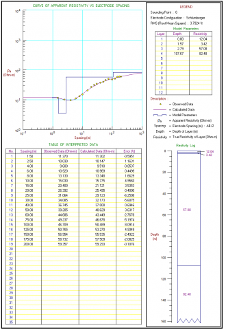
CND2: The constituent rocks are infested with volcanic sandstone, tuff and breccia. There is one aquifer, where the aquifer has a depth of Groundwater at 12 - 80 m, an aquifer thickness of 68 m and has a susceptibility have resistivity of 8.64 - 66.6 ohm-m (Figure 3).
Figure 2. CND1 geoelectric data processing
Figure 3. CND2 geoelectric data processing
CND3: Rock Constituent Form breccia. Do not exist aquifers at this point (Figure 4).
Geoelectric measurement point of Candi area, Tegalrejo Village is shown in Figure 5.
Figure 4. CND3 geoelectric data processing
Figure 5. Geoelectric measurement point of Candi area, Tegalrejo Village
Figure 6. Correlation of Geoelectric Data of Candi Area, Tegalrejo Village (Without Scale)
Based on 3 geoelectric measurement points, it was found that the most potential result for groundwater drilling was CND 2 with an aquifer type resistance value of 8.64 - 66.6 ohm-m. at a depth of 12 – 80 meters. The aquifer is composed of volcanic sandstones and volcanic breccia (Figure 6).
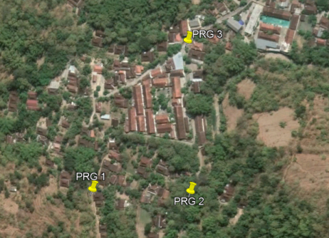
4.2 Prengguk Area (PRG), Tegalrejo Village, Gedangsari District, Gunungkidul Regency
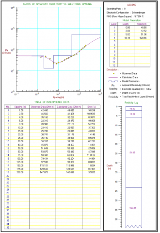
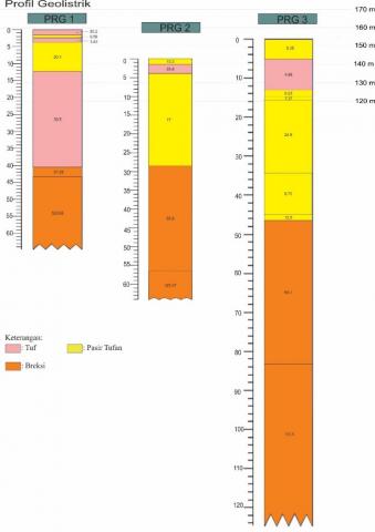
PRG1: Constituent rocks in the form of volcanic sandstone sand breccia. There is one aquifer, where the aquifer has a depth of 3 - 12 m, the aquifer and aquifer are 9 m and have a resistivity value of 20.1 ohm-m (Figure 7).
Figure 7. Prg1 geoelectric data processing
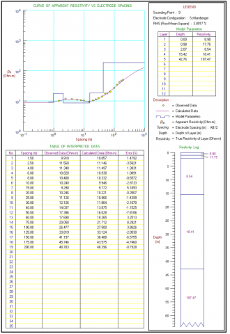
PRG2: Constituent rocks in the form of volcanic sandstone, tuff, and breccia. There is one aquifer, where the aquifer has a groundwater depth of 4 - 29 m, a ferrous aquifer thickness of 25 m and has a resistivity value of 17 ohms-m (Figure 8).
Figure 8. PRG2 geoelectric data processing
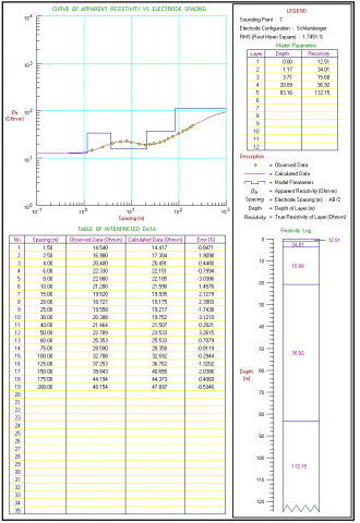
PRG3: Constituent rocks in the form of volcanic sandstones and breccia. There is one aquifer, where the aquifer has a depth of Groundwater at 10 - 80 m, an aquifer thickness of 70 m and has a resistivity susceptibility of 4.86 - 65.1 ohm-m (Figure 9).
Geoelectric measurement point of Prengguk area, Tegalrejo village is shown in Figure 10.
Figure 9. PRG3 geoelectric data processing
Figure 10. Geoelectric measurement point of Prengguk area, Tegalrejo village
Figure 11. Correlation of geoelectric data of Prengguk area, Tegalrejo village (Without Scale)
Based on 3 geoelectric measurement points, it was found that the most potential result for groundwater drilling was PRG3 with an aquifer type resistance value of 4.86 – 65.1 ohm-m at a depth of 10-80 meters. The aquifer is composed by an interspersion of volcanic sandstone with volcanic siltstone (Figure 11).
The recommended location of groundwater drilling is selected 2 locations for each area, where the first location is called more recommended compared to the location called the second. Each of the area is shown in Table 1.
Table 1. Recommendation for groundwater drilling locations for each area
|
Location |
Recommendation 1 |
Recommendation 2 |
|
Candi Area, Tegalrejo Village, Gedangsari District, Gunungkidul Regency |
CND 2 |
CND 3 |
|
Prengguk Area, Tegalrejo Village, Gedangsari District, Gunungkidul Regency |
PRG 3 |
- |
Source: Research data
The geoelectrical method was used to identify potential aquifers in the Candi and Prengguk areas of Tegalrejo Village, Gedangsari District, Gunungkidul Regency, so that it can provide an important reference for determining the exact location of water wells. Researchers conducted field investigations, including measurements of rock permeability, infiltration, laboratory and studio work. Groundwater conditions with the Schlumberger Method show that it has a fairly adequate raw water potential, but in terms of depth and discharge, each location is different from each other.
It was found that the most potential groundwater drilling results in the Temple area were CND 2 with an aquifer resistivity value of 8.64-66.6 ohm meters, and a depth of 12-80 meters. The most potential groundwater drilling results in the Prengguk area are PRG3 with an aquifer resistivity value of 4.86-65.1 ohm meters, and a depth of 10-80 meters.
In general, the research area has sufficient raw water potential, but in terms of depth and discharge each location is different. The provision of raw water for a number of locations spread across Gunungkidul Regency is very much needed, considering that in the dry season there is a shortage of water. Planning for the manufacture of drilled wells is highly recommended, and planning is adjusted to the amount of needs and availability of raw water.
The research is supported by Universitas Pembangunan Nasional Veteran Yogyakarta. Department of Public Works, Housing and Energy and Mineral Resources of Daerah Istimewa Yogyakarta Province and CV. Sakalike for data source support. Central Statistics Agency for Gunungkidul Regency for secondary data source support.
[1] Asadi, E., Isazadeh, M., Samadianfard, S., Ramli, M.F., Mosavi, A., Nabipour, N., Shamshirband, S., Hajnal, E., Chau, K.W. (2020). Groundwater quality assessment for sustainable drinking and irrigation. Sustain., 12(1) 177. https://doi.org/10.3390/su12010177
[2] Koesuma, S., Asrib, M.L., Wijayanti, P. (2021). Analysis of free groundwater vulnerability level to pollution using ‘DRASTIC METHOD’ development in Surakarta city. Journal of Physics: Conference Series, 1825(1). https://doi.org/10.1088/1742-6596/1825/1/012009
[3] Rajarethinam, K., Devadas, V. (2021). Water resilience in the Indian context: definitions, policies, approaches and gaps. Int. J. Sustain. Dev. Plan., 16(7): 1263-1273. https://doi.org/10.18280/ijsdp.160707
[4] Krogulec, E., Zabłocki, S., Sawicka, K. (2020). Temporal and spatial diversity of renewable groundwater resources in the river Valley. Appl. Sci., 10(14): 4827. https://doi.org/10.3390/app10144827
[5] Shapoori, V., Peterson, T.J., Western, A.W., Costelloe, J.F. (2015). Estimating aquifer properties using groundwater hydrograph modelling. Hydrol. Process., 29(26): 5424-5437. https://doi.org/10.1002/hyp.10583
[6] Salako Adebayo, O., Adepelumi Abraham, A. (2018). Aquifer, classification and characterization. Aquifers - Matrix and Fluids. https://doi.org/10.5772/intechopen.72692
[7] Wahab, S., Saibi, H., Mizunaga, H. (2021). Groundwater aquifer detection using the electrical resistivity method at Ito Campus, Kyushu University (Fukuoka, Japan). Geosci. Lett., 8(1): 15. https://doi.org/10.1186/s40562-021-00188-6
[8] Sabiq, A., Budisejati, P.N. (2017). Web monitoring system of pH Level, temperature and color on river water using wireless sensor network. J. Teknol. dan Sist. Komput., 5(3). https://doi.org/10.14710/jtsiskom.5.3.2017.94-100
[9] Khudair, M.Y., Kamel, A.H., Sulaiman, S.O., Al Ansari, N. (2022). Groundwater quality and sustainability evaluation for irrigation purposes: A case study in an Arid Region, Iraq. Int. J. Sustain. Dev. Plan., 17(2): 413-419. https://doi.org/10.18280/ijsdp.170206
[10] Akhtar, N., Izzuddin Syakir, M., Talha Anees, M., Qadir, A., Shaiful Yusuff, M. (2021). Characteristics and assessment of groundwater. Groundwater Management and Resources. https://doi.org/10.5772/intechopen.93800
[11] Şen, Z. (2015). Unconfined aquifers. Practical and Applied Hydrogeology. https://doi.org/10.1016/b978-0-12-800075-5.00004-2
[12] Bouts, P.A. (2019). Principles of groundwater flow. Groundwater and Surface Water Pollution. https://doi.org/10.1201/9780203719770-1
[13] Falowo, O.O., Ojo, O.O., Daramola, A.S. (2020). Groundwater resource assessment by hydraulic properties determination for sustainable planning and development in central part of Ondo State, Nigeria. Environ. Earth Sci. Res. J., 7(1): 1-8. https://doi.org/10.18280/eesrj.070101
[14] Sethi, R., Di Molfetta, A. (2019). Aquifer characterization. Springer Tracts in Civil Engineering. https://doi.org/10.1007/978-3-030-20516-4_4
[15] Ajayi, T., Awotuyi, B., Bello, R. (2019). Geoelectric assessment of groundwater potential in Supare Akoko, Southwestern, Nigeria. Environ. Earth Sci. Res. J., 6(2): 59-70. https://doi.org/10.18280/eesrj.060202
[16] Faris, A.N., Suaidi, D.A., Hasan, M.F.R., Broto, A.B. (2019). Identifiction of aquifers distribution using geoelectric-resistivity method with schlumberger configuration in Gedangan village, Malang Regency. Nat. B, 5(1). https://natural-b.ub.ac.id/index.php/natural-b/article/view/457.
[17] Usman, B., Manrulu, R.H., Nurfalaq, A., Rohayu, E. (2017). Identification of groundwater aquifers in palopo city using the schlumberger configuration resistance geoelectrical method. J. Fis. FLUX, 14(2). https://doi.org/10.20527/flux.v4i2.4091
[18] Yogafanny, E., Anastasia, T.T., Utama, V.F. (2020). Zonation of ground water vulnerability using COP and APLIS methods in Gremeng Watershed, Umbulrejo village, Ponjong, Gunungkidul. JPPDAS, 4(2). https://doi.org/10.20886/jppdas.2020.4.2.103-120
[19] Hakaew, P., Panmuang, P., Prabpal, P., Photong, C. (2022). An application of multi-frequency alternating current source for VES on soil resistivity measurement and investigation. Instrum. Mes. Metrol., 21(2): 79-85. https://doi.org/10.18280/i2m.210206
[20] Riskawati, R., Abdullah, A. (2021). Identification of the aquifer layer by geoelectric method in Poboya Sub-district Palu City. Gravitasi, 20(2). https://doi.org/10.22487/gravitasi.v20i2.15737