Mario Rainaldi![]()
© 2023 IIETA. This article is published by IIETA and is licensed under the CC BY 4.0 license (http://creativecommons.org/licenses/by/4.0/).
OPEN ACCESS
The escalating impacts of anthropogenic activities and natural disasters, aggravated by economic crises, have amplified the vulnerability of environmental and territorial systems, leading to significant urban planning and social implications. Consequently, numerous public and private buildings have been abandoned, necessitating crucial reorganizations or repurposing to prevent degradation and obsolescence due to disuse. The imperative goal is to foster resilience within territories, primarily by enhancing the adaptability of urban assets to altered conditions induced by both natural and anthropogenic disturbances, thereby increasing their inherent flexibility to offer functional responses to disruptions. This approach aims to mitigate adverse effects, expedite restoration of the status quo or augment the adaptability of structures, particularly public and strategic ones, during extraordinary phases. The proposed methodology for fortifying solidity and fostering resistance to change in the built environment involves digital cataloguing of heritage through the creation of three-dimensional models of structures. This process, known as Building Information Modelling (BIM), is predicated on a preliminary analysis of structural, architectural, and plant engineering data, which is beneficial for both ordinary and atypical management. The result is an efficient system that offers facility management opportunities for structures throughout their lifecycle and facilitates optimization of resource use. It aids in evaluating the extraordinary use of assets, examining various performance hypotheses for each scenario, understanding the time required for system setup, and determining relative economic indicators until the restoration of the preceding state.
risk, management, tool, plan, public assets, Building Information Modelling (BIM)
This paper aims to explore the significant role that the growing digital transition plays in facilitating the development of comprehensive asset management strategies. Its main objective is to establish a systematic approach for optimizing the value of public assets within their specific environment, in order to generate significant benefits for the broader community. The focus extends beyond economic considerations, encompassing both the containment of energy consumption (management, maintenance costs) as well as the social implications involved [1].
The systematic implementation of public heritage redevelopment processes is envisaged as a dual opportunity: enhancing the economic viability of properties and facilitating the reorganisation of urban and environmental systems [2]. Urban environments are the source of 75% of natural resource consumption, 50% of waste generation, and 70% of greenhouse gas emissions [3]. This necessitates the development of sustainable public real estate management strategies, rooted in circular economy principles. Such strategies, initiated by public policies [4], entail the implementation of a production and consumption model that maximises the lifecycle of existing products through sharing, lending, reusing, repairing, reconditioning, and recycling.
The built environment frequently encounters challenges in adapting to changing usability demands and associated internal environmental conditions. This lack of adaptability that is often encountered can render the 'building system' obsolete, thereby diminishing its lifespan. The resilience of an urban environment can therefore be significantly enhanced by increasing the flexibility of a space, i.e., the ability of a system to be conveniently modified in response to contextual changes. This can have beneficial effects on the management and operational efficiency of buildings, reduce obsolescence, guarantee their function, and augment the longevity of the system [5]. Simultaneously, a thorough understanding of real estate assets is pivotal for optimising activities and promoting efficiency, particularly in terms of economic interests [6].
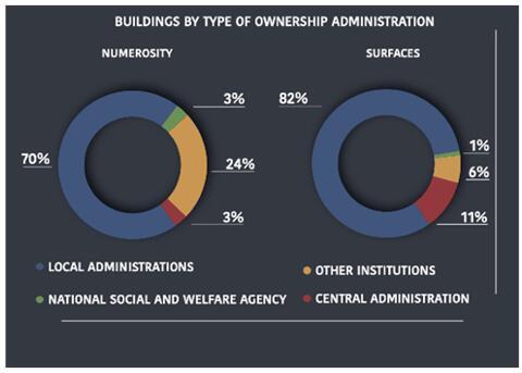
The annual report on real estate properties of Public Administrations in Italy, data 2018, as prepared by the Department of the Treasury of the Ministry of Economy and Finance (MEF), reveals that the total number of declared real estate is approximately 2.76 million, consisting of 1,150,512 buildings and 1,441,246 plots of land [7]. The majority of the properties surveyed belong to local administrations, with municipalities owning about 65% in terms of numbers and 59% in terms of surface area. The central administrations own about 3% in terms of numbers and 11% in terms of surface area, while public social security and welfare institutions own approximately 3% in terms of numbers and 1% in terms of surface area (Figure 1).
Figure 1. Representation of buildings by type of ownership administration (Author’s elaboration, data 2018 report of the Italian Ministry of Economy and Finance)
This data underscores the fact that municipalities, companies, territorial housing corporations, and national public social security and welfare institutions possess substantial real estate assets numerically, predominantly comprising of assets having small surface areas such as dwellings and their appurtenances. Conversely, the state, the regions, the provinces, and the local authorities of the health service own a smaller number, but the assets are larger in terms of surface area. These include historic buildings, offices, prisons, hospitals, etc.
Upon further analysis, the survey categorized assets into 'residential and commercial' (72%) - including dwellings, cellars, garages, commercial premises-and 'institutional purposes' (21%) - such as structured offices, barracks, sports facilities, schools, etc. The remaining 7% were declared as unused. The combined value of the real estate assets of state and local authorities is estimated at EUR 296 billion, with EUR 12 billion of this real estate being disused and solely representing management costs, rather than being adequately valorised.
The survey also indicates a lack of comprehensive knowledge about public assets in Italy. Efforts have been made to enhance the data collection process, expand the database, and improve the quality of the collected information. Collaborations with the Agenzia delle Entrate, through interoperability with the land registry archives, have provided an important cognitive tool allowing for verification of the quality of the communicated data, updating of archives, and implementation of appropriate updating initiatives in cases where a property is not correctly represented in the land registry.
Of the 1,150,512 surveyed real estate units (equating to approximately 377 million square metres), official cadastre matching shows that 85% of units are declared as registered under the ordinary system (roughly 312 million square metres).
The Italian Minister of Ecological Transition, through decree number 304 of 4 August 2022, regulated the operation of the National Portal on the Energy Performance of Buildings, established at the National Agency for New Technologies, Energy and Sustainable Economic Development (ENEA). A data acquisition campaign has been initiated to deepen understanding of the national building stock and its energy performance. Each building will have an identity card detailing all energy performance information to facilitate the evaluation of redevelopment interventions. This system will assist in the analysis of regulatory compliance in the sector and in the verification of any tax benefits, thus reducing the time for the efficiency improvement of the units through this sort of energy mapping of buildings, which reveals potential for improvement and suggests priorities for intervention.
This information will be integrated into an existing database, which includes the regional land registers, the national land register of energy performance certificates (APE), the school building database, the public property agency’s Hyper database, the cadastral archives managed by the Inland Revenue Agency and ENEA, and others. This ambitious project, aimed at the implementation of the measures envisaged by the National Recovery and Resilience Plan (PNRR), will simplify and accelerate procedures for the implementation of energy efficiency measures. However, it is crucial to conduct surveys in a less sectorial and more globalized manner to avoid multiple reconnaissance of the heritage implemented throughout Italy, each with different surveying methods.
In recent years, addressing the process of digitization has become a notable challenge due to the rapid advancements and technological shifts that are taking place on a large scale. Given the circumstances, thoughtful consideration is required regarding the measures to be implemented in order to promote sustainable digital progress and address the forthcoming innovative challenges. A case in point here is progressive digitisation of the built heritage. The International Organisation for Economic Co-operation and Development has highlighted the need to ensure that everyone has the appropriate knowledge for a progressively more digital and globalised future, which is essential for shaping an inclusive and innovative labour market [8].
In addition, for many years now, social awareness of the increased fragility of the environmental system with respect to anthropogenic impacts has been acquired and consolidated [9], which would suggest an interdisciplinary strategy between the programming, planning and management tools of social, land and environmental systems [10].
Thus, increasing urban resilience is now being understood as “the capacity of an urban system and all the socio-ecological and socio-technical networks that comprise it on temporal and spatial scales to maintain or rapidly return to desired functions in the face of a disturbance, to adapt to change and to rapidly transform systems that limit current or future adaptive capacity” [11]. It is necessary to have an adaptive planning approach where uncertainty is at the core, as it involves every stage of the planning process, through methods that include the following steps: assessment of existing conditions, articulation of goals and objectives for consideration of alternatives, decision-making, and development of a plan [12].
The above studies clearly show that it is necessary to standardise and use a single building data acquisition method that is as complete as possible so that it can be used for different purposes, capturing all building information: type, geography, intended use, period of construction, construction materials, installations, flexibility, so as to also implement a timely reading. As in most cases, the data of individual elements are managed within spreadsheets, project reports or in plans (paper or digital) without an organised information management system [13]. Research on 3D modelling of the urban environment has mostly focused on the representation of geometric models but has generally neglected other topological and semantic aspects [14]. Recently, many researchers have focused on the development of 3D semantic building model, acting increasingly in certain applications such as urban planning, land-use management and flow studies [15]. The methodology of inventorying buildings through Computer-Aided Design becomes anachronistic today and the use of BIM methodology becomes predominant [6].
Therefore, it is fitting to incorporate this dynamic, practical approach into a comprehensive system that encompasses all the necessary information related to specific component of a building, infrastructure or any other relevant entity. Such a database can serve as a valuable resource that allows both the coordination during minor or major interventions as well support decision making processes. This technology can be especially beneficial in planning maintenance activities and overseeing technological and environmental management.
The acquisition and sharing of structured data play a crucial role in maximizing and improving the smart governance and economy of the city. This is achieved through technologically advanced 3-D and interactive models of the built environment, which are particularly useful for scenario analysis. To regenerate an area, it is necessary to define criteria to implement the flexibility, adaptability and changeability of an urban system. This can be done through a property census and three-dimensional modelling of buildings, facilities, maintenance, space management, safety, equipment, building geometry, height and construction material. By defining a methodology on which to base the realisation of a three-dimensional urban system, it is possible to initiate a regeneration process through facility management. BIM, in fact, provides opportunities for element management by automatically making a considerable amount of data available. These data give an account of the building stock and its peculiarities, the number of users of a given building, the cognitive layers on land use, morphology and geology. BIM thus becomes an indispensable control and coordination system in Figure 2.
Figure 2. representation of a BIM model example, author’s elaboration
The initial challenge that one must confront is the process of accessing archived documents, which are predominately paper-based. Another obstacle to overcome is the digitisation of the site plans surveys. In the case of an existing building, information and data retrieval are considered as realistic constraints since it would require a system capable of acquiring and making the information easily available [16].
In order to maintain consistency and ensure a uniform level of detail and development, it is essential to standardize data collection methods and the construction of the digital model. This will prevent discrepancies and enable us to precisely define the level of depth for different types of retrieved information, which is commonly referred to as Level of Detail (LOD). It is important to recognize the significance of uncovering gaps and issues related to heritage buildings during this process. The goal is to modernize and enhance such assets by suggesting ways to reduce consumption and improve energy efficiency. In order to ensure the renewal and reorganisation of the school property stock throughout the country, the Italian State, through Article 53 (Decree Law no. 5 of 2012) has set itself to modernise, rationalise, and renovate existing heritage buildings, and the construction and/or completion of new buildings. It intends to do this by applying tools capable of among others, to assess and explore historical and cultural assets, and to provide funds through the promotion of innovative financial instruments (articulated in an integrated national and local system), that are able to support both public and private real estate.
The BIM model can be instrumental in achieving the above-mentioned objectives. Its methodology allows the understanding of spatial and occupant management, enables efficient monitoring and reporting for maintenance purposes, and thus ensuring optimal planned management.
Maintainability and flexibility are two fundamental aspects of sustainable building design. In particular, flexibility is important to adapt to the changing needs of users and the environmental context. Two fundamental aspects must be taken into account: spaces must be designed in such a way that they can be easily changed without structural modifications and the envelope must be able to adapt to different types of use. The lack of these aspects can make a building obsolete and reduce its useful life, which is why it is important to design buildings that can adapt to future needs. The reorganisation of space in rapidly changing contexts is made timely through the use of modular furniture and prefabricated partition walls assembled on site with dry joints, this allows for an effective rearrangement of the environment. Assessing the accessibility is another indispensable element here since multiple accesses certainly guarantee greater building security, an obstacle-free pathway during emergency situations, and further room subdivision. In the case of repurposing of a building, it is crucial to reprogramme the energy and air conditioning systems and potentially modify, minimise or substitute components of it without necessitating a complete system overhaul [17]. These points need to be assessed on the basis of detailed site surveys. In order to potentially adapt and expand the buildings’ volume, it is essential to provide data on both the material and type of façade used. This information becomes crucial as it enables a thorough analysis and facilitates future modifications. An example can be given in the case of a non-load-bearing curtain wall, whereby the closing elements can be removed and replaced with a substitute. Detecting the structure of the building, in addition to defining the level of safety from the seismic point of view of the building, would also allow one to understand the regularity of its spatial layout and type of the protective mesh, and to see if it can be morphologically integrated and grafted with other types of system. In conclusion, possessing knowledge about the availability of domotic systems and digital equipment enables individuals to make informed decisions about whether or not to utilize a particular space.
Home automation is understood as improving the habitability and functionality of rooms, thanks to a set of home automations and technologies.
For example, when changing the use of a room, it is important to check whether a security system is already in place.
In particular, knowing that a room has video surveillance can help to:
*Ensure the security of the material. Video surveillance can help prevent theft, damage or other crimes.
*Collect evidence in the event of an incident. Images recorded by cameras can be used as evidence in the event of an accident or crime.
*Monitor activities in an environment. Video surveillance can be used to monitor activities in an environment, for example to ensure compliance with safety regulations.
If this is the case, it is necessary to consider the new functions that need to be included to ensure the security of the environment in the new use.
Furthermore, the existing security system may not be able to handle the new functionality required by the new use. For example, an environment that changes from a warehouse to a shop may require a security system capable of detecting the theft of goods.
Therefore, it is important to carefully evaluate the new functions that need to be included in the security system when changing use. This will ensure the security of the environment in the new use and avoid potential risks.
The significant distinction arises from the utilization of BIM technology, which is generally used by some as a mere tool for generating digital representations of buildings. This paper proposes its use for ERP (enterprise resource planning) system that plays a critical role in mapping out organization and process workflows. In this case ERP would include support for scheduling and monitoring of maintenance and control check activities of technical networks, heating and electricity plants, cleaning, overhaul, risk assessments and scheduled maintenance policy of assets through cyclic forecasts, etc [18].
The transformative power of advanced Building Information Modelling (BIM) integration has begun to influence the private real estate sector significantly. In fact, it has become so integral to the industry that business entities capitalising on this digitalisation, supported by robust business and communication models, have emerged [19]. These entities have managed to elevate the market value of previously underperforming assets, thereby reducing the seller's marketing investments. An illustrative case is provided by an innovative Italian company's successful sale of a 15th-century Venetian palace. This unique asset, valued at 30 million euros [20], had been visited by numerous international investors over a two-year period without eliciting any expressions of interest. However, the company's creation of a comprehensive 3D documentary database, integrated with maintenance cost data and potential investment figures, facilitated the asset's sale. By translating technical and economic data into a model featuring various business scenarios, the company was able to align efficiency, innovation, and profitability [21].
This BIM-centric approach may be effectively applied to public asset management. As identified in the preceding critical analysis, public assets represent a substantial, albeit poorly managed, wealth. The management costs associated with these assets are two to three times higher than those of private assets. However, with the proper valuation and management strategies, these public assets have the potential to generate considerable economic and social benefits.
To harness these benefits, it is crucial to develop a comprehensive understanding of the asset, including its current state, potential uses, and cost implications. This understanding can be significantly enhanced through the integration of BIM technologies, which enable the detailed mapping of assets and provide valuable insights for strategic decision-making. Furthermore, BIM, as illustrated in the Venetian palace example, can provide a platform for presenting these assets to potential investors, thus increasing their attractiveness and marketability.
The integration of BIM in public asset management could be a game-changer, not only in terms of economic benefits but also in terms of social impact. Well-managed public assets can contribute to the community by providing public goods and services, generating employment, and fostering local economic development. Therefore, the potential benefits of BIM integration extend beyond financial gains, contributing to the broader socio-economic wellbeing.
In conclusion, the reflections made by this study suggest that the integration of BIM technology in both private and public real estate sectors holds great promise. Leveraging BIM's capabilities could lead to improved asset management, increased asset value, and potentially significant economic and social benefits. However, further research is needed to fully understand the long-term implications and potential challenges of this approach.
This article presents a clear call for the integration of a unified information system to supersede current systems. Such a progression, facilitated through intelligent digitalisation of the environment, is brought to the fore by the innovative methodology of the Building Information Model (BIM). Given the vast volume of data, a digital model can be produced that provides an accurate, rapid, and precise reflection of reality. This model, enriched with metric, georeferenced, and implementable information, serves as a prerequisite for the evolution and transformation of assets, which otherwise may become obsolete, thereby reducing their operational lifespan.
Contemporary challenges – economic, natural, and social disturbances – necessitate the reinforcement of territorial resilience through the flexibility and adaptability of public assets. Illustrative of this is a virtuous project undertaken in Turin, which addressed a social emergency by providing residences for those in housing vulnerability [22]. The repurposing of a degraded city building resolved this issue. However, the transformational process, initiated in 2008, was lengthy, with the work only commencing in September 2011 [22]. It is suggested that such delays could be mitigated through increased awareness and understanding of the heritage, facilitated by the integrated digitisation process. Even simple tasks, such as the identification of adduction points (water and gas), can be expedited through a 3-D model, thereby assisting potential changes arising from environmental disturbances.
The lack of heritage awareness is further demonstrated by the numerous public tenders calling for private individuals to conduct energy performance analyses. These analyses often require an examination of both hidden and visible structures, shading, orientation, and extrinsic characteristics, heat generation systems, distribution networks, and proposals for energy performance improvements [23]. In addition, there is a call for an examination of the return on investment. This task is complicated by the concurrent launch of other tenders related to topographical surveys and network controls for the adaptation of safety barriers and lighting systems.
The strategy proposed herein aims to simplify these processes by conducting redevelopment and digitisation simultaneously. It is posited that the detrimental effects stemming from a lack of knowledge of the buildings and their thermo-hygrometric functioning often result in excessive interventions. A more considered approach would be to "do only what is necessary, where necessary," as opposed to adapting to standard parameters suitable for new constructions. Therefore, understanding the current state of the asset is crucial, underlining the importance of accurate diagnosis [23].
In conclusion, a digital system for control and coordination is imperative, serving a dual purpose of maintaining asset efficiency and safety. Such a system can be interwoven with risk forecasting, prevention actions, and the processes governing the territory, thereby significantly reducing wasted funds and decision-making time in an environment disrupted by social, natural, or economic changes [24]. This study, therefore, emphasizes the pivotal role of BIM and integrated digitisation in both asset value enhancement and effective public asset management. However, it also underscores the necessity for further research to fully understand the implications and potential challenges of this approach.
[1] Gabardi, M.T., Bello, E.M. (2021). Gli usi temporanei del patrimonio pubblico abitativo: Alcune sperimentazioni a Milano e Torino. 44-55. https://www.francoangeli.it/rivista/getArticoloFree/70769/It.
[2] Pollo, R. (2012). Increasing the value of the public building assets: The former military sites redevelopment. Journal of Technology for Architecture and Environment, 3(1): 216-223. https://doi.org/10.13128/Techne-10846
[3] Gastaldi, F., Camerin, F. (2015). La rigenerazione urbana ei processi di dismissione del patrimonio immobiliare pubblico e militare in Italia = Urban regeneration and processes of dismissal of public/military real estate in Italy. Institutional Research Information System, 14: 45-58. https://doi.org/10.6092/2281-4574/3014
[4] Balletto, G., Ladu, M. (2022). Il patrimonio pubblico nella transizione ecologica. Urbanistica Informazioni, 50(306): 831-834.
[5] Cellucci, C., Sivo, D.M. (2016). Habitat Contemporaneo. Flessibilità Tecnologica e Spaziale. FrancoAngeli, Italy.
[6] Osello, A. (2015). Building Information Modelling - Geographic Information System - Augmented Reality per il Facility Management. Dario Flaccovio Editore, Caltanissetta, Italy.
[7] A cura della Direzione VII Valorizzazione del patrimonio pubblico. (2018). Patrimonio della PA Rapporto annuale Rapporto sui beni immobili delle Amministrazioni Pubbliche. https://www.dt.mef.gov.it/export/sites/sitodt/modules/documenti_it/patrimonio_pubblico/patrimonio_pa/RapportoImmobili_DatiAnno2018.pdf.
[8] Monti, L. (2019). La digitalizzazione e il futuro passano dalle pubbliche amministrazioni: Il caso della Sardegna. Amministrazione in Cammino. https://storage.googleapis.com/jb-wp-uploads/ammincammino-web/2019/10/Monti-Digitilazzazione-e-futuro-Copia-in-conflitto-di-Michela-Tresca-2019-10-07.pdf.
[9] Stanganelli, M. (2003). La vulnerabilità territoriale ai rischi naturali, Italy, pp.1-18.
[10] Manzo, A.R. (2004). Strumenti e metodi del “governo del territorio” applicati al tema della pianificazione delle aree a rischio di incidente rilevante, nell'attuazione del DM 9 maggio 2001. In Conference Proceedings Risk Assessment and Management in Civil and Industrial Settlements.
[11] Meerow, S., Newell, J.P., Stults, M. (2016). Defining urban resilience: A review. Landscape and Urban Planning, 147: 38-49.
[12] Kato, S., Ahern, J. (2008). ‘Learning by doing’: Adaptive planning as a strategy to address uncertainty in planning. Journal of Environmental Planning and Management, 51(4): 543-559.
[13] Osello, A. (2015). Building information modelling, gegraphic information system, Augmented Reality per il Facility Management. pp. 1-300.
[14] Brenner, C., Haala, N. (1998). Fast production of virtual reality city models. International Archives of Photogrammetry and Remote Sensing, 32(4): 77-84.
[15] Benner, J., Geiger, A., Leinemann, K. (2005). Flexible generation of semantic 3D building models. In Proceedings of the 1st International, Workshop on Next Generation 3D City Models, Bonn, pp. 17-22.
[16] Del Giudice, M. (2015). L’impostazione di un modello BIM per un edificio esistente. In Building information modelling. Geographic information system. Augmented reality per il facility management, pp. 40-49. Dario Flaccovio Editore srl.
[17] Sivo, D.M. (1992). Il progetto di manutenzione. CINECA Institutional Research Information System, 3: 1-231.
[18] Sivo, D.M., Ladiana, D. (2019). LE MURA URBANE CROLLANO. Conservazione e manutenzione programmata della cinta muraria dei centri storici. Institutional Research Information System, 3: 9-217
[19] Stefano Baroncini. (2022). Strategic management of public assets for sustainable habitat: planning, management and control tools. Università degli studi G.D.Annunzio. Chieti, Italy.
[20] Finance Atena. Sostenibilità, Innovazione, Futuro. https://www.financeatena.it/attach/Finance-Atena---Presentazione-Smart-Agg-10012023.pdf.
[21] Favaron, F. (2012). Improvement and alienation of public real estate. Increasing the value of public building assets (full issue). Journal of Technology for Architecture and Environment, 3(1): 85-89. https://doi.org/10.13128/Techne-10867
[22] Ingaramo, L. (2012). Increasing the value of public building assets. Journal of Technology for Architecture and Environment, 76-84. https://oaj.fupress.net/index.php/techne/article/view/4223.
[23] Pretelli, M., Stefano, M. (2020). Restauro: Conoscenza, Progetto, Cantiere, Gestione. Current Research Information System, 3: 13-292. https://edizioniquasar.it/products/restauro?variant=31252486357015.
[24] Rainaldi, M. (2022). Management and control tool for health emergencies in the urban environment. WIT Transactions on Ecology and the Environment, 260: 101-111. https://www.witpress.com/elibrary/wit-transactions-on-ecology-and-the-environment/260/38429.