Isam M. Abdulhameed*![]() | Sonay Sozudogru OK
| Sonay Sozudogru OK![]() | Gokhan Cayci
| Gokhan Cayci![]() | Muhittin Onur Akca
| Muhittin Onur Akca![]() | Hala N. Malloki
| Hala N. Malloki![]() | Bilge Omar
| Bilge Omar![]()
© 2024 The authors. This article is published by IIETA and is licensed under the CC BY 4.0 license (http://creativecommons.org/licenses/by/4.0/).
OPEN ACCESS
Climate changes and water scarcity are forcing arid and semi-arid countries to search for non-conventional alternatives of renewable water resources such as Agriculture Drainage Water (ADW) and Rainwater Harvesting (RWH). Bio-saline Agriculture (that defined as the production and growth of plants irrigated by saline waterin water scarce location) is introduced to achieve food security. The phenomenon of dust storms is commonly seen in arid zones that is affected by climate changes. Protection of these areas requires the establishment of windbreaks and sustainable green belts to reduce wind speed and soil erosion. This research aims to study the area that can be planted by orchards of palm and olives using ADW and RWH around Main Outflow Drain (MOD) in Iraq. Two alternatives are proposed according to the possibility of using the rainwater-harvesting technique in order to expand the irrigated areas; to reduce the quantities of saline water in irrigation and reclamations the soil from the excess quantities of salinity. It was found using only 30% of MOD saline water achieves the cultivation of a net green belt width of palm and olive of 9.74 km on both sides of MOD of 526 km length from north of Baghdad to the Basra city. The accumulated salinity at steady state condition of using ADW was estimated according to WATSUIT model is within the range of orchards and high tolerant winter crops like barley. This research demonstrates a viable strategy for mitigating soil erosion and dust storms in arid regions, offering a model for sustainable agricultural practices in the face of climate change.
Bio-saline agriculture, green belt, agriculture drainage water, rainwater harvesting, climate change
Huge quantities of Agriculture drainage water (ADW) discharged to Main Outflow Drain (MOD) due to the use of surface irrigation systems in many agricultural projects in mid and south Iraqi zones. The salinity of drain water is within the range of moderate saline water, so it can be used to irrigate many crops with suitable yield. Many agriculture projects were irrigated by ADW with sustainable and economical plant yield [1, 2].
Although water is a renewable resource, its supply is variable and finite [3, 4]. Since humans need water to live, efficient use of water resources is critical to reaching this demand. Agriculture accounts for over 70% of global water demand [5]. The policies that must be created for the efficient use of water in the agriculture sector will inevitably have a global reach [6].
The MOD is named as the third river in Iraq because of its length (526 km) and capacity, the maximum design discharge at the siphon structure at intersection with Euphrates River is 200 m3/s and its average flow rate is about 150 m3/s. The agricultural lands between Euphrates and Tigris rivers can benefit from this man-made stream. Some palm orchards will be irrigated by MOD water in summer due to water scarcity [7, 8].
Irrigation water is crucial for plant growth and must be increased to expand the harvestable area and achieve adequate production levels. Salinity of irrigation water is a critical constraint to the production of certain vegetable crops, therefore salinity level has been considered as one of the most important factors of irrigation water quality factors [7]. The use of saline or sodic water is a common practice in many countries such as Bangladesh, China, Egypt, India, Iran, Pakistan, Syria, Spain and the United States, notably for the irrigation of salt-tolerant plants and trees. It can be used for conventional grains and forage [9]. The simulation optimization model was developed to achieve near- optimal mixing ratios between ADW and fresh (canal) water in the Osan River watershed situated in Central Korea. The ADW covered about 50% of irrigation water [10]. This strategy is not new, for example, the use of seawater for crop production in coastal deserts has already been suggested in the last three decades [11-13]. About a quarter of the total population face financial water shortages [14]. About 10% of the world’s population consumes food products from farmland [15, 16].
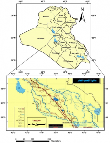
Figure 1 illustrates the MOD location and Table 1 explains the average flow rate at the period 2019-2021 [2]. This study aims to cultivate the largest possible area in Mesopotamia (between Tigris and Euphrates rivers) by using MOD and rainwater harvesting. Then the WATSUIT Model was used to evaluate the salinity effects of saline water. WASUIT is a computer program that forecasts the salinity, sodicity, and toxic-solute concentration of the soil-water inside a simulated crop root zone [17]. The inputs that used to operate the WATSUIT Model are the salinity expressed by the anions, cations (me L-1), also the amendments and leaching fractions are important inputs to that model.
Figure 1. MOD in Iraq [18]
2.1 The study limitations
The soil salinity is within the acceptable values. The rainfall depth in the study area is within the isohyet lines for Iraq that are expressed in Figure 2. The interpolation of isohyet map for the area around the MOD is about 120 mm as an average. There is no significant variation in MOD quality and quantity, the annual average discharge is 150 m3 s-1, the salinity average is 4.4 dS m-1.
2.2 Irrigation water requirements
To sustain the irrigated area around the MOD path, in this study, the irrigation periods was taken from (15/4 to 15/9), so the average discharge for these months were taken to estimate the validity of irrigation water quantities. In other period from (15/9-15/4), the rainwater harvesting technique is used to irrigate orchards, if there are low quantities of rainfall in any year, other MOD water will be discharged to cover the water requirements in that time.
The design discharge of MOD syphon at Theyqar is about 200 m3 s-1. As there are no sufficient available data about the stream flow, the average MOD discharge is assumed to be 75% of the design flow, and recommend to not use greater than 50% of this discharge. Table 1 explains crop water requirements for the selected trees (palm and olives) data were taken from Ministry of Water Resource for the year 2019 [19].
Figure 2. Map of isohyet lines
Table 1. Net irrigation depth in (mm)
|
Crops |
Sep. |
Oct. |
Nov. |
Dec. |
Jan. |
Feb. |
|
Olives |
123 |
84 |
0 |
21 |
0 |
46 |
|
Palm |
170 |
116 |
9 |
29 |
0 |
67 |
|
Crops |
Mar. |
Apr. |
May |
Jun. |
Jul. |
Aug. |
|
Olives |
49 |
82 |
164 |
203 |
215 |
192 |
|
Palm |
83 |
129 |
232 |
280 |
289 |
256 |
Total water requirements depth from 15 April to 15 September: Palm = 1.21 m, Olive = 0.88 m.
Qaverage = 75% of design discharge of the siphon structure:
Qaverage $=200 * \frac{75}{100}=150 \mathrm{~m}^3 / \mathrm{s}$ (1)
$A_{i=} V_{M O D} / D$ (2)
where,
Ai = Irrigated area;
D = depth of irrigation water requirements.
2.3 Rainfall harvesting
The average rainfall depth in the MOD watershed can be forecasted by using the isohyet line map (Figure 2). The map of isohyet lines shows that the study region is located between lines 100 mm and 150 mm. The annual rainfall depth in this watershed is about 120 mm [20].
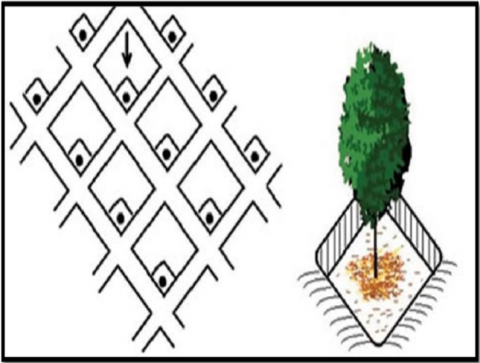
Figure 3 explains the negarim shape of the rainwater harvesting method. The area of the negarim estimated as an area can collect a sufficient rainwater during rainfall season. This area depends on annual rainfall depth. The annual rainfall depth in this watershed is about 120 mm. Although the greatest challenge is Iraq, one of the five countries that is the most affected by climate change in Asia, according to United Nation recommendations, but in general, the average annual rainfall can be considered as a constant in quantity but fluctuating as annual depth [21].
Considering the distance between the trees is 6 m, the area of the planting unit is 36 m2. As for the area achieved using rainwater harvesting, it reached 267 m2 for palms and 164 m2 for olives, so the cultivated area using MOD water is as follows:
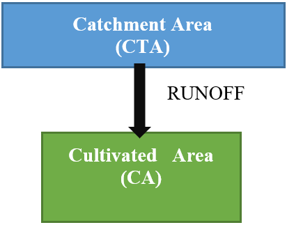
The water harvesting in arid areas means the collection of rainwater from a wide area named as Catchment Area (CTA), to convey it in a small area that surrounds the irrigated tree named as Cultivated Area (CA) (see Figure 3 and Figure 4).
Figure 3. Negarim micro-catchments for tree crops [22, 23]
Figure 4. CAT and CA
$\frac{C T A}{C A}=\frac{I_d-R f_d}{R F_d * R O_c * A c_c}$ (3)
where,
$I_d$: Irrigation water depth;
$R f_d$: Rainfall depth;
$R O_c$: Runoff coefficient;
$A c_c$: Activity coefficient.
To calculate the CA for palm and/or olive, the planted area assumed to be a circle of 2 m diameter, so CA was calculated as 3.14 m2. As we consider that the runoff coefficient is 0.3 and the activity coefficient is 0.5, the catchment unit area can be calculated according to the following equation [21]. The irrigated area under rainwater harvesting technique is estimated according to Eq. (4).
$A_h=\frac{C T A}{U A} * A_a$ (4)
where,
$A_h$: The area irrigated by rainwater harvesting;
$A_a$: The actual irrigated area without harvesting;
$U A$: The square area of four adjacent trees in the orchard, it is assumed to be 6×6 m2 in this study.
2.4 Forecasting soil salinity
To forecast the steady state condition of the soil salinity after using MOD water in irrigation, the WATSUIT program was applied. Table 2 explains the salinity of ADW in the study area (MOD) for many years of the period 1994-2021.
Table 2. EC, cations and anions for the MOD in Abu-Ghraib for period 1994-2021 [22-24]
|
Symbol |
Unit |
1994 |
2009 |
2012 |
2019 |
2021 |
|
EC |
dS/m |
6.9 |
5.7 |
4.9 |
4.7 |
4.4 |
|
Ca+2 |
meq/l |
14.9 |
9.2 |
10.8 |
10.2 |
10.2 |
|
Mg+2 |
meq/l |
27.3 |
17.6 |
16.0 |
13.6 |
13.1 |
|
Na+ |
meq/l |
51.2 |
35.7 |
26.1 |
19.3 |
18.9 |
|
K+ |
meq/l |
- |
0.3 |
0.3 |
0.2 |
0.2 |
|
Cl- |
meq/l |
41.4 |
29.4 |
20.0 |
15.2 |
15.1 |
|
SO4-2 |
meq/l |
49.0 |
26.0 |
26.4 |
25.3 |
25.0 |
|
HCO3- |
meq/l |
3.2 |
3.2 |
3.6 |
4.2 |
3.2 |
The ADW volume discharge from MOD for irrigation period from 15/4 to 14/9 assumed as 75% of syphon discharge, and calculated as below:
$\begin{gathered}V_{A D W}=Q_{\text {average }} * T \\ Q_{\text {average }}=150 \mathrm{~m}^3 \mathrm{~s}^{-1} \\ T=183 \text { days } * \frac{24 h r}{\text { day }} * 3600 \mathrm{~s} / \mathrm{hr} \\ V_{A D W}=150 * 15811200=2.372 * 10^9 \mathrm{~m}^3\end{gathered}$
Green belt width (GBW)
As we assume, using 30% of MOD flow to irrigate the green belt in order to save the ecosystem and encourage the use of the MOD for boat shipping as well. So the water volume used in irrigation is:
$V_{A D W} \times 30 \%=7.115 \times 10^8 \mathrm{~m}^3$
Use half volume of ADW for palm and half for olive.
Half volume $=3.558 \times 10^8 \mathrm{~m}^3$
From Table 1, total water requirement depths from 15 September to 15 April are: Palm = 1210 mm, Olive = 884 mm.
The annual rainfall depth is about 10% of the irrigation depth in this season, so the leaching fraction (LF) is selected as 10% and assumed it is a rainfall water. By applying Eq. (2) and assuming orchard of 6×6 m spacing between adjacent trees:
$\begin{gathered}Area \,\, Planted \,\, by \,\, Palm=\frac{3.558 * 10^8}{1.21}=294049586 \mathrm{~m}^2 \\ =29,405 \text { Hectares }\end{gathered}$
Applying Eq. (2) to find the CTA of one tree:
$\frac{C T A}{3.14}=\frac{1210-120}{100 \times 0.3 \times 0.5}$
CTA=228 m2, that means the nigaream shape area for palm is 228 m2. Applying Eq. (4) to estimate the total palm orchard areas:
$A_h=\frac{228}{36} * 29,405=186,225$ Hectares
$Area \,\, Planted \,\, by \,\, Olive=\frac{3.558 * 10^8}{0.88}=40,432$ Hectares
Applying Eq. (3) to find the CTA of one tree:
The nigaream shape area for palm=160 m2. Applying Eq. (4) to estimate the palm orchard area.
$A_h=\frac{160}{36} * 40,432=179,693$ Hectares
Total orchards areas = 365,918 Hectares = 3659.18 km2.
As the MOD length is 526 km, then the average width of green belt (GBW) is estimated:
$G B W=3659.18 / 526=6.957 \mathrm{~km}$
Using saline water in irrigation may reduce the accumulated evapotranspiration by a ratio of 40% according to updated studies about the osmotic effects on evapotranspiration. Therefore, the irrigated area amount is increased by the same ratio. Table 3 explains the palm and olive orchards areas under different irrigation conditions. It means that the green belt width irrigated by ADW ($G B W_{A D W}$) is 40% wider than the width irrigated by the same volume of high-quality river water. Therefore this green belt width is estimated as:
$G B W_{A D W}=G B W_{R W}+0.4 * G B W_{R W}$ (5)
where, GBWRW is green belt width if irrigated by a same volume of high quality river water.
$G B W_{A D W}=6.956 * 1.4=9.739 \mathrm{~km}$
Table 3. Irrigated area for palm and olive in hectare
|
Trees |
Irrigated by River Water (A1) |
Irrigated by ADW $A_2=A_1 * 1.4$ |
|
Palm |
186,225 |
260,715 |
|
Olive |
179,693 |
251,570 |
|
Total orchards areas |
365,918 |
512,285 |
As the average land size of a farm in Iraq is 6 hectares, this proposed program of using ADW and RWH creates about (85,371) farms if only 30% of ADW is used.
With an average of 5.7 family members in Iraq [24], this farming program can accommodate 486,616 (roughly half a million) people. Using the concept of an Integrated Renewable Energy Farm (IREF) [25], these families can build environmentally friendly homes equipped with solar and biomass energy in order to further contribute to a green environment coexisting with climate change challenges. Also recycling domestic water is a useful tool to minimize both energy and water consumption.
The amount of anions and cations in MOD is shown in Table 4. The annual rainfall depth is about 120 mm, which is about 10% of the water requirements of olive and palm trees. Assuming that the salinity of rainwater is zero, so the average water salinity is 90% of the salinity of MOD water according to the salt balance equation [17]. The anions, cations leaching fraction, and amendments are the WATSUIT program inputs [26].
Table 4. Cations and anions in MOD stream (me L-1)
|
No. |
Cations |
Anions |
||
|
1 |
Ca+2 |
10.2 |
CO3- |
0 |
|
2 |
Mg+2 |
13.1 |
Cl- |
15.1 (14.2)* |
|
3 |
Na+ |
18.9 |
SO4-2 |
25.0 |
|
4 |
K+ |
0.2 |
HCO3- |
3.2 |
|
Summation |
42.4 |
|
43.3 |
|
|
Balancing by adding or subtracting Cl- |
|
|
-0.9 Cl- |
|
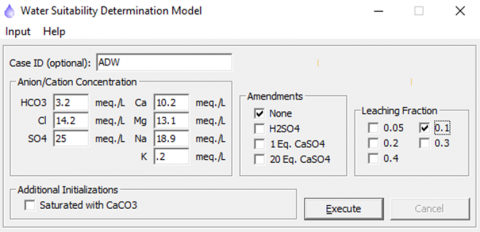
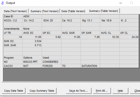
Applying the WATSUIT program using this data as input, the face of the model input data is shown in Figure 5, the result of the salinity distribution in the soil column as a quarter of root zone depth is seen in Figure 6. The values of average EC and the EC of the upper root zone half of all LF scenarios contained in the WATSUIT model (0.05, 0.1, 0.2, 0.3 and 0.4) are listed in Table 5. These LF value were proposed according to the water salt balance equations in order to mitigate the soil water against the salinity effects of irrigation water, as the irrigation water salinity increased, the required leaching (LF) also increased. The LF must be not exceed 40% of crop water requirement [17]. The results explain that the increase of LF levels decreases EC values very little in the half of the upper root zone, but notable reductions were observed in the average EC values. The trend of EC decreasing is started very sharp, (from 20.19 to 14.77 dS m-1 in first step) then be smoothly decreasing as shown in the last step (from 9.81 to 7.78 dS m-1). These results were consistent with the findings of previously studied researchers of optimal leaching fraction values [27]. The rainwater reduces the salinity effects of MOD water as the average annual rainfall depth (about 10% of crop water requirements) [28]. That’s why the rainfall was assumed as the leaching value (0.1). This study recommend to use LF value of 0.1 because the steady state condition of the soil salinity is within the acceptable values recommended to the palm and olive trees salinity tolerance, it is also suitable for high tolerance winter crops like wheat and barley.
As the salinity of these areas is high, so the irrigation using moderate saline water and rainwater harvesting may decrease soil salinity values. We recommend using this technique to expand orchards in this region [29].
The farmers, engineers and decision-makers have to observe the weather conditions, especially annual rainfall depth, humidity and evaporation losses. An advanced infrastructure such as an advanced weather station network must be designed and applied in this region [30].
Table 5 provides a summary of the WATSUIT model’s primary input and output parameters.
Table 5. The effect of leaching fraction (LF) ratios on EC values
|
|
LF |
|||||
|
0.05 |
0.1 |
0.2 |
0.3 |
0.4 |
||
|
EC dS m-1 |
Upper half zone |
6.14 |
5.82 |
5.37 |
5.06 |
4.75 |
|
Average |
14.64 |
11.05 |
8.24 |
6.92 |
6.02 |
|
Figure 5. Input data (selecting LF=0.1 in this stage)
Figure 6. Result of WATSUIT, LF=0.1
The green belt area: The area planted by palm and olive is about 500,000 hectares by using 30% of MOD discharge. The green belt width is about 9.74 km.
The soil salinity: Using WATSUIT model explains that the soil salinity at steady state condition of using ADW within the range of the tolerance of orchards and high tolerance crops as barley. Proposed management for sustainability:
The ADW program in the MOD watershed can habitat about half a million people in a green environment under the concept of Integrated Renewable Energy Farm (IREF) using renewable energy and recycling domestic water (RDW). Many studies are consistent with this conclusion [30].
The authors recommend dividing the proposed green belt area into ten locations, 52.5 km for each one, and planting as a five stages in five years, planting 10.5 km every year.
Planting some areas among the palm and olive orchards by high tolerance crops as barley, and irrigate it by river water to maintain the soil salinity within the acceptable range for planting crops.
Great thanks and gratitude to the Iraqi Ministry of Higher education and Scientific Research for providing this opportunity for me to work with colleagues at the University of Ankara, Türkiye. Authors thank the Faculty of Agriculture at the University of Ankara for the facilities it provided for the completion of this study; also thank University of Anbar for this opportunity.
[1] Maas, E.V. (1993). Testing crops for salinity tolerance. In Proceedings of the Workshop on Adaptation of Plants to Soil Stresses, Nebraska, 94: 234-247.
[2] Abdulhameed, I.M., Malloki, H.N. (2021). Saline irrigation water matrix (SIWM) to optimize crop productivity: A review. IOP Conference Series: Earth and Environmental Science, 779: 012025. https://doi.org/10.1088/1755-1315/779/1/012025
[3] Tabari, H. (2020). Climate change impact on flood and extreme precipitation increases with water availability. Scientific Reports, 10(1): 13768. https://doi.org/10.1038/s41598-020-70816-2
[4] Patel, P., Patel, A. (2021). Low cost model for desalination of water using solar energy to overcome water scarcity in India. Materials Today: Proceedings, 47: 1409-1415. https://doi.org/10.1016/j.matpr.2021.02.804
[5] Boretti, A., Rosa, L. (2019). Reassessing the projections of the world water development report. NPJ Clean Water, 2(1): 15. https://doi.org/10.1038/s41545-019-0039-9
[6] Abdulhameed, I.M., Sulaiman, S.O., Ahmed Najm, A.B., Al-Ansari, N. (2022). Optimising water resources management by Using Water Evaluation and Planning (WEAP) in the West of Iraq. Journal of Water and Land Development, 53: 176-186. https://doi.org/10.24425/jwld.2022.140795
[7] Kim, H., Jeong, H., Jeon, J., Bae, S. (2016). Effects of irrigation with saline water on crop growth and yield in greenhouse cultivation. Water, 8(4): 127. https://doi.org/10.3390/w8040127
[8] Abdullah, M., Al-Ansari, N., Laue, J. (2019). Water resources projects in Iraq: Main drains. Journal of Earth Sciences and Geotechnical Engineering, 9(4): 275-281.
[9] Mateo-Sagasta, J., Burke, J. (2011). Agriculture and water quality interactions: A global overview. SOLAW Background Thematic Report - TR08, 46.
[10] Ashu, A., Lee, S.I. (2018). Reuse of agriculture drainage water in a mixed land-use watershed. Agronomy, 9(1): 6. https://doi.org/10.3390/agronomy9010006
[11] Epstein, E., Norlyn, J.D., Rush, D.W., Kingsbury, R.W., Kelley, D.B., Cunningham, G.A., Wrona, A.F. (1980). Saline culture of crops: A genetic approach. Science, 210(4468): 399-404. https://doi.org/10.1126/science.210.4468.399
[12] Glenn, E., Hicks, N., Riley, J., Swingle, S. (1996). Seawater irrigation of halophytes for animal feed. Halophytes and Biosaline Agriculture, 221-235.
[13] Glenn, E., Miyamoto, S., Moore, D., Brown, J.J., Thompson, T.L., Brown, P. (1997). Water requirements for cultivatingSalicornia bigeloviiTorr. with seawater on sand in a coastal desert environment. Journal of Arid Environments, 36(4): 711-730. https://doi.org/10.1006/jare.1997.0253
[14] Coping with water scarcity - UN-water thematic initiatives. https://www.un.org/waterforlifedecade/pdf/2006_unwater_coping_with_water_scarcity_eng.pdf.
[15] World Health Organization (WHO). (2006). Guidelines for the Safe Use of Wastewater, Excreta and Greywater, Volume 2: Wastewater Use in Agriculture; World Health Organization: Geneva, Switzerland.
[16] Hamilton, A.J., Stagnitti, F., Xiong, X., Kreidl, S.L., Benke, K.K., Maher, P. (2007). Wastewater irrigation: The state of play. Vadose Zone Journal, 6(4): 823-840. https://doi.org/10.2136/vzj2007.0026
[17] The use of saline water for crop production - irrigation and drainage paper No. 48. https://www.ars.usda.gov/arsuserfiles/20361500/pdf_pubs/P1313.pdf, accessed on Feb. 15, 2024.
[18] Malloki, H.N. (2021). Programming the use of main outfall drain water for irrigation. MSc dissertation. Dams and Water Resources Engineering Department, University of Anbar.
[19] Najm, A.B.A., Al-bayati, I.M.A., Sulaiman, S.O. (2021). Improving the cultivated area for the ramadi irrigation project by using Water Evaluation and Planning model (WEAP). Al-Rafidain Engineering Journal (AREJ), 26(1): 105-114.
[20] Al-Salihi, Z.A., Kamel, A.H., Abdulhameed, I.M. (2022). Effects of the Climate Change on the Tigris River Basin in Iraq. International Journal of Design & Nature and Ecodynamics, 17(4): 585-593. https://doi.org/10.18280/ijdne.170413
[21] Shahadha, S.S., Salih, R.M. (2021). Assessment of the water suitability of the main outfall drain river for irrigation purposes in Iraq: Case study. Iraqi Journal of Soil Science, 21(1): 146-153.
[22] Mati, B.M. (2006). Overview of Water and Soil Nutrient Management under Smallholder Rain-Fed Agriculture in East Africa. IWMI.
[23] Abdulhameed, I.M., Alhadeethi, I.K., Jabir, A.A., et al. (2022). Guideline of Iraqi valleys development. Upper Euphrates Basin Developing Center.
[24] Annually Report 2021. Ministry of Planning, Republic of Iraq. https://mop.gov.iq/en, accessed on Jan. 26, 2024.
[25] Moreno-Munoz, A. (2017). Large Scale Grid Integration of Renewable Energy Sources. The Institution of Engineering and Technology.
[26] Annually Report 2019. Ministry of Water Resources. https://www.developmentaid.org/donors/view/34731/republic-of-iraq-ministry-of-water-resources, accessed on Jan. 26, 2024.
[27] Abdulhameed, I.M. (2017). Maximizing irrigation water productivity by optimizing leaching fraction. Journal of Agricultural Science and Technology A, 7(2017): 73-80. https://doi.org/10.17265/2161-6256/2017.02.001
[28] Ning, S., Zhou, B., Wang, Q., Tao, W. (2020). Evaluation of irrigation water salinity and leaching fraction on the water productivity for crops. International Journal of Agricultural and Biological Engineering, 13(1): 170-177.
[29] Abdulhameed, I.M., Sonay Sozudogru, O.K., Malloki, H.N., Akca, M. O., Omar, B., Cayci, G. (2022). Bio-saline agriculture modeling, using saline water for irrigation purposes. International Journal of Design & Nature and Ecodynamics, 17(6): 951-956. https://doi.org/10.18280/ijdne.170617
[30] Abdulhameed, I.M., Sulaiman, S.O., Najm, A.B.A. (2021). Reuse wastewater by using water evaluation and planning (WEAP) (Ramadi city–case study). IOP Conference Series: Earth and Environmental Science, 779: 012104. https://doi.org/10.1088/1755-1315/779/1/012104