Anak Agung Ayu Wulandira Sawitri Djelantik*![]() | I Made Sudiana Mahendra
| I Made Sudiana Mahendra![]() | I Wayan Windia
| I Wayan Windia![]() | I Made Sudarma
| I Made Sudarma![]()
© 2023 IIETA. This article is published by IIETA and is licensed under the CC BY 4.0 license (http://creativecommons.org/licenses/by/4.0/).
OPEN ACCESS
This study aimed to investigate the driving factors behind functional shifts in rice fields and to assess the contribution of rice field activities to greenhouse gas emissions. Data were collected from 58 respondents, including heads of subak systems, agriculture officers, representatives from the Tabanan Department of Agriculture and Horticulture, and academicians. Leverage analysis, Interpretive Structural Modeling (ISM), and emission calculations using the 2019 IPCC approach were employed, along with time series data from 2016 to 2020. The findings revealed that the primary determinants of functional shifts included pest attacks and diseases, rice field selling prices, availability of production facilities, housing needs and tourism growth in the study area, family participation in rice field management, marketing institutions, enforcement of awig-awig subak (penalties for rice field conversion), and the conditions of irrigation canals and roads to the farming area. Emission analysis, focusing on methane, demonstrated that the reduction in rice field area due to functional shifts between 2016 and 2020 led to a 21.95 percent decrease in greenhouse gas emissions.
functional shift, rice field, greenhouse gas
Agricultural land in Indonesia, particularly rice fields, is undergoing significant functional shifts as the population expands and development progresses. Previous research estimated that 96,512 hectares of rice fields were converted for other purposes between 2000 and 2015 in nine of the country's rice production centers, including West Java, East Java, Bali, West Nusa Tenggara, South Sulawesi, South Kalimantan, South Sumatra, North Sumatra, and Gorontalo [1]. Furthermore, it is projected that the total area of rice fields in these provinces will decline from 8.1 million hectares to just 5.1 million hectares by 2045 [1]. These findings indicate that functional shifts of rice fields in Indonesia are occurring at an alarming rate.
The primary factors driving land conversion include increasing demand for land, rising land prices, poor irrigation conditions, and weak laws and regulations [2-5]. Land conversion is often a response to the growing needs of the population and the desire for improved living conditions, housing, and infrastructure development [6-8]. Functional shifts in high-productivity irrigated areas pose a greater threat to food production sustainability, particularly for staple foods like rice, than shifts in areas with low productivity [9, 10].
Bali, a major rice production center in Indonesia, experienced a 3.13% decrease in rice field area, equivalent to 2,539 hectares, between 2013 and 2017 [11]. In nearly all regencies/cities of Bali, this decline is attributed to land consolidation for infrastructure development, public service facilities, and settlements [12]. Additionally, the conversion of rice fields into unutilized or abandoned land has been linked to limited water resources for rice cultivation, disrupted irrigation canal facilities and infrastructure, and a lack of human resources willing to pursue farming [13].
Tabanan Regency, widely known as a "food barn" and a tourist destination in Bali, has seen a substantial decrease in rice field area, with a reduction of 1,193.54 hectares between 2016 and 2020 [14]. Much of the land has been developed into housing and tourist attractions, as well as supporting facilities such as lodging and restaurants. As rice field areas are repurposed for other functions, land prices continue to rise, encouraging farmers to sell, convert [14], or rent out their rice fields for non-agricultural purposes, as these alternatives offer higher profits than rice production.
While rice fields are essential for providing food, particularly rice as a staple for most Indonesians, rice cultivation practices involving irrigation are also significant sources of greenhouse gas emissions, especially methane (CH4) [15, 16]. The three primary sectors contributing to climate change-inducing emissions are energy, land, and waste, which collectively generated approximately 22.4 million tonnes of CO₂ equivalent in 2010, a figure expected to increase annually [17].
Greenhouse gases produced by the agricultural sector pose a threat to the global climate and environment [18]. Examples of environmental harm include water and soil pollution from chemical use (fertilizers and pesticides) and silting of rivers and irrigation canals during land cultivation [19]. Methane (CH4), a potent greenhouse gas, plays the second most significant role in causing climate change after CO₂ [20]. One molecule of methane in the troposphere has 21 times the warming potential of one CO₂ molecule [21], making it crucial to control its atmospheric concentration.
Flooded or submerged rice fields with irrigated systems create ideal conditions for methane formation, with methane being emitted or channeled into the atmosphere through rice stems [22, 23]. Parenchymal cells in rice stems transport oxygen from the atmosphere to the root zone, creating aerobic conditions for root respiration in flooded soil and CH4 oxidation in the rhizosphere [22, 23].
The present study focuses on Tabanan Regency, where functional shifts of rice fields have been occurring at an increasing rate from 2016 to 2020. The shrinking rice production area raises concerns about food security, making it crucial to identify the driving factors behind functional shifts and develop strategies to better manage land-use changes [24]. Additionally, understanding the contribution of diminished rice field area to greenhouse gas emissions is vital, as methane generated by rice cultivation practices negatively impacts global climate change.
This research purposively selected Tabanan Regency as the study area because it represents the rice production center in Bali Province, Indonesia, that has experienced a substantial areal decrease, i.e., 5.56% in five years from 2016 to 2020 for being allocated into non-agricultural purposes. Tabanan is located about 35km west of Denpasar, the provincial capital. It has a total area of 839.33km² (14.90% of the provincial area) and is bordered by Buleleng Regency to the north, Badung Regency to the east, the Indian Ocean to the south, and Jembrana Regency to the west. In terms of climate, Tabanan has seasonal tropical rain characterized by a rainy season from November to May and a dry season from April to September. The average annual rainfall is about 2,155-3,292mm, with temperatures in the range of 24°C-30°C (average 27°C) and air humidity of 74%-77% [25]. Figure 1 shows the map of Tabanan Regency.
Figure 1. Map of the research location
The research used primary and secondary data. The secondary data were collected from BPS-Statistics Indonesia, the Department of Agriculture, and Agricultural Extension Services for Tabanan Regency, and the primary data were obtained through observations, in-depth interviews, and focus group discussions (FGDs). During observations, the conditions of rice fields in relation to land conversion were directly examined. In-depth interviews with farmers were conducted using questionnaires, and FGDs with relevant informants and key persons were also carried out using interview guidelines that produced numerical data or scores. FGDs aimed to improve data reliability (second-level data), for it also relied on expert judgments from parties well-informed about priority policy strategies planned for different periods (short, medium, and long terms) to control the conversion of rice fields.
The informants in this research were chosen deliberately with two considerations: (1) they had sufficient experience and knowledge regarding the functional shift of rice fields and (2) they were in the relevant position to give information about the research topic, had a good reputation in their field, and showed credibility by providing consistent information. The research involved a total of 58 respondents, consisting of 45 farmers who had converted their rice fields into built-up land and subak farmers and 13 experts from the Tabanan Department of Agriculture and Horticulture, agricultural extension officers, and academics. The farmers were, on average, 55 years old, mostly male (two females), and had attained secondary education at senior high schools or equivalent. The experts were also about 55 years old, male, and had at least a bachelor's degree.
The factors causing the functional shifts of rice fields were determined using leverage analysis. This analysis has wide applications because it uses a universal yet adjustable model in that the attributes of each dimension can be selected specifically to represent the local conditions. In this research, this adjustability is primarily utilized to explain the social aspect developing in Bali. Table 1 shows the five dimensions used in the leverage analysis: ecological, economic, social, institutional, and technological. These dimensions were selected according to the concept of sustainable agriculture described in Law No. 41 of 2009 on the Protection of Sustainable Food Agricultural Land. Each dimension was broken down into several attributes. The dimensions and attributes are both independent (each dimension stands alone).
The leverage analysis examined 36 attributes from five dimensions using Rapid Sustainability Index software (RSI) which is part of the multidimensional scaling approach [26]. This analysis aimed to find sensitive attributes, termed most important or determining factors, that caused the conversion of rice fields as a threat to rice production sustainability. These sensitive attributes were defined based on the order of the percentage of change in the root mean square (RMS) values on the x-axis. The greater the percentage, the greater the role of these attributes in converting rice fields. Furthermore, attributes with the largest RMS values are the most determining factors of the functional shifts.
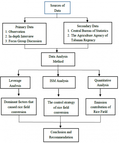
As seen in the research flowchart in Figure 2, the leverage analysis was followed by Interpretive Structural Modeling (ISM) analysis to formulate strategies for controlling the functional shift of rice fields. ISM can capture dynamic complexities by describing or breaking down an abstract problem to make it more structured [9].
Figure 2. Research diagram
Table 1. Dimensions and attributes used in the leverage analysis
|
No |
Dimension |
Attribute |
|
1 |
Ecological |
|
|
||
|
||
|
||
|
||
|
||
|
||
|
2 |
Economic |
|
|
||
|
||
|
||
|
||
|
||
|
||
|
3 |
Social |
|
|
||
|
||
|
||
|
||
|
||
|
||
|
||
|
||
|
4 |
Institutional |
|
|
||
|
||
|
||
|
||
|
||
|
5 |
Technological |
|
|
||
|
||
|
||
|
||
|
The amount of methane gas emitted from rice farming practices was calculated using the 2019 IPCC approach (Tier 2) based on time series data on changes in the harvested area from 2016-2020. It was derived by multiplying activity data and GHG emission factors. The activity data used were different water regimes before and during the cultivation period, soil types, and rice varieties.
3.1 Leverage analysis
The leverage analysis showed ten attributes with the largest root mean square (RMS) values in each dimension. These sensitive attributes, or determining factors, had the most influence on the functional shift of rice fields and could exert pressure on future rice farming sustainability in Tabanan. The attributes in question were (E1) pest attacks and diseases that caused damage to rice farming; (E2) the selling price of rice fields; (E3) available production facilities; (E4) housing needs; (E5) tourism growth in the research area; (E6) family participation in managing rice fields; (E7) available marketing institutions; (E8) the enforcement of awig-awig subak (penalties for rice field conversion); (E9) the condition of irrigation canals, and (E10) the condition of roads to the farming area.
3.1.1 Ecological dimension
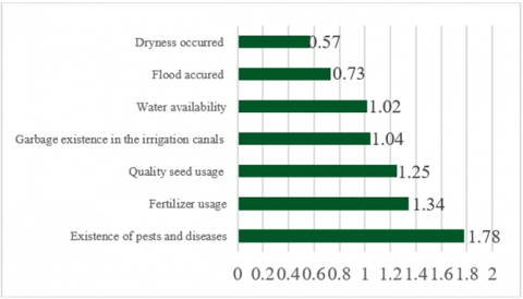
The ecological dimension in this research used seven attributes: (1) pest attacks and diseases, (2) the use of fertilizers, (3) rice seed quality, (4) water availability, (5) waste in irrigation canals, (6) drought occurrences, and (7) flood occurrences. The leverage analysis results for the entire ecological dimension are shown in Figure 3.
Figure 3. Attributes of the ecological dimension of rice field preservation and their root mean square (RMS) values
From the ecological dimension, one attribute had the largest RMS value of 1.78, namely pest attacks and diseases. This attribute is the determining factor of the functional shift of rice fields in the research area. Pest attacks and diseases cause the most damage to rice farmers because they reduce yields and may even lead to crop failure. The most common pests of rice in Tabanan Regency are rats, leafhoppers, insects, and crabs [27].
3.1.2 Economic dimension
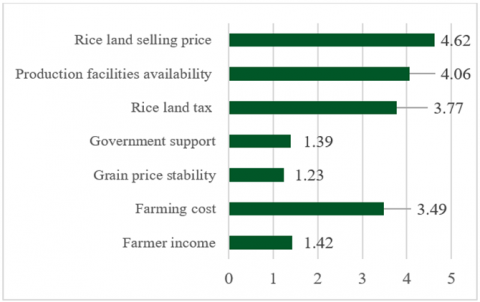
The economic dimension in this research also used seven attributes: (1) farmer’s income, (2) farming costs, (3) grain price stability, (4) government supports, (5) land tax for rice field, (6) available production facilities, and (7) the selling price of rice fields. The leverage analysis results for the economic dimension are presented in Figure 4.
Figure 4. Attributes of the economic dimension of rice field preservation and their RMS values
The economic dimension had two attributes with the largest RMS values: the rice field’s selling price and available production facilities. Both attributes are the determining factors of the functional shift of rice fields in the research area. The rice fields in Tabanan Regency are offered at a relatively high price of up to IDR500,000,000 per acre, especially the plots located close to highways and tourist attractions where extensive functional shifts of rice fields occurred. Both objects and the development that ensued are enticing farmers who are also landowners to sell or convert their rice fields because these options are considered more profitable than rice farming. Suamba et al. [28] proposed preserving rice fields with an agrotourism system, which is expected to prevent land conversion while increasing the local community’s economy.
Limited production facilities for farming resources, especially inorganic fertilizers like Urea and NPK, are another reason rice farmers abandon agricultural activities. Urea and NPK are required to produce favorable yields, but instead of self- or co-producing, farmers have to buy their entire fertilizer supplies. With unstable availability, scarcity of fertilizers in the market tends to lead to high prices, thus increasing farming costs.
3.1.3 Social dimension
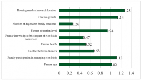
The social dimension in this research used nine attributes: (1) the age of the farmer, (2) family participation in managing rice fields, (3) conflicts between farmers, (4) farmer's health, (5) farmer’s knowledge of the impact of rice field conversion, (6) farmer's education level, (7) the number of dependent family members, (8) tourism growth, and (9) housing needs. The leverage analysis results for this social dimension are depicted in Figure 5.
From the social dimension, three attributes had the largest RMS values: housing needs, tourism growth, and family participation in managing rice fields. These attributes are the determining factors behind the functional transitions of rice fields in Tabanan. With the growing number of immigrants and local residents in Tabanan, there is an increasing need for new settlements, the space for which is often provided by converting rice fields. Similarly, this causal relationship is also explained in Lulan et al. [29] based on findings in several districts on Timor Island, East Nusa Tenggara, Indonesia, where rice fields have been converted into new settlements to accommodate residents in the region. In addition, rice fields in Tabanan are converted to develop tourism-supporting facilities such as hotels and villas because Tabanan is also one of the most visited tourist destinations in Bali [30]. Another significant challenge in sustaining rice fields’ production function is associated with the lack of regeneration of farmers and government’s attention to farmers’ welfare, making fewer younger family members engage in agriculture [31]. The low participation of families/next generations in managing rice fields makes it difficult to guarantee future rice production sustainability [32].
Figure 5. Attributes of the social dimension of rice field preservation and their RMS values
3.1.4 Institutional dimension
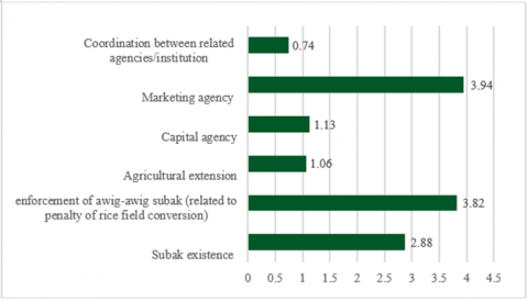
In this research, the institutional dimension used six attributes: (1) available subak system, (2) enforcement of awig-awig subak, (3) agricultural extension, (4) capital/resource provision institutions, (5) marketing institutions, and (6) coordination between related institutions/agencies. The leverage analysis results of the institutional dimension are shown in Figure 6.
Figure 6. Attributes of the institutional dimension of rice field preservation and their RMS values
The institutional dimension had two attributes with the highest RMS values: available marketing institutions and the enforcement of awig-awig subak (penalties for rice field conversion). These sensitive attributes are the determining or most important factors behind farmers’ choice to sustain or change the production function of their rice fields. Marketing institutions that stand with producers/farmers and specifically give spaces for them to sell their products are expected to substantially improve farmers’ welfare and promote the success of agribusiness [33]. The agricultural sector in Bali, especially food crops, cannot be separated from the long-standing subak system, which is part of the socio-agricultural-religious interaction that has now developed into an institutional arrangement to manage water and other elements of rice farming. However, subak has yet to reduce the conversion rate because there are no written or unwritten rules regarding the functional shift of rice fields, thus creating challenges in the existence and implementation of subak in the future [34].
3.1.5 Technological dimension
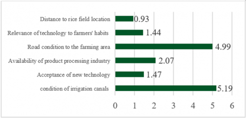
In this research, the technological dimension used six attributes, consisting of (1) irrigation canal conditions, (2) acceptance of new technologies, (3) availability of product processing industry, (4) the road condition to the farming area, (5) the relevance of technology to farmers' habits, and (6) the distance to rice fields. The leverage analysis results for the technological dimension are presented in Figure 7.
From the technological dimension, two attributes had the highest RMS values: the conditions of irrigation canals and roads to the farming area. These sensitive attributes are the determining factors of the functional shift of rice fields. The irrigation canals in Tabanan Regency are moderately to heavily damaged. Heavy damages are often associated with the impact of landslides (i.e., collapses) and leaks at several locations. In addition, the road access to the rice field location is mostly inadequate or even non-existent. In the majority, farmers can access the area through footpaths, which are usually difficult to pass during rainy seasons and are thus believed to be a specific challenge in rice farming [35, 36]. To deal with these challenges, it is encouraged to adopt technology that promotes fast exchange of information between farmers, stakeholders, and the public. The needed information, e.g., farming activities and existing facilities on rice fields, can be obtained and presented using mapping technologies [37, 38].
Figure 7. Attributes of the technological dimension of rice field preservation and their RMS values
3.2 Strategies to control rice field conversion
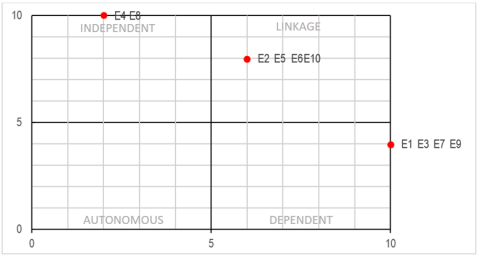
The ISM (Interpretive Structural Modeling) analysis in this research was used to obtain the structure or stages of strategies for controlling rice field conversion in Tabanan Regency. Based on the leverage analysis, there are ten determining factors of the conversion. The ISM analysis partitioned these factors into several levels and produced a matrix describing the level of influence and dependence between factors. The matrix classifies each factor into one of the four quadrants: linkage, dependent, autonomous, or independent.
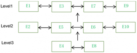
The factor partitioning in Figure 8. divides the ten determining factors of the rice field conversion into three levels: 1, 2, and 3, and each level was plotted into the matrix in Figure 9. Factors E4 and E8 were located at level 3 and in the independent quadrant. This quadrant represents a key (dominant) factor behind the functional shift of rice fields in the research area that exerts a strong driving force (see the horizontal axis) and weak dependence (vertical axis). Factors E2, E5, E6, and E10 were at level 2 and in the linkage quadrant, which has weak driving power but strong dependence. Factors E1, E3, E7, and E9 were at level 1 and in the dependent quadrant, which has a strong driving force and dependence.
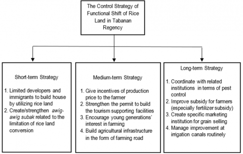
From these results, the strategies to control the functional shifts were broken into three stages according to the level and position of the determining factors. The short-term strategy is aimed at challenges related to level-3 attributes or determining factors, the medium-term is for level-2 factors, and the long-term is for level-1 factors. These strategies are described in Figure 10.
The short-term strategies include restricting developers and immigrants from converting rice fields into settlements and creating/enforcing the awig-awig subak regulation that is related to limiting the functional shift of rice fields. These strategies should be implemented first and immediately because they are focused on dealing with the key driving factors behind the shift. Implementing restrictions to regulate permanent stay for immigrants can minimize the development of new housing areas in Tabanan Regency. Rules or awig-awig should be enforced to prevent farmers from converting their rice fields and regulate penalties for those failing to obey the rules. Awig-awig is believed to help reduce the conversion of rice fields.
Figure 8. Ten determining factors of the functional shift of rice fields partitioned into three levels
Notes:
E1: pest attacks and diseases that disturb rice farming
E2: rice land’s selling price
E3: available production facilities
E4: housing needs
E5: tourism growth in the research area
E6: family participation in managing rice fields
E7: available marketing institutions
E8: enforcement of awig-awig subak (related to penalties for changing the production function of rice fields)
E9: conditions of irrigation canals
E10: conditions of roads to the farming area
Figure 9. Matrix linking the level of influence of the determining factors to the degree of their interdependence
Figure 10. Strategies to control functional shifts of rice fields in Tabanan regency divided into short, medium, and long terms
The medium-term strategies involve providing incentives for farmers, creating stricter permits to build tourism-supporting facilities, raising the younger generation's interest in farming, and building agricultural infrastructure, e.g., agricultural roads or farm tracks. In addition, considering the high selling price of rice fields, future land sales can be prevented by providing incentives such as tax relief for rice fields. Creating stricter permits to build supporting facilities around tourist attractions and establishing and consistently enforcing green lanes are expected to minimize the conversion of rice fields. In addition to farm tracks, the first adopted strategy to awaken the desire of the younger generation to become farmers and eventually improve farmers’ welfare is by enhancing their knowledge of subak in particular and rice fields in general.
The long-term strategies consist of coordinating with relevant agencies to control pests and diseases, increasing subsidies for farmers (especially fertilizers), establishing a grain marketing institution, and performing regular maintenance of irrigation channels. The government is expected to provide more subsidies for production facilities, especially fertilizers, to reduce the production costs that farmers incur and, at the same time, increase their income. A marketing institution needs to be established to accommodate farmers in selling their grain at a more profitable price.
3.3 Emission contribution of rice fields
The functional shift of rice fields in Tabanan in the 2016-2020 period decreased the rice production and harvested areas. The calculation of greenhouse gas emissions, especially methane, using the 2019 IPCC (Tier 2) method showed that the decreased harvested area reduced the amount of methane gas produced. Table 2 shows the contribution of rice fields to methane gas emissions in Tabanan from 2016 to 2020.
Table 2. Contributions of methane gas emissions from rice fields in Tabanan regency in the 2016-2020 period
|
No |
Year |
Harvested Area (Ha/year) |
Methane Emission (Gg CH4 /year) |
Methane Emission (tonne CO2 -eq/year) |
|
1 |
2016 |
32,374 |
1.572 |
44,016 |
|
2 |
2017 |
36,810 |
1.786 |
50,008 |
|
3 |
2018 |
32,172 |
1.562 |
43,736 |
|
4 |
2019 |
26,607 |
1.292 |
36,176 |
|
5 |
2020 |
25,270 |
1.227 |
34,356 |
In 2016, the amount of methane gas emitted from a harvested area of 32,374 hectares was 1,572Gg CH4/year or 44,016 tonnes CO2-eq/year, which then decreased to 1,227Gg CH4/year or 34,356 tonnes CO2-eq/year in 2020 because the harvested area also narrowed to 25,270 hectares. The shrinking of the harvested area by 7,104 hectares (21.94%) within the course of five years reduced the amount of methane gas emission by 9,660 tonnes CO2-eq/year (21.95%). From these calculations, it can be inferred that the decreased contribution of methane gas emission from rice fields generally occurs in tandem with a decrease in the harvested area. This finding is in line with Pratiwi et al. [39] which stated that the decline in the harvested area of rice fields in Prabumulih City, South Sumatra, Indonesia, due to their conversion into non-agricultural land also reduces the amount of the methane gas released by rice fields. In other words, reducing the rice field area helps diminish greenhouse gas emissions.
There are many driving factors behind the functional shifts of rice fields in Tabanan, Bali. However, the determining factors are pest attacks and diseases, the selling price of rice fields, available production facilities, housing needs and tourism growth in the research area, family participation in managing rice fields, available marketing institutions, the enforcement of awig-awig subak (penalties for the functional shift), and conditions of irrigation canals and roads to the farming area.
To control the rate of the functional shift, there are three types of strategies that can be implemented: short, medium and long-term strategies. The short-term strategies include restricting developers and immigrants from converting rice fields into settlements and building/strengthening the awig-awig subak that is related to limiting the functional shift of rice fields. The medium-term strategies are providing incentives to farmers, creating stricter permits to build tourism-supporting facilities, raising the younger generation’s interest in farming, and building agricultural infrastructure such as farm tracks. The long-term strategies involve coordinating with relevant agencies to control pests and diseases, increasing subsidies for farmers (especially for fertilizers), creating a special marketing institution for grain sale, and regularly maintaining/improving irrigation canals. In terms of contributions to greenhouse gas emissions, a decrease in the harvested area due to the functional shift from 2016 to 2020 also reduced the amount of methane released from rice fields by 9,660 tonnes CO2-eq/year or 21.95%.
This work is supported by the Department of Agribusiness, Faculty of Agriculture, and the Doctoral Program on Environmental Science, Udayana University, Indonesia.
[1] Mulyani, A., Kuncoro, D., Nursyamsi, D., Agus, F. (2016). Analisis konversi lahan sawah: Penggunaan data spasial resolusi tinggi memperlihatkan laju konversi yang mengkhawatirkan. Jurnal Tanah dan Iklim, 40(2): 121-133.
[2] Irawan, B. (2005). Konversi lahan sawah: Potensi dampak, pola pemanfaatannya, dan faktor determinan. Forum Penelitian Agro Ekonomi, 23(1): 1–18.
[3] Widhianthini, A.H.D., Achsani, N.A., Hadi, S. (2016). Keterlibatan para aktor dalam pengendalian konversi lahan pertanian (studi kasus di kabupaten tabanan, provinsi bali). Jurnal Sosiologi Pedesaan, 2(1): 11-22.
[4] Wulandari, Y.A., Hartadi, R., Sunartomo, A.F. (2017). Analysis of factors affecting decisions farmers are conversing land and fishings impact on farmers’ revenues (case study of wetland rice conversion in kecamatan kaliwates kabupaten jember). Jurnal Agribest, 01(02): 152-167. https://doi.org/10.32528/agribest.v1i2.1154
[5] Nurliani, Rosada, I. (2016). Rice-field conversion and its impact on food availability. Agriculture and Agricultural Science Procedia, 9: 40-46. https://doi.org/10.1016/j.aaspro.2016.02.121
[6] Winoto, J. (2005). Kebijakan pengendalian alih fungsi tanah pertanian dan implementasinya. Prosiding Seminar Penanganan Konversi Lahan dan Pencapaian Lahan Pertanian Abadi. Institut Pertanian Bogor Press.
[7] Lestari, T. (2005). Dampak konversi lahan pertanian bagi taraf hidup petani. Institut Pertanian Bogor Press.
[8] Pasandaran, E. (2006). Alternatif kebijakan pengendalian konversi lahan sawah beririgasi di indonesia. Jurnal Litbang Pertanian, 25(4): 123-129.
[9] Darmawan, D.P. (2017). Pengambilan keputusan terstruktur dengan interpretive structural modeling. Penerbit Elmatera.
[10] Pudjiastuti, A.Q., Arisena, G.M.K., Krisnandika, A.A.K. (2021). Rice import development in Indonesia. SOCA: Jurnal Sosial Ekonomi Pertanian, 15(2): 390-405. https://doi.org/10.24843/SOCA.2021.v15.i02.p14
[11] Dinas Pertanian Tanaman Pangan Provinsi Bali. (2019). Luas lahan sawah di provinsi bali tahun 2013-2017.
[12] Darmawan, D.P., Arisena, G.M.K., Utami, N.W.F., Krisnandika, A.A.K. (2021). The dynamics of the social network of urban farmers in subak sembung denpasar. AGRIS On-Line Papers in Economics and Informatics, 13(665-2022-458): 51-58. http://doi.org/10.22004/ag.econ.320257
[13] Budiasa, W. (2011). Upaya pengendalian alih fungsi lahan sawah untuk pelestarian subak dan keberlanjutan pertanian di baliâ€. Dwijenagro, 2(2).
[14] Sudarma, I.M., Windia, W., Dwipradnyana, M., Made, I. (2015). Faktor-faktor yang mempengaruhi konversi lahan serta dampaknya terhadap kesejahteraan petani: Kasus di subak jadi, kecamatan kediri, kabupaten tabanan. Jurnal Manajemen Agribisnis, 3(1): 26291.
[15] Badan Perencanaan Pembangunan Nasional (Bappenas). (2014). Pedoman teknis penghitungan baseline emisi dan searapan gas rumah kaca sektor berbasis lahan. Buku I: Landasan Ilmiah. Deputi Bidang Sumberdaya Alam dan Lingkungan Hidup Bappenas.
[16] Nazaries, L., Murrell, J.C., Millard, P., Baggs, L., Singh, B.K. (2013). Methane, microbes and models: fundamental understanding of the soil methane cycle for future predictions. Environmental Microbiology, 15(9): 2395-2417. https://doi.org/10.1111/1462-2920.12149
[17] Sudarma, I.M., As-syakur, A.R. (2018). Dampak perubahan iklim terhadap sektor pertanian di provinsi bali. SOCA Jurnal Sosial Ekonomi Pertanian, 12(1): 87.
[18] Montzka, S.A., Dlugokencky, E.J., Butler, J.H. (2011). Non-CO2 greenhouse gases and climate change. Nature, 476(7358): 43-50. https://doi.org/10.1038/nature10322
[19] Gao, H., Tian, H., Zhang, Z., Xia, X. (2022). Warming-induced greenhouse gas fluxes from global croplands modified by agricultural practices: A meta-analysis. Science of The Total Environment, 820: 153288. https://doi.org/10.1016/j.scitotenv.2022.153288
[20] Allen, G., Hollingsworth, P., Kabbabe, K., Pitt, J.R., Mead, M.I., Illingworth, S., Roberts, G., Bourn, M., Shallcross, D.E., Percival, C.J. (2019). The development and trial of an unmanned aerial system for the measurement of methane flux from landfill and greenhouse gas emission hotspots. Waste Management, 87: 883-892. https://doi.org/10.1016/j.wasman.2017.12.024
[21] Panjaitan, E., Indradewa, D., Martono, E., Sartohadi, J. (2015). Sebuah dilema pertanian organik terkait emisi metan (a dilemma on organic farming in relation to methane emission). Jurnal Manusia Dan Lingkungan, 22(1): 66-72. https://doi.org/10.22146/jml.18726
[22] Colmer, T.D. (2003). Long‐distance transport of gases in plants: A perspective on internal aeration and radial oxygen loss from roots. Plant, Cell & Environment, 26(1): 17-36. https://doi.org/10.1046/j.1365-3040.2003.00846.x
[23] Yao, Z., Zheng, X., Liu, C., Wang, R., Xie, B., Butterbach-Bahl, K. (2018). Stand age amplifies greenhouse gas and no releases following conversion of rice paddy to tea plantations in subtropical China. Agricultural and Forest Meteorology, 248: 386-396. https://doi.org/10.1016/j.agrformet.2017.10.020
[24] Suardi, I.D.O., Arisena, G.M.K., Suyarto, R., Krisnandika, A.A.K. (2022). Management policies implication for the agricultural land conversion sustainable control strategy in Bali province. Journal of Environmental Management & Tourism, 13(3): 721-731. https://doi.org/10.14505/jemt.13.3(59).12
[25] Central Agency of Statistics for Tabanan Regency. (2022). Tabanan in numbers. Tabanan: Central Agency of Statistics for Tabanan Regency.
[26] Kavanagh, P., Pitcher, T.J. (2004). Implementing microsoft excel software for rapfish: A technique for the rapid appraisal of fisheries status. In Fisheries Centre Research Reports. University of British Colombia, 12(2). https://doi.org/10.14288/1.0074801
[27] Wati, N.M.A.K., Sudarma, I.M. (2019). Alih fungsi lahan sawah di badung utara (studi kasus di subak latu kecamatan abiansemal dan subak dukuh kecamatan mengwi). Jurnal Manajemen Agribisnis, 8(2): 176–187. https://doi.org/10.24843/JMA.2020.v08.i02.p07
[28] Suamba, I.K., Sumiyati, Tika, I.W., Sulastri, KeswariKrisnandika, A.A. (2021). Potential development of balinese water-control system (subak) based agro-tourism in the world cultural heritage site of catur angga batukaru. SOCA: Jurnal Sosial Ekonomi Pertanian, 15(1): 224-231. https://doi.org/10.24843/SOCA.2021.v15.i01.p19
[29] Lulan, P., Darwanto, D.H., Hartono, S. (2017). The determinants of paddy field conversion in timor island, east nusa tenggara province (NTT). Agro Ekonomi, 28(2): 309-322. https://doi.org/10.22146/jae.26071
[30] Silviani, N.G.A.K., Sunarta, I.N. (2021). Peluang pengembangan atraksi wisata di daya tarik wisata pantai soka tabanan, bali. Jurnal Destinasi Pariwisata, 9(2).
[31] Ruiz Salvago, M., Phiboon, K., Faysse, N., Nguyen, T.P.L. (2019). Young people’s willingness to farm under present and improved conditions in Thailand. Outlook on Agriculture, 48(4): 282-291. https://doi.org/10.1177/0030727019880189
[32] Firmansyah, I. (2016). Model pengendalian konversi lahan sawah di dalam das citarum.
[33] Tedjaningsih, T., Suyudi, S., Nuryaman, H. (2018). Peran kelembagaan dalam pengembangan agribisnis mendong. Mimbar Agribisnis: Jurnal Pemikiran Masyarakat Ilmiah Berwawasan Agribisnis, 4(2): 210-226. http://doi.org/10.25157/ma.v4i2.898
[34] Windia, W., Sumiyati, I., Tika, N.N.S.W. (n.d.). Pengusahaan agroekowisata sebagai upaya community development dan peningkatan kemampuan pendapatan sistem subak. Laporan Penelitian MP3EI.
[35] Linda, A.M., Ambarawati, I., Ustriyana, I.N.G. (2018). Status keberlanjutan usahatani padi sawah di kota denpasar (studi kasus subak intaran barat , desa sanur kauh , kecamatan denpasar selatan). Jurnal Managemen Agribisnis, 6(1): 55–62. http://doi.org/10.24843/JMA.2018.v06.i01.p08
[36] Dzikrillah, G.F., Anwar, S., Sutjahjo, S.H. (2017). Analisis keberlanjutan usahatani padi sawah di kecamatan soreang kabupaten bandung. Jurnal Pengelolaan Sumberdaya Alam Dan Lingkungan (Journal of Natural Resources and Environmental Management), 7(2): 107-113. https://doi.org/10.29244/jpsl.7.2.107-113
[37] Arisena, G.M.K., Krisnandika, A.A.K., Darmawan, D.P. (2020). Social economy and digital mapping of subak sembung ecotourism. Agriekonomika, 9(2): 231-240. https://doi.org/10.21107/agriekonomika.v9i2.8754
[38] Darmawan, D.P., Arisena, G.M.K., Djelantik, A.A.A.W.S., Krisnandika, A.A.K., Utari, N.K.S., Korr, N.T.L. (2023). Farmers' independence level in the urban area of subak sembung denpasar city, bali province, indonesia. Journal of Agricultural Sciences (Sri Lanka), 18(1): 40-54. https://doi.org/10.4038/jas.v18i1.10097
[39] Pratiwi, Y., Dachlan, E.N., Prasetyo, L.B. (2016). Kebutuhan hutan kota berdasarkan emisi karbondioksida di kota prabumulih provinsi sumatera selatan. Jurnal Pengelolaan Sumberdaya Alam dan Lingkungan (Journal of Natural Resources and Environmental Management), 6(1): 45. https://doi.org/10.29244/jpsl.6.1.45